

View Information About HSR Ratings
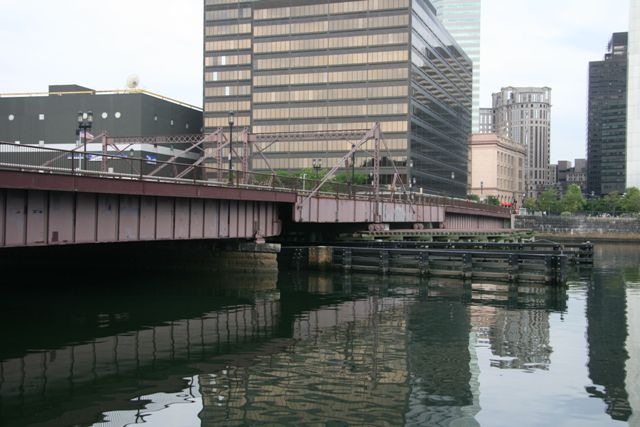
This bridge is one of only a handful of bridges in the country to display the retractile bridge design. In a retractile bridge, the bridge rolls back off of the waterway using a system of tracks and rollers. In the case of Summer Street, the bridge is a paired oblique double-leaf retractile bridge, which means that two sections of the bridge roll back at an angle away from the road and river on the same side of the river. The Summer Street Bridge is the only such example in the country known to survive today. The benefits and ease of constructing other movable bridge types meant that the retractile was never a popular movable bridge type. Although the bridge tender building and much of the machinery that allowed this bridge to operate is removed, this bridge remains today one of the most important movable bridges in the country, as an example of the rarest general movable bridge design (the other general designs being swing, bascule, and vertical lift). The key parts of the retractile design remain in place for historical interpretation, although it appears the overall superstructure which is largely hidden by the original, unaltered outermost set of girders, may be modern and non-historic. However, the tracks and rollers that this bridge would have rolled back on remain unaltered. In addition, the overhead bracing and stabilizing stays, which are called "Samson Posts" also remain.
This bridge is also significant as one of the final examples of the Berlin Iron Bridge Company (made famous by its patented lenticular truss bridges), before the company became a part of the American Bridge Company.
![]()
![]()
![]()
Coordinates (Latitude, Longitude):
Search For Additional Bridge Listings:
Bridgehunter.com: View listed bridges within 0.5 miles (0.8 kilometers) of this bridge.
Bridgehunter.com: View listed bridges within 10 miles (16 kilometers) of this bridge.
Additional Maps:
Google Streetview (If Available)
GeoHack (Additional Links and Coordinates)
Apple Maps (Via DuckDuckGo Search)
Apple Maps (Apple devices only)
Android: Open Location In Your Map or GPS App
Flickr Gallery (Find Nearby Photos)
Wikimedia Commons (Find Nearby Photos)
Directions Via Sygic For Android
Directions Via Sygic For iOS and Android Dolphin Browser
USGS National Map (United States Only)
Historical USGS Topo Maps (United States Only)
Historic Aerials (United States Only)
CalTopo Maps (United States Only)

© Copyright 2003-2025, HistoricBridges.org. All Rights Reserved. Disclaimer: HistoricBridges.org is a volunteer group of private citizens. HistoricBridges.org is NOT a government agency, does not represent or work with any governmental agencies, nor is it in any way associated with any government agency or any non-profit organization. While we strive for accuracy in our factual content, HistoricBridges.org offers no guarantee of accuracy. Information is provided "as is" without warranty of any kind, either expressed or implied. Information could include technical inaccuracies or errors of omission. Opinions and commentary are the opinions of the respective HistoricBridges.org member who made them and do not necessarily represent the views of anyone else, including any outside photographers whose images may appear on the page in which the commentary appears. HistoricBridges.org does not bear any responsibility for any consequences resulting from the use of this or any other HistoricBridges.org information. Owners and users of bridges have the responsibility of correctly following all applicable laws, rules, and regulations, regardless of any HistoricBridges.org information.
![]()