

View Information About HSR Ratings
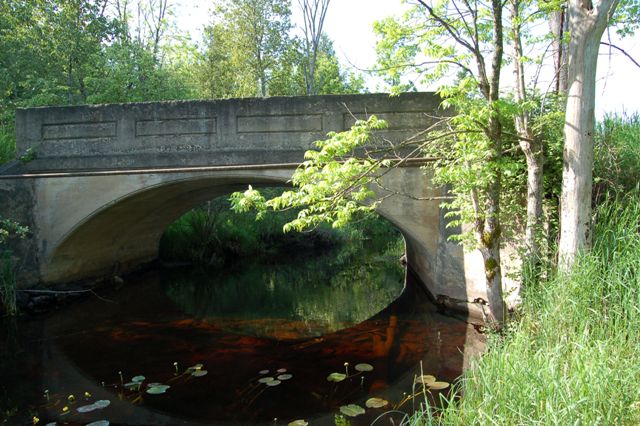
This bridge is an extremely small arch bridge. Despite this, the bridge is still a very beautiful structure. The small size gives the arch different proportions not experienced with larger bridges. Further the excellent historic integrity that includes original railings greatly adds to the aesthetic values of the bridge.
It is unknown who built this bridge. The design and simple aesthetic detailing of the railings is similar to designs used by the Luten Bridge Company and the Illinois Bridge Company. The Illinois Bridge Company was prolific in Michigan, but most examples are in southern Michigan. Illinois Bridge Company and Luten Bridge Company sometimes would both be involved with an arch bridge, with Luten doing the design and Illinois Bridge doing the construction.
The county wants to demolish and replace this bridge with an ugly modern bridge. However, this bridge could instead be rehabilitated, possibly for less or similar cost as replacement, which would also preserve this attractive bridge. The ADT on the road is only 86, which means that the replacement bridge would likely only be a one lane bridge. This means that the existing one-lane bridge is functionally sufficient, and that wide and heavy trucks and such do not need to use the road. As such, the only thing replacement will do is destroy heritage and waste money. Instead, repairs should be made to the existing abutments which have some delamination and scour issues. Based on the decent NBI ratings for the deck and superstructure, only minor repairs would be needed to those areas.

Above: Aerial view of bridge, September 10, 2020. Click for enlargement. Photo Credit: Doug Heim, Angelcopter, LLC

Above: Aerial view of bridge, September 10, 2020. Click for enlargement. Photo Credit: Doug Heim, Angelcopter, LLC

Above: Aerial view of bridge, September 10, 2020. Click for enlargement. Photo Credit: Doug Heim, Angelcopter, LLC
![]()
![]()
![]()

![]()
Coordinates (Latitude, Longitude):
Search For Additional Bridge Listings:
Bridgehunter.com: View listed bridges within 0.5 miles (0.8 kilometers) of this bridge.
Bridgehunter.com: View listed bridges within 10 miles (16 kilometers) of this bridge.
Additional Maps:
Google Streetview (If Available)
GeoHack (Additional Links and Coordinates)
Apple Maps (Via DuckDuckGo Search)
Apple Maps (Apple devices only)
Android: Open Location In Your Map or GPS App
Flickr Gallery (Find Nearby Photos)
Wikimedia Commons (Find Nearby Photos)
Directions Via Sygic For Android
Directions Via Sygic For iOS and Android Dolphin Browser
USGS National Map (United States Only)
Historical USGS Topo Maps (United States Only)
Historic Aerials (United States Only)
CalTopo Maps (United States Only)

© Copyright 2003-2026, HistoricBridges.org. All Rights Reserved. Disclaimer: HistoricBridges.org is a volunteer group of private citizens. HistoricBridges.org is NOT a government agency, does not represent or work with any governmental agencies, nor is it in any way associated with any government agency or any non-profit organization. While we strive for accuracy in our factual content, HistoricBridges.org offers no guarantee of accuracy. Information is provided "as is" without warranty of any kind, either expressed or implied. Information could include technical inaccuracies or errors of omission. Opinions and commentary are the opinions of the respective HistoricBridges.org member who made them and do not necessarily represent the views of anyone else, including any outside photographers whose images may appear on the page in which the commentary appears. HistoricBridges.org does not bear any responsibility for any consequences resulting from the use of this or any other HistoricBridges.org information. Owners and users of bridges have the responsibility of correctly following all applicable laws, rules, and regulations, regardless of any HistoricBridges.org information.
![]()