

View Information About HSR Ratings
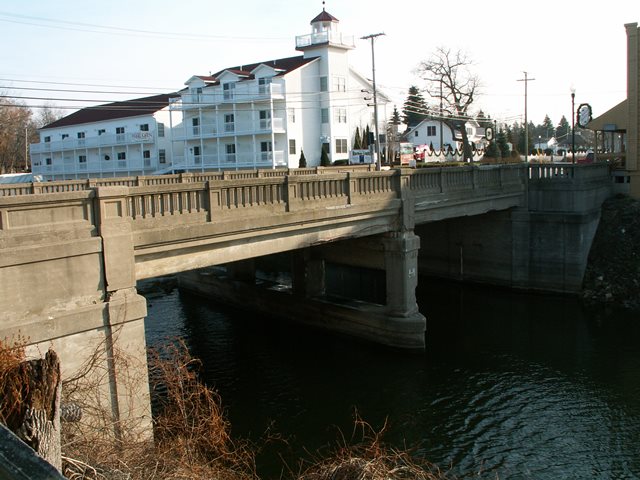
A number of bridges in Michigan similar to this one were built in the late 1920s and early 1930s. In general, those built in the late 1920s included abutment railings that were different from the railings on the bridge, while those built in the early 1930s featured the same railing design along the length. The Caseville Bridge was built in 1929 and does have the different abutment railings. This change in railing design has a positive influence of the bridge, producing an attractive compliment of design.
This bridge is a significant example of this ca. 1930 bridge design, as it retains good historic integrity, with the exception of stolen plaques and what appears to be missing light standards that would have been on the bridge. Among bridges of this style in Michigan, it is a medium-sized structure, composed of two spans. It is fairly wide, with three lanes and a sidewalk on both sides. The southeast end of the bridge has unusual design, where the abutment is extended, and railing system extends with it, apparently to create a safety barrier for the sidewalk between the end of the bridge to the nearby building.
Finally, this bridge is historically significant in regards to its corridor of travel, as it appears to be the oldest remaining bridge on M-25, which is a long trunk line that runs from Port Huron to Bay City along the lakeshore, which for much of its length serves primarily residential and tourism purposes rather than being an efficient truck route.
Very shortly after this bridge was photographed it was demolished and replaced with a mundane structure with no heritage of aesthetic value.
![]()
![]()
![]()
This historic bridge has been demolished. This map is shown for reference purposes only.
Coordinates (Latitude, Longitude):
Search For Additional Bridge Listings:
Bridgehunter.com: View listed bridges within 0.5 miles (0.8 kilometers) of this bridge.
Bridgehunter.com: View listed bridges within 10 miles (16 kilometers) of this bridge.
Additional Maps:
Google Streetview (If Available)
GeoHack (Additional Links and Coordinates)
Apple Maps (Via DuckDuckGo Search)
Apple Maps (Apple devices only)
Android: Open Location In Your Map or GPS App
Flickr Gallery (Find Nearby Photos)
Wikimedia Commons (Find Nearby Photos)
Directions Via Sygic For Android
Directions Via Sygic For iOS and Android Dolphin Browser
USGS National Map (United States Only)
Historical USGS Topo Maps (United States Only)
Historic Aerials (United States Only)
CalTopo Maps (United States Only)

© Copyright 2003-2026, HistoricBridges.org. All Rights Reserved. Disclaimer: HistoricBridges.org is a volunteer group of private citizens. HistoricBridges.org is NOT a government agency, does not represent or work with any governmental agencies, nor is it in any way associated with any government agency or any non-profit organization. While we strive for accuracy in our factual content, HistoricBridges.org offers no guarantee of accuracy. Information is provided "as is" without warranty of any kind, either expressed or implied. Information could include technical inaccuracies or errors of omission. Opinions and commentary are the opinions of the respective HistoricBridges.org member who made them and do not necessarily represent the views of anyone else, including any outside photographers whose images may appear on the page in which the commentary appears. HistoricBridges.org does not bear any responsibility for any consequences resulting from the use of this or any other HistoricBridges.org information. Owners and users of bridges have the responsibility of correctly following all applicable laws, rules, and regulations, regardless of any HistoricBridges.org information.
![]()