

View Information About HSR Ratings
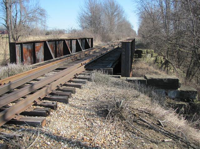
This bridge carries the Coopersville and Marne Railway, east of the tour train portion. The line dates back to 1858, before the railroad grade this bridge crosses was
built.
The railroad line this bridge crosses is today abandoned and even filled in under this bridge. It was originally built in 1886 as the Muskegon, Grand Rapids and Indiana Railroad. The bridge's stone abutments have a carving in the
top of the northwest abutment which seems to include the date "1888". This suggests that the stone abutments could well be original, although the plate girder span itself wouldn't necessarily be. However, it is possible that the plate
girder is original, and if so it would be one of the oldest plate girder bridges known in Michigan. The plate girder has some unusual details that suggest it might be an 1888 plate girder. One example is that there is a latticed beam found
under the deck, something not normally found on a plate girder.
At the time of documentation, clearing had taken place along the north side of the rail line here as part of the Musketawa Connector trail, which was later paved along this stretch that summer. It is unclear how much of the barrier berm found under the bridge today is due to this, but some of it is certainly older. The section of line under the bridge was abandoned in 1960, and I-96 was built over it just to the south. By then a connection had been made between the 2 lines just west of here, perhaps in 1946 when Grand Trunk, which then owned the Coopersville/Grand Haven line, began using the other for access to Muskegon. The rest of the rails on the Muskegon line were taken up in 1990, and most of it became the Musketawa Trail.
![]()
![]()
![]()
Coordinates (Latitude, Longitude):
Search For Additional Bridge Listings:
Bridgehunter.com: View listed bridges within 0.5 miles (0.8 kilometers) of this bridge.
Bridgehunter.com: View listed bridges within 10 miles (16 kilometers) of this bridge.
Additional Maps:
Google Streetview (If Available)
GeoHack (Additional Links and Coordinates)
Apple Maps (Via DuckDuckGo Search)
Apple Maps (Apple devices only)
Android: Open Location In Your Map or GPS App
Flickr Gallery (Find Nearby Photos)
Wikimedia Commons (Find Nearby Photos)
Directions Via Sygic For Android
Directions Via Sygic For iOS and Android Dolphin Browser
USGS National Map (United States Only)
Historical USGS Topo Maps (United States Only)
Historic Aerials (United States Only)
CalTopo Maps (United States Only)

© Copyright 2003-2026, HistoricBridges.org. All Rights Reserved. Disclaimer: HistoricBridges.org is a volunteer group of private citizens. HistoricBridges.org is NOT a government agency, does not represent or work with any governmental agencies, nor is it in any way associated with any government agency or any non-profit organization. While we strive for accuracy in our factual content, HistoricBridges.org offers no guarantee of accuracy. Information is provided "as is" without warranty of any kind, either expressed or implied. Information could include technical inaccuracies or errors of omission. Opinions and commentary are the opinions of the respective HistoricBridges.org member who made them and do not necessarily represent the views of anyone else, including any outside photographers whose images may appear on the page in which the commentary appears. HistoricBridges.org does not bear any responsibility for any consequences resulting from the use of this or any other HistoricBridges.org information. Owners and users of bridges have the responsibility of correctly following all applicable laws, rules, and regulations, regardless of any HistoricBridges.org information.
![]()