We Recommend:
Bach Steel - Experts at historic truss bridge restoration.
BridgeHunter.com Phase 1 is released to the public! - Visit Now
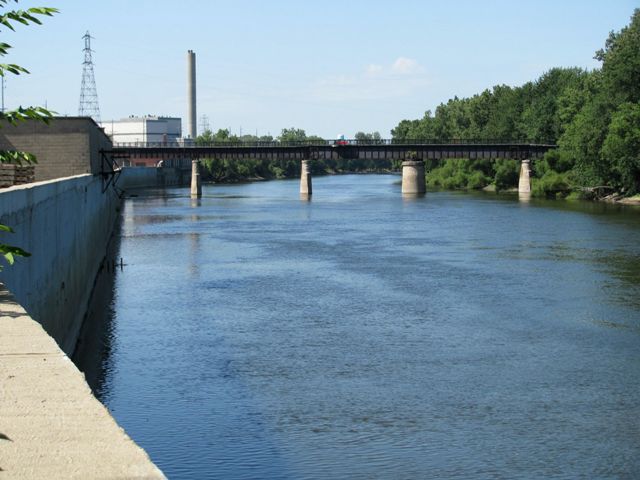
Michigan Railway Grand River Bridge

Primary Photographer(s): Randy Mulder
Bridge Documented: July 20, 2010
Grand Rapids: Kent County, Michigan: United States
Metal Deck Girder, Movable: Swing (Center Pier) and Approach Spans: Metal Deck Girder, Fixed
1914 By Builder/Contractor: Toledo Bridge and Crane Company of Toledo, Ohio
Not Available or Not Applicable
200.0 Feet (61 Meters)
680.0 Feet (207.3 Meters)
12 Feet (3.66 Meters)
1 Main Span(s) and 3 Approach Span(s)
Not Applicable

View Information About HSR Ratings
Bridge Documentation
View a 1915 Article About the Michigan Railway
This bridge is a deck plate girder swing bridge, although for the majority of its history the bridge has functioned as a fixed bridge, since the need for movable bridges on the Grand River ended shortly after it was built. All the machinery of the swing has been removed, with only the main gear, rollers, and circular pier identifying one of the spans as a swing span. The bridge originally served the Michigan Railway, which was an electric interurban facility that also included the Gillette Bridge. The metal structures seen on the sides of the bridge are what is left of the towers that held the overhead electric lines to power the trains. The system was built to such high standards that this bridge was used by conventional trains for decades after the interurban went out of business. The bridge later stood abandoned for many years, but was converted into a rail-trail facility in 2010.
Information and Findings From Historic American Engineering Record SurveyDiscussion of Bridge This swing bridge was erected to carry the Michigan Central Railroad over Market Street and the Grand River. The builder was the Toledo Bridge and Crane Company of Toledo, Ohio. It is a simple steel girder bridge, 12 feet wide and approximately 680 feet long. it consists of two parallel steel girders, eight feet high, with six inch steel I'beams as crossmembers supporting the roadbed. There are four spans resting on concrete piers and abutments. Proceeding from east to west, the first span (crossing Market Street and extending over the Grand River) is 200 feet long, the next span is 100 feet long, the swing span in 200 feet long, and finally, the westernmost span is l80 feet in length. The swing span is no longer moveable and the line itself has been abandoned for at least a decade. |
![]()
Photo Galleries and Videos: Michigan Railway Grand River Bridge
Bridge Photo-Documentation
Original / Full Size PhotosA collection of overview and detail photos. This gallery offers photos in the highest available resolution and file size in a touch-friendly popup viewer.
Alternatively, Browse Without Using Viewer
![]()
Bridge Photo-Documentation
Mobile Optimized PhotosA collection of overview and detail photos. This gallery features data-friendly, fast-loading photos in a touch-friendly popup viewer.
Alternatively, Browse Without Using Viewer
![]()
Maps and Links: Michigan Railway Grand River Bridge
Coordinates (Latitude, Longitude):
Search For Additional Bridge Listings:
Bridgehunter.com: View listed bridges within 0.5 miles (0.8 kilometers) of this bridge.
Bridgehunter.com: View listed bridges within 10 miles (16 kilometers) of this bridge.
Additional Maps:
Google Streetview (If Available)
GeoHack (Additional Links and Coordinates)
Apple Maps (Via DuckDuckGo Search)
Apple Maps (Apple devices only)
Android: Open Location In Your Map or GPS App
Flickr Gallery (Find Nearby Photos)
Wikimedia Commons (Find Nearby Photos)
Directions Via Sygic For Android
Directions Via Sygic For iOS and Android Dolphin Browser
USGS National Map (United States Only)
Historical USGS Topo Maps (United States Only)
Historic Aerials (United States Only)
CalTopo Maps (United States Only)

