


View Information About HSR Ratings

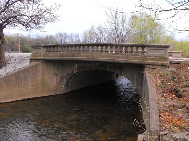
The Kearsley Park Boulevard Bridge is the smallest of Flint's once impressive collection of arch bridges. However it is today noteworthy because it retains original railings and has not been demolished. The bridge's original balustrade railings are similar to most of the other arch bridges documented in Flint. The bridge appears to be unaltered from its original construction.
Kearsley Park was created in 1917, and today there are several structures remaining in the park that appear to date to the period and remain in unaltered condition. The Kearsley Park Boulevard Bridge is one of these structures. The other is an tiny and unusual concrete tunnel-like overpass on Kearsley Park Boulevard located a tiny distance west of the bridge. This overpass allows a trail to pass under the bridge. The overpass is somewhat interesting, with gracefully curved abutments giving the structure an attractive appearance to those walking through it. The structure is not discernable from on the road. Finally, the Donnelly Pavilion located in the park was built in 1925. All three of these structures contribute beauty and history to Kearsley Park and the preservation of all three of these structures should be considered.

This bridge is tagged with the following special condition(s): Unorganized Photos
![]()
![]()
![]()
![]()
![]()
Coordinates (Latitude, Longitude):
Search For Additional Bridge Listings:
Bridgehunter.com: View listed bridges within 0.5 miles (0.8 kilometers) of this bridge.
Bridgehunter.com: View listed bridges within 10 miles (16 kilometers) of this bridge.
Additional Maps:
Google Streetview (If Available)
GeoHack (Additional Links and Coordinates)
Apple Maps (Via DuckDuckGo Search)
Apple Maps (Apple devices only)
Android: Open Location In Your Map or GPS App
Flickr Gallery (Find Nearby Photos)
Wikimedia Commons (Find Nearby Photos)
Directions Via Sygic For Android
Directions Via Sygic For iOS and Android Dolphin Browser
USGS National Map (United States Only)
Historical USGS Topo Maps (United States Only)
Historic Aerials (United States Only)
CalTopo Maps (United States Only)

© Copyright 2003-2026, HistoricBridges.org. All Rights Reserved. Disclaimer: HistoricBridges.org is a volunteer group of private citizens. HistoricBridges.org is NOT a government agency, does not represent or work with any governmental agencies, nor is it in any way associated with any government agency or any non-profit organization. While we strive for accuracy in our factual content, HistoricBridges.org offers no guarantee of accuracy. Information is provided "as is" without warranty of any kind, either expressed or implied. Information could include technical inaccuracies or errors of omission. Opinions and commentary are the opinions of the respective HistoricBridges.org member who made them and do not necessarily represent the views of anyone else, including any outside photographers whose images may appear on the page in which the commentary appears. HistoricBridges.org does not bear any responsibility for any consequences resulting from the use of this or any other HistoricBridges.org information. Owners and users of bridges have the responsibility of correctly following all applicable laws, rules, and regulations, regardless of any HistoricBridges.org information.
![]()