

View Information About HSR Ratings
Note: Lengths given are estimates.
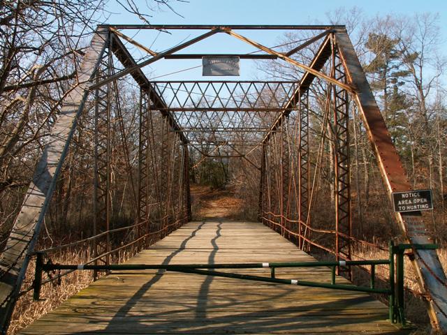
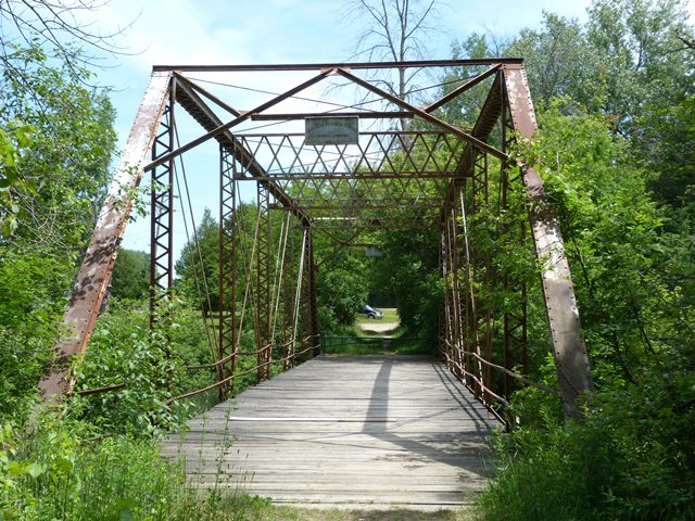
Port Crescent is a long-lost ghost town of which very little remains. Indeed, where a town once stood is now a state park that is open to hunting and offers some hiking trails. This bridge, which leads nowhere but to some of those hiking trails, most like was once a way to enter the town of Port Crescent. Today the structure, which seems like it leads nowhere, is a last remnant of this community. Even more unusual, the bridge appears at first to cross nothing more than a swamp. It actually crosses the Old Pinnebog River. Some time ago, mother nature filled in the Pinnebog River before it reaches the bridge and caused the river to divert to a nearby Lake Huron inlet to the west of the bridge, rather than winding along the shore a bit, under the bridge and then out to the lake east of the bridge. As a result, today the Old Pinnebog River is really just a swampy low-land.
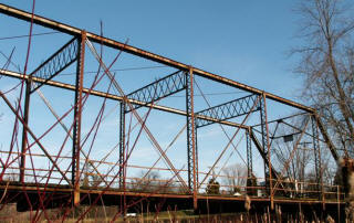
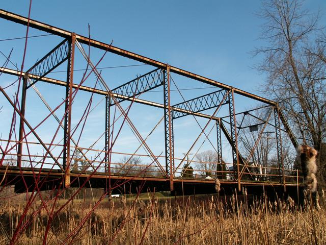
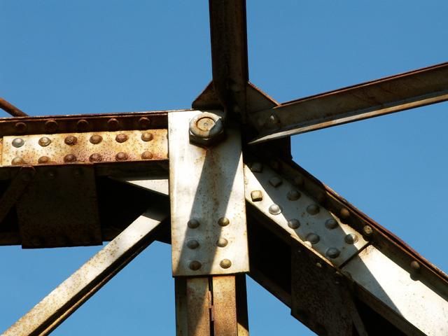
By 2006, with all hope of the Frith Road Bridge staying in St. Clair County gone, this bridge became the last remaining highway through truss known in the thumb area, except for the Blue Water Bridge. The bridge is a rare example of work done by the Michigan Bridge and Pipe Company of Lansing Michigan. The 133rd Avenue Bridge was listed as having been built by a Michigan Bridge Company. This may actually be the same company. The Port Crescent Road Bridge is a rare Michigan truss bridge, with some unusual design characteristics, that retains a builder plaque. Unfortunately, no date is shown on the relatively simple plaque, which is mounted unusually below the a-frame portal bracing. The structure is a six panel pin-connected Pratt through truss. It retains a wooden deck. The bridge retails original metal railings. The vertical members are a lightweight built-up design usually only seen on pony truss bridges. The sway bracing is also quite unusual and larger in size than on the average pin-connected truss bridge of this size. V-lacing is present on the verticals and under the top chord and end post. Lattice is present on the sway bracing, and as mentioned, the portal bracing is an a-frame design. Remnants of silver paint still remain on the bridge, and rust damage is minimal. The structure is gated off, suggesting that park service vehicles may still use the structure. Located in a state park that has walking trails that can be accessed using this bridge, the structure is an ideal candidate for restoration in its current location for light vehicular/pedestrian use. The structure is regionally significant as the last remaining pin-connected through highway truss in the thumb area. It has statewide significance as a rare example of a bridge built by the Michigan Bridge and Pipe Company. It is also significant for its unusual vertical members and sway bracing, and for retaining excellent historic integrity. Finally, the bridge is significant as a remnant of the long-lost town of Port Crescent, the last remaining obvious hint that a community was once present near the mouth of the Pinnebog River.
Little is known about the Michigan Bridge and Pipe Company. It was listed in a 1908 Lansing directory. William R. Yuill was president of the company. H. S. Putney was vice president. William A. Yuill was secretary and manager. Charles G. Putney was treasurer. The address was 626 South Hosmer Street. The 33rd Annual Report by Michigan Department of Labor dated 1916 included a listing of companies including the Michigan Bridge and Pipe Company. It states that twelve males and one female were employed by the company, for a total of thirteen. It states that the business was established in 1908. If this is true, this would suggest that the bridge dates to 1908 or later, which would make it a late example of a pin-connected truss bridge. Furthermore, it would suggest that this bridge is not a remnant of the Ghost Town of Port Crescent, which died out after the fire of 1881.
This bridge is tagged with the following special condition(s): Unorganized Photos
![]()
![]()
![]()
![]()
![]()
![]()
Coordinates (Latitude, Longitude):
Search For Additional Bridge Listings:
Bridgehunter.com: View listed bridges within 0.5 miles (0.8 kilometers) of this bridge.
Bridgehunter.com: View listed bridges within 10 miles (16 kilometers) of this bridge.
Additional Maps:
Google Streetview (If Available)
GeoHack (Additional Links and Coordinates)
Apple Maps (Via DuckDuckGo Search)
Apple Maps (Apple devices only)
Android: Open Location In Your Map or GPS App
Flickr Gallery (Find Nearby Photos)
Wikimedia Commons (Find Nearby Photos)
Directions Via Sygic For Android
Directions Via Sygic For iOS and Android Dolphin Browser
USGS National Map (United States Only)
Historical USGS Topo Maps (United States Only)
Historic Aerials (United States Only)
CalTopo Maps (United States Only)

© Copyright 2003-2026, HistoricBridges.org. All Rights Reserved. Disclaimer: HistoricBridges.org is a volunteer group of private citizens. HistoricBridges.org is NOT a government agency, does not represent or work with any governmental agencies, nor is it in any way associated with any government agency or any non-profit organization. While we strive for accuracy in our factual content, HistoricBridges.org offers no guarantee of accuracy. Information is provided "as is" without warranty of any kind, either expressed or implied. Information could include technical inaccuracies or errors of omission. Opinions and commentary are the opinions of the respective HistoricBridges.org member who made them and do not necessarily represent the views of anyone else, including any outside photographers whose images may appear on the page in which the commentary appears. HistoricBridges.org does not bear any responsibility for any consequences resulting from the use of this or any other HistoricBridges.org information. Owners and users of bridges have the responsibility of correctly following all applicable laws, rules, and regulations, regardless of any HistoricBridges.org information.
![]()