HistoricBridges.org Menu: HistoricBridges.org Menu:


We Recommend:
Bach Steel - Experts at historic truss bridge restoration.

HistoricBridges.org: Bridge Browser

Rodesiler Highway Bridge

Rodesiler Highway Bridge

Primary Photographer(s): Nathan Holth

Bridge Documented: May 13, 2011

View Photos
and Videos
View Maps
and Links

Facility Carried / Feature Intersected
Rodesiler Highway Over Draper Drain
Location
Rural: Lenawee County, Michigan: United States
Structure Type
Concrete Through Girder, Fixed
Construction Date and Builder / Engineer
1924 By Builder/Contractor: Unknown and Engineer/Design: Michigan State Highway Department
Rehabilitation Date
Not Available or Not Applicable
Main Span Length
30.0 Feet (9.1 Meters)
Structure Length
30.0 Feet (9.1 Meters)
Roadway Width
20 Feet (6.1 Meters)
Spans
1 Main Span(s)
Inventory Number
46200089000B010

Historic Significance Rating (HSR)
View Information About HSR Ratings

Bridge Documentation

This bridge no longer exists!

Bridge Status: Demolished and replaced.

View Archived National Bridge Inventory Report - Has Additional Details and Evaluation

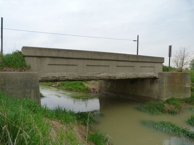
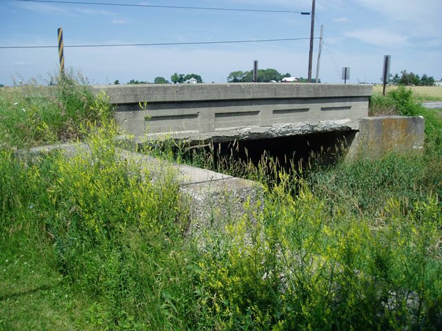
This bridge is a short concrete through girder in Michigan. It retains good historic integrity. Unfortunately this bridge has become an example of the cost of deferred maintenance and repair in terms of both heritage and taxpayer dollars, since the bridge is today in poor condition. Now, the county road commission has applied for funding to demolish and replace this bridge with a mundane modern slab of concrete. This is unfortunate, since this is the only known example of a concrete girder bridge in the county, and it makes a nice comparison to a few concrete girders located in Lucas County, Ohio to the south.

Divider

Photo Galleries and Videos: Rodesiler Highway Bridge


View Photo Gallery

Bridge Photo-Documentation

Original / Full Size Photos
A collection of overview and detail photos. This gallery offers photos in the highest available resolution and file size in a touch-friendly popup viewer.
Alternatively, Browse Without Using Viewer

Divider

View Photo Gallery

Bridge Photo-Documentation

Mobile Optimized Photos
A collection of overview and detail photos This gallery features data-friendly, fast-loading photos in a touch-friendly popup viewer.
Alternatively, Browse Without Using Viewer

Divider

View Photo Gallery

MDOT Bridge Photo-Documentation

Original / Full Size Photos
A collection of overview and detail photos. taken by MDOT This gallery offers photos in the highest available resolution and file size in a touch-friendly popup viewer.
Alternatively, Browse Without Using Viewer

Divider

View Photo Gallery

MDOT Bridge Photo-Documentation

Mobile Optimized Photos
A collection of overview and detail photos taken by MDOT. This gallery features data-friendly, fast-loading photos in a touch-friendly popup viewer.
Alternatively, Browse Without Using Viewer

Divider

Maps and Links: Rodesiler Highway Bridge

This historic bridge has been demolished. This map is shown for reference purposes only.

Coordinates (Latitude, Longitude):

Search For Additional Bridge Listings:

Bridgehunter.com: View listed bridges within 0.5 miles (0.8 kilometers) of this bridge.

Bridgehunter.com: View listed bridges within 10 miles (16 kilometers) of this bridge.

HistoricBridges.org Bridge Browser: View listed bridges within 0.5 miles (0.8 kilometers) of this bridge.

HistoricBridges.org Bridge Browser: View listed bridges within 10 miles (16 kilometers) of this bridge.

2021 National Bridge Inventory: View listed bridges within 0.5 miles (0.8 kilometers) of this bridge.

Additional Maps:

Google Maps

Google Streetview (If Available)

Bing Maps

OpenStreetMap

GeoHack (Additional Links and Coordinates)

Apple Maps (Via DuckDuckGo Search)

Apple Maps (Apple devices only)

MapQuest

HERE We Go Maps

ACME Mapper

Waze Map

Android: Open Location In Your Map or GPS App

Flickr Gallery (Find Nearby Photos)

Wikimedia Commons (Find Nearby Photos)

Directions Via Sygic For Android

Directions Via Sygic For iOS and Android Dolphin Browser

USGS National Map (United States Only)

Historical USGS Topo Maps (United States Only)

Historic Aerials (United States Only)

CalTopo Maps (United States Only)


Divider
 
Home Top

Divider

About - Contact

© Copyright 2003-2024, HistoricBridges.org. All Rights Reserved. Disclaimer: HistoricBridges.org is a volunteer group of private citizens. HistoricBridges.org is NOT a government agency, does not represent or work with any governmental agencies, nor is it in any way associated with any government agency or any non-profit organization. While we strive for accuracy in our factual content, HistoricBridges.org offers no guarantee of accuracy. Information is provided "as is" without warranty of any kind, either expressed or implied. Information could include technical inaccuracies or errors of omission. Opinions and commentary are the opinions of the respective HistoricBridges.org member who made them and do not necessarily represent the views of anyone else, including any outside photographers whose images may appear on the page in which the commentary appears. HistoricBridges.org does not bear any responsibility for any consequences resulting from the use of this or any other HistoricBridges.org information. Owners and users of bridges have the responsibility of correctly following all applicable laws, rules, and regulations, regardless of any HistoricBridges.org information.

Admin Login

Divider