

View Information About HSR Ratings
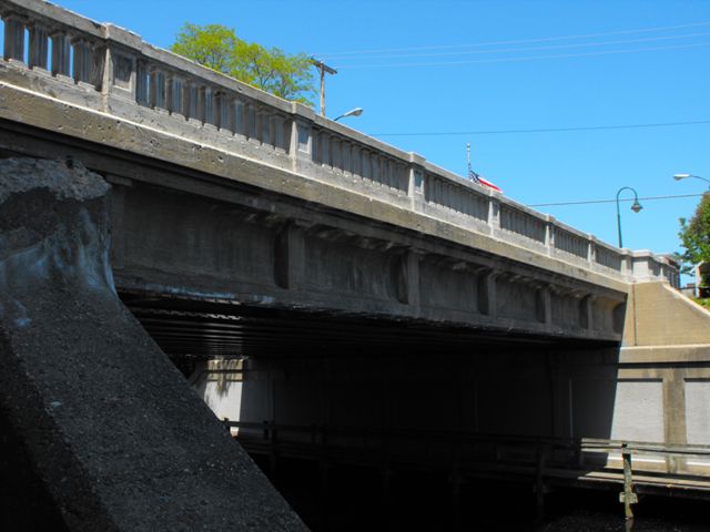
This bridge is one of the most noteworthy and important of Traverse City's collection of old bridges scattered throughout downtown. It is a historically intact, and wide, example of a stringer bridge built to a design that was used in the late 1920s and early 1930s in Michigan. The design features included concrete facade over the outside of the steel stringers at the sides of the bridge, and a unique concrete balustrade railing. This particular example also includes built-up beams which is not present on all examples of this standard plan bridge form. The built-up beams on this bridge may be due to the fact that this bridge is a fairly long single-span stringer structure, which required very deep stringers. Unique features on this bridge include additional architectural treatment to the large concrete abutments. The Historic Bridge Inventory comments that this was done because it was realized that Traverse City was an important tourist destination and they wanted the bridge to look nice.
Information and Findings From Michigan Historic Sites OnlineNarrative Description South Union Street, originally US-31, crosses the Boardman River just south of downtown Traverse City. The city's main post office is northwest of the bridge. To the south is a well-preserved turn-of-the-century residential neighborhood. The main public library is west of the bridge on the river's south bank. The river is edged by an attractive park, which includes a walkway that passes beneath the bridge. Stairs lead down to the park near both sides of the bridge's south end. A low dam is slightly upstream to the east. Further to the east is the next river crossing, the handsome concrete-arch Cass Street Bridge. The South Union Street Bridge is skewed. The span's twelve I-beam girders are built up from plates and angles riveted together. The outer girders are faced with concrete with recessed panels, which curve out at the top to meet the slightly projecting bridge deck. The concrete balustrade railing has square-section spindles ornamented with two incised vertical lines. At each end are solid concrete parapets. The bridge maintains excellent integrity. Statement of Significance In 1929, the city began planning to replace dangerous bridges over the Boardman River at Cass and South Union Streets. When the city learned that the state might take responsibility for the Union Street crossing, it turned its attention to the Cass Street project, while pressuring the state to build the South Union Street Bridge. State bridge engineer Charles Melick visited Traverse City in October 1929, and concurred that a new bridge was urgently needed. The department completed a survey of the site by December, and sent preliminary plans for review by the city board in the following July. Bids for erecting the structure were due 31 December 1930, and the department opened the bids a week later. L. W. Lamb, a contractor from Jackson, won the contract for $66, 482. There were additional expenditures for structural steel ($4,959), aggregates ($3, 593) field pint ($253), and other items, bringing the project cost to nearly $78,000. An article in a December 1931 issue of Michigan Roads and Airports reported on the importance of the appearance of the bridge, which was located in a park and served as a major gateway for tourists arriving in the city: "Careful attention was given to the dressing up and sodding of the banks and the face of the reinforced concrete abutments have been paneled and the brush hammered as a further aesthetic treatment." Although it is no longer designated as a federal or state route, the South Union Street Bridge is an attractive, well-preserved reminder of the influence of the tourism industry on bridge aesthetics, and of the increasing importance of tourism in this area during the first decades of the twentieth century. As a result, it is eligible for the National Register under Criterion A. |
![]()
![]()
![]()
Coordinates (Latitude, Longitude):
Search For Additional Bridge Listings:
Bridgehunter.com: View listed bridges within 0.5 miles (0.8 kilometers) of this bridge.
Bridgehunter.com: View listed bridges within 10 miles (16 kilometers) of this bridge.
Additional Maps:
Google Streetview (If Available)
GeoHack (Additional Links and Coordinates)
Apple Maps (Via DuckDuckGo Search)
Apple Maps (Apple devices only)
Android: Open Location In Your Map or GPS App
Flickr Gallery (Find Nearby Photos)
Wikimedia Commons (Find Nearby Photos)
Directions Via Sygic For Android
Directions Via Sygic For iOS and Android Dolphin Browser
USGS National Map (United States Only)
Historical USGS Topo Maps (United States Only)
Historic Aerials (United States Only)
CalTopo Maps (United States Only)

© Copyright 2003-2026, HistoricBridges.org. All Rights Reserved. Disclaimer: HistoricBridges.org is a volunteer group of private citizens. HistoricBridges.org is NOT a government agency, does not represent or work with any governmental agencies, nor is it in any way associated with any government agency or any non-profit organization. While we strive for accuracy in our factual content, HistoricBridges.org offers no guarantee of accuracy. Information is provided "as is" without warranty of any kind, either expressed or implied. Information could include technical inaccuracies or errors of omission. Opinions and commentary are the opinions of the respective HistoricBridges.org member who made them and do not necessarily represent the views of anyone else, including any outside photographers whose images may appear on the page in which the commentary appears. HistoricBridges.org does not bear any responsibility for any consequences resulting from the use of this or any other HistoricBridges.org information. Owners and users of bridges have the responsibility of correctly following all applicable laws, rules, and regulations, regardless of any HistoricBridges.org information.
![]()