We Recommend:
Bach Steel - Experts at historic truss bridge restoration.
Concord Railroad Bridge

Primary Photographer(s): Nathan Holth
Bridge Documented: November 1, 2010
Railroad (Falling Waters Rail-Trail) Over Mill Pond (North Branch Kalamazoo River)
Concord: Jackson County, Michigan: United States
Not Available or Not Applicable
Not Available
Not Available
Not Available
3 Main Span(s)
Not Applicable

View Information About HSR Ratings
Bridge Documentation
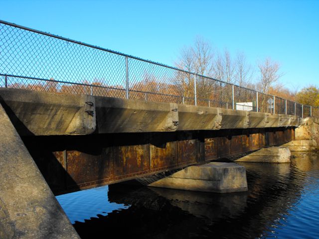
This bridge is on an abandoned railroad line that has been converted into a rail-trail with a small park also planned for next to the bridge.
This small three span deck plate girder is an example of what is perhaps one of the most common type of railroad bridges in Michigan and indeed the United States, but it might have some local significance. Often historic bridges are not fully evaluated for historic significance at the local level. This is because those involved with historic bridges, whether a hired consultant for a government agency or an international historic bridge documentation and advocacy website like HistoricBridges.org, those involved with such entities do not have the time to do the extensive research of digging through archives, doing face-to-face interviews of locals, etc, that is often needed to establish local significance. It is often up to local communities to advocate for local significance. Even if this small deck plate girder might not have local significance enough for listing in the National Register of Historic Places, it might be worth the community posting some information about the bridge on some interpretive signage in the planned park. Such interpretive signage could also discuss the history of the railroad line as a whole as well. Even if bridge and rail line are not National Register eligible, they still might tell a story about the development of Concord. Often the history and heritage of abandoned railroad lines are ignored by those who develop rails to trails, which is most unfortunate. More often then not, the bridges are covered up by ugly railings and no interpretation of the railroad line and any bridges on it is provided to the public. HistoricBridges.org encourages rails to trails organizations to embrace the heritage of the corridors they occupy and not ignore and cover up this history.
![]()
Photo Galleries and Videos: Concord Railroad Bridge
Bridge Photo-Documentation
Original / Full Size PhotosA collection of overview and detail photos. This gallery offers photos in the highest available resolution and file size in a touch-friendly popup viewer.
Alternatively, Browse Without Using Viewer
![]()
Bridge Photo-Documentation
Mobile Optimized PhotosA collection of overview and detail photos. This gallery features data-friendly, fast-loading photos in a touch-friendly popup viewer.
Alternatively, Browse Without Using Viewer
![]()
Maps and Links: Concord Railroad Bridge
Coordinates (Latitude, Longitude):
Search For Additional Bridge Listings:
Bridgehunter.com: View listed bridges within 0.5 miles (0.8 kilometers) of this bridge.
Bridgehunter.com: View listed bridges within 10 miles (16 kilometers) of this bridge.
Additional Maps:
Google Streetview (If Available)
GeoHack (Additional Links and Coordinates)
Apple Maps (Via DuckDuckGo Search)
Apple Maps (Apple devices only)
Android: Open Location In Your Map or GPS App
Flickr Gallery (Find Nearby Photos)
Wikimedia Commons (Find Nearby Photos)
Directions Via Sygic For Android
Directions Via Sygic For iOS and Android Dolphin Browser
USGS National Map (United States Only)
Historical USGS Topo Maps (United States Only)
Historic Aerials (United States Only)
CalTopo Maps (United States Only)

