

View Information About HSR Ratings

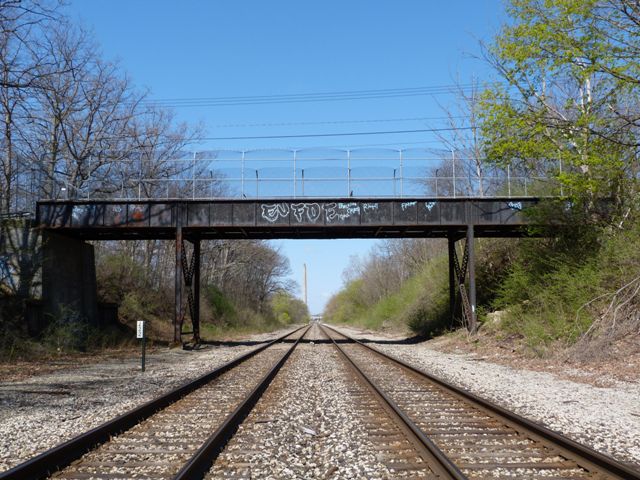
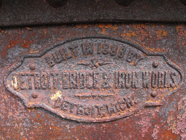
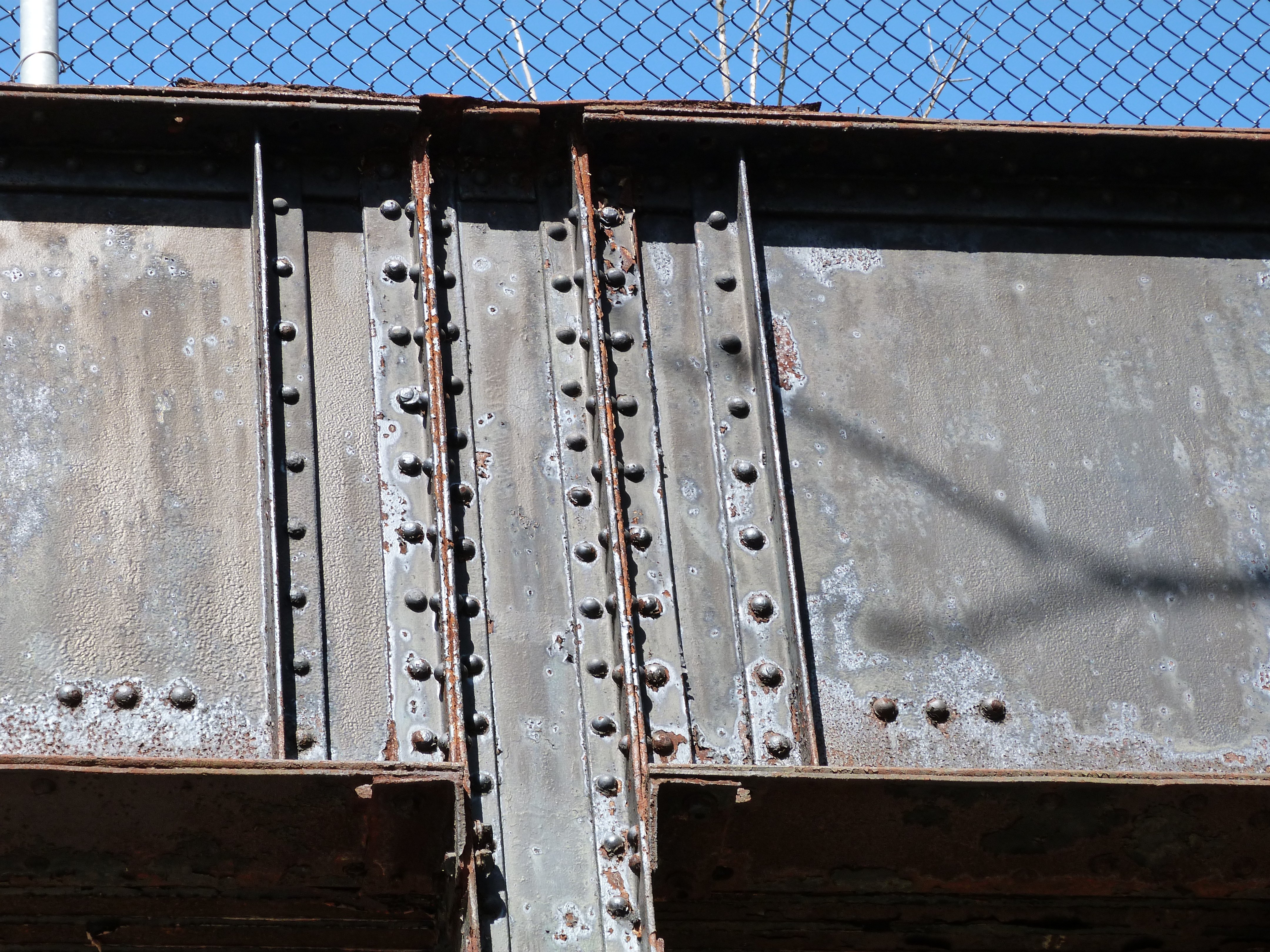
This bridge is a three span continuous through plate girder supported by metal bents and concrete abutments. The plate girder has a plaque on it listing an 1886 construction date. This makes the plate girder an extremely old example of its kind. It is the oldest known confirmed date for a highway plate girder in Michigan. It likely is older than most if not all of Michigan's railroad plate girders as well. Outside of Michigan, this bridge would still hold its own as an extremely early surviving plate girder, even in states with higher populations of plate girder bridges. As such, while this bridge is an example of a simple and unadorned structure type, the bridge is given a high level of historic significance by HistoricBridges.org because it is an extremely early example that represents the earlier development of a structure type that would become an extremely common bridge type. Unfortunately, the bridge appears to have been skipped by the Historic Bridge Inventory because the bridge apparently was already closed and de-listed from the national bridge inventory when the inventory was done, so its significance has not been formally evaluated and recognized.
The bridge also comes with a bit of a mystery. While the plate girder has an 1886 plaque on it, the abutments the abutments are concrete and have a 1919 date marker in them. Further, the steel bent for the bridge has a faint Carnegie USA brand on it. The font and the "USA" on the name are typical of 20th century Carnegie steel, not iron or steel made in 1886. Solving this mystery requires learning the history of the adjacent Potter Park. Tucked away in a brochure about the Potter Park and Zoo is the following paragraph:
The 85 acres of land donated in 1915 and 1917 by James W. and Sarah Potter, to be used as a public park, continue to serve our community today. Mr. and Mrs. Potter placed several contingencies upon city forefathers prior to the 1917 deed being transferred to the city. The most enduring being the construction of the Dakin Street Bridge. J.W. and Sarah Potter joined a nationwide trend to conserve parklands for future generations.
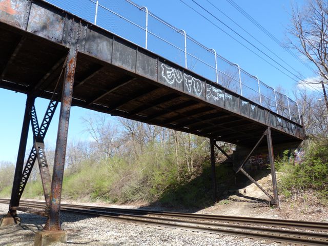
This paragraph appears to indicate that the grade separation here at Dakin Street was built in 1919 as the abutments state and the 20th Century Carnegie brand implies. This would also mean that the 1886 girders are girders that were salvaged and reused from some other bridge that was being replaced. This also helps explain why the bridge is configured as a continuous girder. Simple span girders were far more common in 1886. However, by 1919, engineers were building continuous spans more frequently, and it appears that when the girders were reused here they were converted to function as continuous spans. Another oddity is that although the much shorter end spans have girders that are the same depth as the longer center spans. Shorter spans do not need girders that are as deep as those for longer spans. It may be that when the girders were salvaged, one long girder span was cut in half to form two shorter girder spans. In this sense, the end spans may be "overbuilt" for their function compared to the center span.
This bridge once provided a vehicular and pedestrian connection to Potter Park to areas north of the park by carrying Dakin Street over the CN railroad mainline which also carries the Amtrak Bluewater line. It has for many years now been closed to vehicular traffic. The bridge suffers from severe deterioration and today the sidewalk is closed and the vehicular deck now serves pedestrians only. A followup visit in November 2012 found the gates locked. It is not known if the bridge is now permanently closed, or if the bridge was just not unlocked that day. The deck is the primary area of deterioration. Consisting of a concrete filled metal grate deck, this deck type over time tends to literally bulge up as it deteriorates and today their is a large bulge in the deck and some holes are also visible on the deck.
This bridge is tagged with the following special condition(s): Unorganized Photos
![]()
![]()
![]()
![]()
![]()
![]()
![]()
This historic bridge has been demolished. This map is shown for reference purposes only.
Coordinates (Latitude, Longitude):
Search For Additional Bridge Listings:
Bridgehunter.com: View listed bridges within 0.5 miles (0.8 kilometers) of this bridge.
Bridgehunter.com: View listed bridges within 10 miles (16 kilometers) of this bridge.
Additional Maps:
Google Streetview (If Available)
GeoHack (Additional Links and Coordinates)
Apple Maps (Via DuckDuckGo Search)
Apple Maps (Apple devices only)
Android: Open Location In Your Map or GPS App
Flickr Gallery (Find Nearby Photos)
Wikimedia Commons (Find Nearby Photos)
Directions Via Sygic For Android
Directions Via Sygic For iOS and Android Dolphin Browser
USGS National Map (United States Only)
Historical USGS Topo Maps (United States Only)
Historic Aerials (United States Only)
CalTopo Maps (United States Only)

© Copyright 2003-2024, HistoricBridges.org. All Rights Reserved. Disclaimer: HistoricBridges.org is a volunteer group of private citizens. HistoricBridges.org is NOT a government agency, does not represent or work with any governmental agencies, nor is it in any way associated with any government agency or any non-profit organization. While we strive for accuracy in our factual content, HistoricBridges.org offers no guarantee of accuracy. Information is provided "as is" without warranty of any kind, either expressed or implied. Information could include technical inaccuracies or errors of omission. Opinions and commentary are the opinions of the respective HistoricBridges.org member who made them and do not necessarily represent the views of anyone else, including any outside photographers whose images may appear on the page in which the commentary appears. HistoricBridges.org does not bear any responsibility for any consequences resulting from the use of this or any other HistoricBridges.org information. Owners and users of bridges have the responsibility of correctly following all applicable laws, rules, and regulations, regardless of any HistoricBridges.org information.
![]()