We Recommend:
Bach Steel - Experts at historic truss bridge restoration.
Duffield Road Bridge

Primary Photographer(s): Nathan Holth and Rick McOmber
Bridge Documented: October 9, 2009
Rural: Genesee County, Michigan: United States
1924 By Builder/Contractor: Paul Weinlander of Saline, Michigan and Engineer/Design: Michigan State Highway Department
Not Available or Not Applicable
41.0 Feet (12.5 Meters)
45.0 Feet (13.7 Meters)
23 Feet (7.01 Meters)
1 Main Span(s)
Not Applicable

View Information About HSR Ratings
Bridge Documentation
This bridge no longer exists!
This bridge was demolished and replaced!
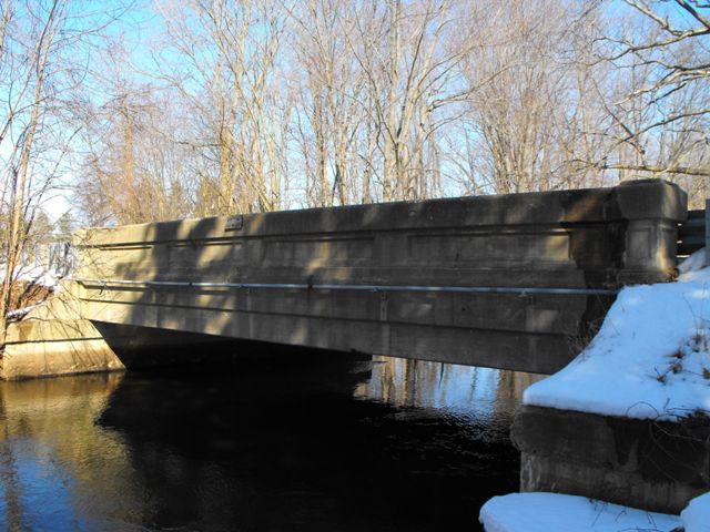
This bridge is a good example of a Michigan concrete through girder bridge. It retains decent historic integrity including the original plaque, but the addition of Armco guardrails are a detriment to the aesthetic qualities of the bridge. The bridge is structurally in decent shape, however the west girder exhibits a gash of spalling that has eroded the bridge beneath the top edge of the girder. The number of surviving concrete girders in Michigan that have decent integrity and no widespread spalling is decreasing; preservation should be considered for the better examples. Despite the spalling on the west girder, the overall structure condition is decent and this would be a bridge worthy of preservation consideration.

The project to completely remove the entire superstructure of this historic bridge and construct a new superstructure, reusing portions of the substructure, is being described as a rehabilitation. This labeling of the project is extremely misleading to the general public and harmful to any effort to promote repair and rehabilitation of existing bridges, whether for goals of sustainability, better fiscal responsibility, or historic preservation. HistoricBridges.org strongly suggests that MDOT and all involved highway agencies reword its policies so that a project that completely demolishes a superstructure be called a partial replacement. This nomenclature has been used in other states, and so HistoricBridges.org is not suggesting something radical or unrealistic. Calling it a rehabilitation implies that preservation is taking place when it in fact is not. The superstructure is the greatest part of the bridge... it is the portion that does the "bridging" of a crossing. The replacement of a superstructure involves the costly and wasteful removal and replacement of a large percentage of a bridge. Remove the superstructure and you have removed the most visible and historically significant part of a bridge. Certainly the substructure is just as important if not more important to the ability of a bridge to function (a failed substructure can destroy a perfect superstructure). But despite that face, reusing a substructure is not enough to constitute a rehabilitation.
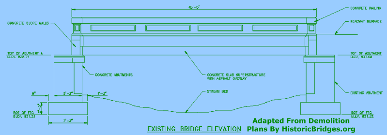
Often, HistoricBridges.org calls attention to the fact that demolition of a historic bridge may occur because the firm an agency hired to study the feasibility of rehabilitation does not have sufficient knowledge of historic bridges to design a good rehabilitation that is both cost-effective and will also result in a long service life. Consider the adapted drawing that HistoricBridges.org has offered for this bridge above. In the case of this particular drawing, HistoricBridges.org acquired the plans for the replacement bridge as provided in the contract bid package by MDOT, and cropped and retouched part of the plans that showed the existing (historic) bridge. HistoricBridges.org did not alter any of the labels in the drawing. That being the case, note that the bridge has been labeled as a concrete slab superstructure and the girders are simply labeled as "railings." Based on all the evidence that HistoricBridges.org has, including the assessment of other bridges nearly identical to this one identified as concrete girder bridges, this assessment is not true. While the deck is likely heavily reinforced, the "railings" are actually load-bearing girders and thus also structurally significant to the design of the bridge. This is not recognized in the contract. Granted, this is a removal project, and maybe it does not matter, but it is still unprofessional and suggests that the engineer does not know a concrete girder when he/she sees one. Also, it could pose a safety hazard to contactors, if the contractor reads the plans and believes they can remove the girders and still expect the deck to support the same amount of weight it could before the girders were removed, which would not be the case.
![]()
Photo Galleries and Videos: Duffield Road Bridge
Bridge Photo-Documentation
Original / Full Size PhotosA collection of overview and detail photos. This gallery offers photos in the highest available resolution and file size in a touch-friendly popup viewer.
Alternatively, Browse Without Using Viewer
![]()
Bridge Photo-Documentation
Mobile Optimized PhotosA collection of overview and detail photos. This gallery features data-friendly, fast-loading photos in a touch-friendly popup viewer.
Alternatively, Browse Without Using Viewer
![]()
Maps and Links: Duffield Road Bridge
This historic bridge has been demolished. This map is shown for reference purposes only.
Coordinates (Latitude, Longitude):
Search For Additional Bridge Listings:
Bridgehunter.com: View listed bridges within 0.5 miles (0.8 kilometers) of this bridge.
Bridgehunter.com: View listed bridges within 10 miles (16 kilometers) of this bridge.
Additional Maps:
Google Streetview (If Available)
GeoHack (Additional Links and Coordinates)
Apple Maps (Via DuckDuckGo Search)
Apple Maps (Apple devices only)
Android: Open Location In Your Map or GPS App
Flickr Gallery (Find Nearby Photos)
Wikimedia Commons (Find Nearby Photos)
Directions Via Sygic For Android
Directions Via Sygic For iOS and Android Dolphin Browser
USGS National Map (United States Only)
Historical USGS Topo Maps (United States Only)
Historic Aerials (United States Only)
CalTopo Maps (United States Only)


