We Recommend:
Bach Steel - Experts at historic truss bridge restoration.
Escanaba Traction Company Bridge

Primary Photographer(s): Nathan Holth
Bridge Documented: October 1, 2012
Railroad (Abandoned Escanaba Traction Company) Over Escanaba River
Escanaba: Delta County, Michigan: United States
By Builder/Contractor: Unknown
Not Available or Not Applicable
Not Available
Not Available
Not Available
Main Span Count Not Available
Not Applicable

View Information About HSR Ratings
Bridge Documentation
This bridge no longer exists!
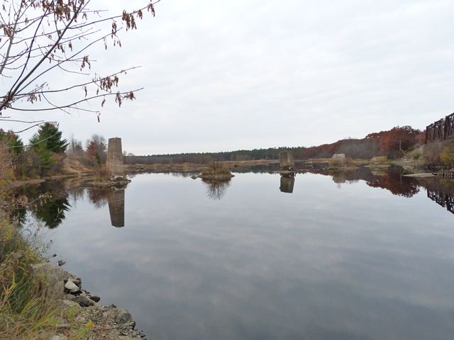
Bridge Status: Only the concrete substructure of this bridge remains!HistoricBridges.org does not typically include the remains of long-lost bridges, except that this bridge helps set the context of this section of the Escanaba River, where the varying remains of at least three bridges can be found in the area. Also, this bridge is of particular interest because it was of unusual design. That the bridge was of unusual design is visible even today, with the entire superstructure and approach system long gone. The remaining concrete piers, all that remains today, are of rapidly changing height indicating a bridge of extremely steep grade (incline). At one end, the bridge was higher than the adjacent railroad bridge. Running at a different angle as the railroad bridge, this bridge's slope carried the deck down and actually under the railroad bridge. This bridge's superstructure was apparently removed, at least partially, by 1943. This can be determined because when the adjacent railroad bridge's five spans were turned into ten spans by adding piers, one of these added piers was placed such that it lies right in the path of where the railroad bridge would have been. The substructure of the bridge today is immensely deteriorated. The worst deterioration is at the base. Some of the piers are tipping. Some of the piers have the wooden piles that form the core of the substructure exposed in these areas, an interesting look at the interior of a concrete pier.
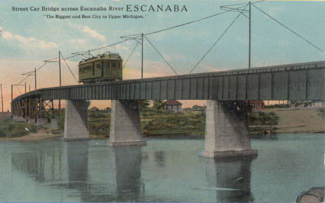
The below post card shows the bridge in its original configuration. Note the additional long approach span system at the far end of the image; this approach system is gone as well.

Image courtesy of the Escanaba Postcard Museum - www.eskycards.com.
![]()
Photo Galleries and Videos: Escanaba Traction Company Bridge
Bridge Photo-Documentation
Original / Full Size PhotosA collection of overview and detail photos. This gallery offers photos in the highest available resolution and file size in a touch-friendly popup viewer.
Alternatively, Browse Without Using Viewer
![]()
Bridge Photo-Documentation
Mobile Optimized PhotosA collection of overview and detail photos. This gallery features data-friendly, fast-loading photos in a touch-friendly popup viewer.
Alternatively, Browse Without Using Viewer
![]()
Maps and Links: Escanaba Traction Company Bridge
This historic bridge has been demolished. This map is shown for reference purposes only.
Coordinates (Latitude, Longitude):
Search For Additional Bridge Listings:
Bridgehunter.com: View listed bridges within 0.5 miles (0.8 kilometers) of this bridge.
Bridgehunter.com: View listed bridges within 10 miles (16 kilometers) of this bridge.
Additional Maps:
Google Streetview (If Available)
GeoHack (Additional Links and Coordinates)
Apple Maps (Via DuckDuckGo Search)
Apple Maps (Apple devices only)
Android: Open Location In Your Map or GPS App
Flickr Gallery (Find Nearby Photos)
Wikimedia Commons (Find Nearby Photos)
Directions Via Sygic For Android
Directions Via Sygic For iOS and Android Dolphin Browser
USGS National Map (United States Only)
Historical USGS Topo Maps (United States Only)
Historic Aerials (United States Only)
CalTopo Maps (United States Only)

