

View Information About HSR Ratings
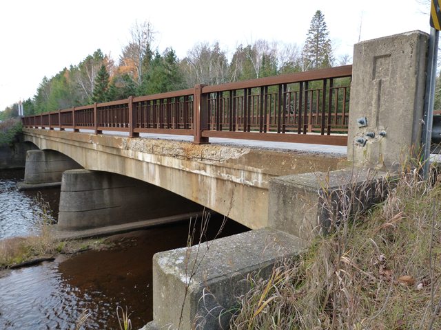
This bridge is a remarkably unaltered example of an early Michigan State Highway Department curved t-beam. The highway department designed a limited number of curved t-beams during the 1940s, but the design found the most widespread use in the late 1950s and early 1960s as expressway overpasses. As such, this is an uncommon example of a curved t-beam that crosses water rather than a highway.
The bridge is also noteworthy for its unusual variation of a common railing design. The bridge has railings that include Michigan's type R4 standard railing panels. The posts for this bridge are unusual however. The typical R4 railing could be built with concrete posts and metal posts. The concrete posts had a keyhole design inset into them, except for the early concrete posts which had a different pattern. In contrast, the metal posts had strips of metal attached to them for decoration. However this bridge is different from those two designs. Instead, it has metal posts, but the metal has an inset keyhole for decoration (similar to the concrete posts) in place of the metal strips.
Delta County is seeking Local Bridge Program funding to rehabilitate this bridge for 2013. HistoricBridges.org applauds this effort, and agrees that rehabilitation is an appropriate course of action for this bridge. However, HistoricBridges.org urges Delta County and MDOT to revise the existing plan to remove and replace the beautiful and unusual railings on this bridge. Instead, the existing railings should be repaired as needed, with crash tested barriers placed in front of the original railings to protect the historic railings and increase bridge safety. There appears to be sufficient space between the curb and the R4 railings to perhaps place an independent set of railings, such as MDOT's two-tube guardrail design.
![]()
![]()
![]()
Coordinates (Latitude, Longitude):
Search For Additional Bridge Listings:
Bridgehunter.com: View listed bridges within 0.5 miles (0.8 kilometers) of this bridge.
Bridgehunter.com: View listed bridges within 10 miles (16 kilometers) of this bridge.
Additional Maps:
Google Streetview (If Available)
GeoHack (Additional Links and Coordinates)
Apple Maps (Via DuckDuckGo Search)
Apple Maps (Apple devices only)
Android: Open Location In Your Map or GPS App
Flickr Gallery (Find Nearby Photos)
Wikimedia Commons (Find Nearby Photos)
Directions Via Sygic For Android
Directions Via Sygic For iOS and Android Dolphin Browser
USGS National Map (United States Only)
Historical USGS Topo Maps (United States Only)
Historic Aerials (United States Only)
CalTopo Maps (United States Only)

© Copyright 2003-2024, HistoricBridges.org. All Rights Reserved. Disclaimer: HistoricBridges.org is a volunteer group of private citizens. HistoricBridges.org is NOT a government agency, does not represent or work with any governmental agencies, nor is it in any way associated with any government agency or any non-profit organization. While we strive for accuracy in our factual content, HistoricBridges.org offers no guarantee of accuracy. Information is provided "as is" without warranty of any kind, either expressed or implied. Information could include technical inaccuracies or errors of omission. Opinions and commentary are the opinions of the respective HistoricBridges.org member who made them and do not necessarily represent the views of anyone else, including any outside photographers whose images may appear on the page in which the commentary appears. HistoricBridges.org does not bear any responsibility for any consequences resulting from the use of this or any other HistoricBridges.org information. Owners and users of bridges have the responsibility of correctly following all applicable laws, rules, and regulations, regardless of any HistoricBridges.org information.
![]()