

View Information About HSR Ratings
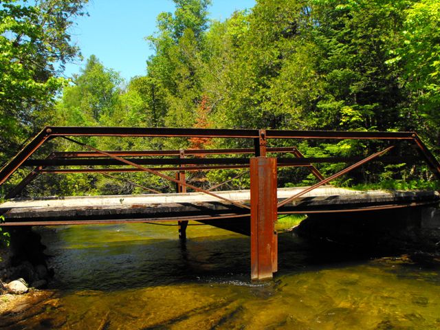
This bridge was originally known as East Townline Bridge. Recently it also had yet another nickname of simply Old Iron Bridge. www.oldironbridge.com had this bridge listed as a King Bridge Company structure, but it is unclear where that came from, as their is no plaque for the bridge. The plans on their website do not appear to match this structure. Either way, although this is a small bridge overall, for a two-panel half-hip Pratt pony, it is quite long. In other words, the panel size is above average. The bridge no longer functions as a truss bridge, because a pier support has been added in the center. The bridge today functions as a steel stringer, with only the deck stringers supporting the deck, and in the national bridge inventory actually shows up as a metal stringer. However, the bridge is still an attractive crossing, and was the subject of attempts at preservation made a few years ago. The bridge was apparently going to be abandoned and turned over to private ownership. No actual work was ever done on the structure however.
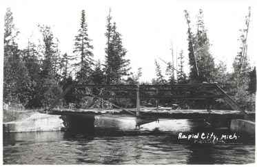
Above: Joseph Mariage's photo shows the bridge in 1915-1920. Obviously, the pier had not been added at this time. The bridge was a new structure when this photo was taken. The photo is described on the oldironbridge.com website as follows:
"The bridge was a major thru-way for the residents of Clearwater Township and pioneers from the north until the bridges were built in town and west of this bridge at Kellogg Road. Eventually, the Glade Valley Road became dead-ended north of the bridge because of lack of use."
![]()
![]()
![]()
Coordinates (Latitude, Longitude):
Search For Additional Bridge Listings:
Bridgehunter.com: View listed bridges within 0.5 miles (0.8 kilometers) of this bridge.
Bridgehunter.com: View listed bridges within 10 miles (16 kilometers) of this bridge.
Additional Maps:
Google Streetview (If Available)
GeoHack (Additional Links and Coordinates)
Apple Maps (Via DuckDuckGo Search)
Apple Maps (Apple devices only)
Android: Open Location In Your Map or GPS App
Flickr Gallery (Find Nearby Photos)
Wikimedia Commons (Find Nearby Photos)
Directions Via Sygic For Android
Directions Via Sygic For iOS and Android Dolphin Browser
USGS National Map (United States Only)
Historical USGS Topo Maps (United States Only)
Historic Aerials (United States Only)
CalTopo Maps (United States Only)

© Copyright 2003-2024, HistoricBridges.org. All Rights Reserved. Disclaimer: HistoricBridges.org is a volunteer group of private citizens. HistoricBridges.org is NOT a government agency, does not represent or work with any governmental agencies, nor is it in any way associated with any government agency or any non-profit organization. While we strive for accuracy in our factual content, HistoricBridges.org offers no guarantee of accuracy. Information is provided "as is" without warranty of any kind, either expressed or implied. Information could include technical inaccuracies or errors of omission. Opinions and commentary are the opinions of the respective HistoricBridges.org member who made them and do not necessarily represent the views of anyone else, including any outside photographers whose images may appear on the page in which the commentary appears. HistoricBridges.org does not bear any responsibility for any consequences resulting from the use of this or any other HistoricBridges.org information. Owners and users of bridges have the responsibility of correctly following all applicable laws, rules, and regulations, regardless of any HistoricBridges.org information.
![]()