

View Information About HSR Ratings
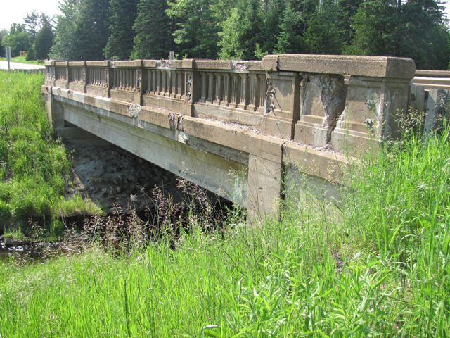
This bridge is one of the oldest examples of a steel stringer bridge in Michigan with concrete balustrade railings. Unlike the numerous examples built from 1927 to 1932, this 1926 example encases all the stringers in concrete rather than just the outside of the outermost "fascia" beams. This bridge also uses built-up beams rather than the more common rolled beams. This bridge is essentially a prototype of the design Michigan built for the next five years, and it is thus significant because it documents the development of this prolific standard plan.
Information and Findings From Michigan Historic Sites OnlineNarrative Description main span number: 1 main span length: 55.0 structure length: 55.0 roadway width: 30.0 structure width: 35.0 Located on M-28, about a mile southeast of the village of Strongs, this single-span concrete/steel bridge crosses the East Branch of the Tahquamenon River. The structure is configured as a 55-foot steel deck girder bridge, with nine lines of built-up I-beams encased in concrete. These are braced laterally by concrete diaphragms and supported simply by massive concrete abutments with straight wingwalls. The girders carry a concrete deck, which has been surfaced with asphalt. This deck is bounded on both sides by SHD standard concrete guardrails with classical fluted balusters and paneled bulkheads. Other than the installation of Armco beams inside the original guardrails, the Tahquamenon River Bridge remains essentially unaltered and in excellent condition. Statement of Significance Trunk Line 25 (M-28) which extends west from Sault Ste. Marie to an intersection with Trunk Line 15 south of Marquette, has been improved by construction of several miles of gravel road through Schoolcraft, Luce and Chippewa Counties," The SHD reported in 1926. "The completion of the work on Trunk Line 25 furnishes a northerly route for east and west traffic across the Upper Peninsula." Part of the improvement to the road was the construction of a new bridge over the Tahquamenon River near Strongs. SHD engineers delineated the new structure in 1926. Funding the project with Federal Aid money, the agency solicited bids for the bridge's construction and awarded the contract to Walter Toebe and Company of Shingleton. Toebe built the bridge in 1926 for a total cost of $24,286.08. Since its completion, the Tahquamenon River Bridge has carried vehicular traffic, in relatively unaltered condition. The structural type that SHD delineated for this bridge was one that the agency had only recently begun using. The highway department had developed a standard design for a steel stringer bridge as early as the 1905-1906 biennium and for a steel plate girder two years later. Additionally, SHD had begun encasing the stringers partially in the concrete as part of the deck in the 1905-1906 biennium. But it was not until about 1926 that SHD engineers began encasing the webs of steel girders in concrete. The purpose for this is unclear. The concrete does not appear to add structural strength to the beams, and concrete diaphragms are still employed to brace them laterally. SHD illustrated the new configuration in its Twelfth Biennial Report with a photo of a bridge over the Maple River on US-27 (since demolished), describing it as "one of the latest types of encased girder design." SHD soon discontinued wrapping the interior girders in concrete, limiting the concrete to the exterior spandrel walls. The Tahquamenon River Bridge is one of only two such encased girders identified by survey sample. It is thus noteworthy as a formative exercise in what would evolve into a state standard design. Carrying a regionally important route over a major watercourse, it is both historically and technologically significant- an important transportation related resource. |
![]()
![]()
![]()
Coordinates (Latitude, Longitude):
Search For Additional Bridge Listings:
Bridgehunter.com: View listed bridges within 0.5 miles (0.8 kilometers) of this bridge.
Bridgehunter.com: View listed bridges within 10 miles (16 kilometers) of this bridge.
Additional Maps:
Google Streetview (If Available)
GeoHack (Additional Links and Coordinates)
Apple Maps (Via DuckDuckGo Search)
Apple Maps (Apple devices only)
Android: Open Location In Your Map or GPS App
Flickr Gallery (Find Nearby Photos)
Wikimedia Commons (Find Nearby Photos)
Directions Via Sygic For Android
Directions Via Sygic For iOS and Android Dolphin Browser
USGS National Map (United States Only)
Historical USGS Topo Maps (United States Only)
Historic Aerials (United States Only)
CalTopo Maps (United States Only)

© Copyright 2003-2024, HistoricBridges.org. All Rights Reserved. Disclaimer: HistoricBridges.org is a volunteer group of private citizens. HistoricBridges.org is NOT a government agency, does not represent or work with any governmental agencies, nor is it in any way associated with any government agency or any non-profit organization. While we strive for accuracy in our factual content, HistoricBridges.org offers no guarantee of accuracy. Information is provided "as is" without warranty of any kind, either expressed or implied. Information could include technical inaccuracies or errors of omission. Opinions and commentary are the opinions of the respective HistoricBridges.org member who made them and do not necessarily represent the views of anyone else, including any outside photographers whose images may appear on the page in which the commentary appears. HistoricBridges.org does not bear any responsibility for any consequences resulting from the use of this or any other HistoricBridges.org information. Owners and users of bridges have the responsibility of correctly following all applicable laws, rules, and regulations, regardless of any HistoricBridges.org information.
![]()