

View Information About HSR Ratings
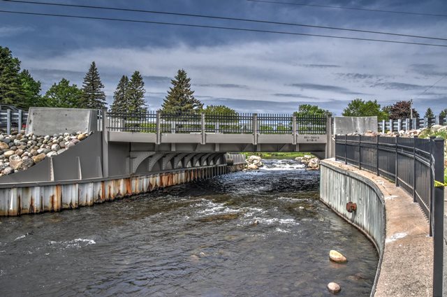
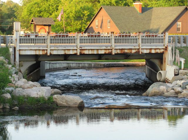
This bridge is the only example of a steel rigid-frame bridge in Michigan. Rigid-frame bridges are most commonly concrete. Concrete rigid frame bridges were common in some places like the province of Ontario, but they are rare in Michigan. Steel rigid-frame bridges, at least those of a historic age, are rare anywhere. Most examples of steel rigid-frame bridges are in early limited access highway overpasses such as Lake Shore Drive in Chicago or the Merritt Parkway in Connecticut. This Michigan example is in comparison a very small crossing over a river.
The bridge has a Michigan State Highway Department standard railing design that was very sparingly used across the state. Surviving bridges with this unusual metal railing design are quite rare.
This bridge is located in Crawford County, a county that is noted for its striking lack of historic bridges.
MDOT reports the contractor for the bridge as "F. G. Atelwed" however no evidence of a contractor by that name (or anyone for that matter) appears to have existed. It is far more likely that this is a typo on MDOT's part and that the contractor was the similarly named F. C. Atletwed a known bridge contractor in Michigan.
Information and Findings From Michigan Historic Sites OnlineNarrative Description One of the two Crawford County structures in the Survey Sample is this short-span steel bridge in the city of Grayling. The Grayling Bridge carries BL-75/M-72 over the Au Sable River in the middle of the city's central business district. The bridge is a 40-foot, steel stringer structure, featuring nine lines of rolled I-beams that carry the concrete roadway and flanking sidewalks. The stringers are supported by riveted steel brackets that cantilever from the steel plates over sheet piling abutments. These abutments are flanked by angled concrete wingwalls. Although listed as a simply supported structure in the MDOT Bridge Database, the Grayling Bridge is in actuality a rigid-frame structure, with the superstructure secured rigidly to the abutments by means of the arched brackets. Architectural expression for the otherwise plain-faced bridge is provided by the ornamental steel guardrails. Other than the installation of Armco guardrails inside the original rails, the Grayling Bridge remains in unaltered and physically good condition. main span number: 1 main span length: 40.0 structure length: 40.0 roadway width: 42.0 structure width: 53.0 Statement of Significance The village of Grayling, Crawford County's only incorporated city, was first platted in 1874 by the Saginaw & Jackson Railroad. Named after the grayling trout, which populated the Au Sable River in abundance, the settlement was incorporated as a village in 1903 and as a city in 1935. Flowing through the center of town, the Au Sable River had historically formed the major impediment to travel between the town's two sides. The first bridge was built across the Au Sable here soon after the village's platting in the 19th century. But population growth after 1900 and the designation of a state trunk line through town in 1913 placed additional strain on the existing bridge. By the late 1910s the village had begun to consider a replacement span for the State Street Bridge. In 1921 Walmer Jorgensen was hired to build a new concrete span here. Completed the following year, the bridge carried increasingly heavy vehicular traffic through the 1920s, but by the early 1930s, it had again become an impediment to travel. The road had by then been designated M-72, and the state highway department engineered the replacement span in 1933. For the new Grayling Bridge, SHD delineated a steel rigid-frame structure. The rigid-frame configuration had been used nationally in the 1930s, primarily on federally funded urban bridge and grade separation projects. The Michigan State Highway Department had only begun using rigid-frame bridges in the mid-1930s, relying almost exclusively on the concrete rigid frame; SHD adopted neither the concrete nor steel rigid-frame as a standard design. Developed as a special design in 1933, the Grayling Bridge was designated a Federal Aid project, and contractor F. G. Atelwed was hired to build it. The structure was opened in the summer of 1935 at a cost of $13,700. It has since carried vehicular traffic in almost unaltered condition. Perhaps the first steel rigid-frame bridge built by SHD, the Grayling Bridge is today technologically significant as a developmental design exercise by the agency. It is the only SHD-design, rigid-frame steel span identification by the Survey Sample. The historic focal point of Vehicular traffic in this small city, the Grayling Bridge is eligible for the National Register of Historic Places. |
This bridge is tagged with the following special condition(s): Unorganized Photos
![]()
![]()
![]()
![]()
![]()
Coordinates (Latitude, Longitude):
Search For Additional Bridge Listings:
Bridgehunter.com: View listed bridges within 0.5 miles (0.8 kilometers) of this bridge.
Bridgehunter.com: View listed bridges within 10 miles (16 kilometers) of this bridge.
Additional Maps:
Google Streetview (If Available)
GeoHack (Additional Links and Coordinates)
Apple Maps (Via DuckDuckGo Search)
Apple Maps (Apple devices only)
Android: Open Location In Your Map or GPS App
Flickr Gallery (Find Nearby Photos)
Wikimedia Commons (Find Nearby Photos)
Directions Via Sygic For Android
Directions Via Sygic For iOS and Android Dolphin Browser
USGS National Map (United States Only)
Historical USGS Topo Maps (United States Only)
Historic Aerials (United States Only)
CalTopo Maps (United States Only)

© Copyright 2003-2024, HistoricBridges.org. All Rights Reserved. Disclaimer: HistoricBridges.org is a volunteer group of private citizens. HistoricBridges.org is NOT a government agency, does not represent or work with any governmental agencies, nor is it in any way associated with any government agency or any non-profit organization. While we strive for accuracy in our factual content, HistoricBridges.org offers no guarantee of accuracy. Information is provided "as is" without warranty of any kind, either expressed or implied. Information could include technical inaccuracies or errors of omission. Opinions and commentary are the opinions of the respective HistoricBridges.org member who made them and do not necessarily represent the views of anyone else, including any outside photographers whose images may appear on the page in which the commentary appears. HistoricBridges.org does not bear any responsibility for any consequences resulting from the use of this or any other HistoricBridges.org information. Owners and users of bridges have the responsibility of correctly following all applicable laws, rules, and regulations, regardless of any HistoricBridges.org information.
![]()