

View Information About HSR Ratings
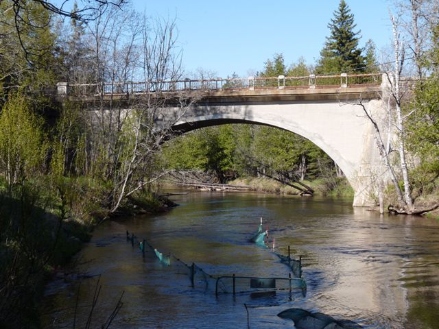
The Mackinac Trail Bridge is the oldest surviving bridge in Mackinac County. It is also a rare surviving example of an early Michigan State Highway Department concrete arch bridge. This bridge has an unusual history because less than a decade after it was built, the bridge was rehabilitated and widened by cantilevering the deck slightly, to accommodate the increased traffic anticipated when US-2 was designated to run on Mackinac Trail. The original guardrail system was replaced at this time with an extremely unusual guardrail that the Historic Bridge Inventory comments is a standard plan design. Even though it may be a standard plan design guardrail, the design was either never used often or all other examples have been demolished, because the design appears to be the only example remaining today. While the widening and guardrail replacement is an alteration from the original bridge design, the alteration itself is so old and was done so soon after the bridge was first built that these changes are considered historically significant as well.
In addition to its historic significance, the bridge is an attractive structure and has aesthetic value as well. The guardrails on the bridge have a pleasing (and today unique) design to them. In addition, the cantilevering of the deck was done in a tasteful manner and there are architectural details that were incorporated on the arch and cantilever section. There are also attractive stone retaining walls that were added leading up to the bridge when it was widened.
This bridge has since been rehabilitated. Unfortunately however, the unusual railings that were on this bridge was removed and replaced with standard modern guardrail.
Information and Findings From Michigan Historic Sites OnlineNarrative Description Main span number is 1. Main span length is 60 feet. Structure length is 60 feet. Roadway width is 22.5 feet. Structure width is 26 feet. Located some eleven miles north of St. Ignace, this graceful concrete arch bridge spans the Carp River on the Mackinac Trail. The crossing is situated immediately west of I-75, about a mile from the river's mouth at St. Martin Bay. The structure is comprised of a 60-foot, filled spandrel arch, with an elliptical profile. The arch springs from massive concrete abutments, which feature battered backwalls and angled wingwalls. Cobblestone retaining walls are built above the wingwalls at the approaches. The tapered arch ring of the Carp River Bridge is corbelled from the spandrel on each side. This, and the MSHD standard guardrail, originally provided the bridge's architectural expression. The original guardrails have since been removed, however, and the deck widened by cantilevering slightly over the spandrel walls to form concrete stringcourses. The existing guardrails are also MSHD standard, this time with ornamental steel rails and concrete bulkheads. This alteration marks the most serious loss of physical integrity for the bridge. The only other change is minor: the bridge plate that was bolted to the guardrail when the bridge was inventoried in 1982 has since been stolen. Statement of Significance Soon after the legislature passed the State Trunk Line Act in 1913, authorizing the formation of a trunk line system of roads, a route began to form through Mackinac and Chippewa counties that would link the straits of Mackinac at the southern tip of the Upper Peninsula with Sault Ste. Marie on the Canadian border. Improvement work began first in 1913-1914 on the southernmost segment, from St. Ignace north to a point just beyond Rogers Park, south fo the Carp River Crossing. A major Upper Peninsula artery, the Mackinac Trail was extended to Sault Ste. Marie in the 1910s. Its construction entailed both roadway grading and bridge construction. One of these latter structures spanned the Carp River Mackinac County about midway between the Straits and the Chippewa County line. For this crossing, engineers of the Michigan State Highway Department delineated a 60-foot concrete arch in 1919. MSHD hired Flint contractor A.S. Decker to build the bridge. "The 60 ft. span Arch over the Carp River in St. Ignace Township of Mackinac County has just been completed, "MSHD reported in the summer of 1920. Total cost for the bridge and adjacent roadway grading: $41,223.53. Later incorporated into US-2, the structure carried increasingly heavy traffic, prompting MSHD to widen its deck by five feet and install new guardrails in the 1929-1930 biennium. Decorative cobblestone retaining walls were built at the approaches at that time. This segment of the Mackinac Trail is now a county road, superseded by I-75. Still, the Carp River Bridge carries local vehicular traffic without further alteration. State highway department engineers began designing concrete arch bridges as early as 1908, but, unlike its practice on other structural types, the agency did not develop a standard concrete arch design. The bearing and superstructural conditions were too site specific, MSHD rationalized, making standardization of concrete arches impractical. Instead, the highway department used special-design concrete arches up to 80-feet in length "wherever it is possible to secure sufficiently hard foundations, and also where there is clearance enough for water to flow freely without the arch choking the stream too much", according to its Seventh Biennial Report. In 1914 MSHD built its first state arch for Trunk Line Bridge NO. 3 - a 50-foot span over Paint Creek in Kent County. As the trunk line system developed in the 1910s, MSHD built several more arches. By 1918 the agency had constructed twelve trunk line arches, ranging in span from 35 to 85 feet. Built in 1919-1920, the Carp River Bridge falls within this statewide construction trend. It is today distinguished as one of the few remaining arches from MSHD's earliest period: a handsomely proportioned exercise in highway bridge design. Although altered by the installation of a new guardrail, this alteration occurred within the bridge's historic period and has thus become a part of the structure's history. Built as an integral, formative part of one of the Upper Peninsula's most important routes, the Carp River Bridge is a significant transportation-related resource. |
![]()
![]()
![]()
Coordinates (Latitude, Longitude):
Search For Additional Bridge Listings:
Bridgehunter.com: View listed bridges within 0.5 miles (0.8 kilometers) of this bridge.
Bridgehunter.com: View listed bridges within 10 miles (16 kilometers) of this bridge.
Additional Maps:
Google Streetview (If Available)
GeoHack (Additional Links and Coordinates)
Apple Maps (Via DuckDuckGo Search)
Apple Maps (Apple devices only)
Android: Open Location In Your Map or GPS App
Flickr Gallery (Find Nearby Photos)
Wikimedia Commons (Find Nearby Photos)
Directions Via Sygic For Android
Directions Via Sygic For iOS and Android Dolphin Browser
USGS National Map (United States Only)
Historical USGS Topo Maps (United States Only)
Historic Aerials (United States Only)
CalTopo Maps (United States Only)

© Copyright 2003-2024, HistoricBridges.org. All Rights Reserved. Disclaimer: HistoricBridges.org is a volunteer group of private citizens. HistoricBridges.org is NOT a government agency, does not represent or work with any governmental agencies, nor is it in any way associated with any government agency or any non-profit organization. While we strive for accuracy in our factual content, HistoricBridges.org offers no guarantee of accuracy. Information is provided "as is" without warranty of any kind, either expressed or implied. Information could include technical inaccuracies or errors of omission. Opinions and commentary are the opinions of the respective HistoricBridges.org member who made them and do not necessarily represent the views of anyone else, including any outside photographers whose images may appear on the page in which the commentary appears. HistoricBridges.org does not bear any responsibility for any consequences resulting from the use of this or any other HistoricBridges.org information. Owners and users of bridges have the responsibility of correctly following all applicable laws, rules, and regulations, regardless of any HistoricBridges.org information.
![]()