

View Information About HSR Ratings
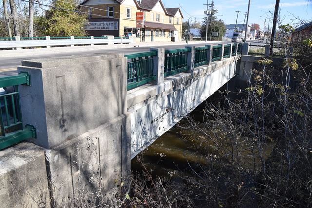
This is a highly unusual steel stringer bridge due to its 70 foot span length which exceeds 60 feet, resulting in uncommon riveted built-up beams. If you ever look up steel stringers you may notice that a lot of steel stringer bridges have a 60 foot span, but spans over 60 feet are less common. There is a reason for this. 60 feet was (and is) typically the longest steel beam that a steel mill will roll during normal operations. This means that any steel stringer bridges that need a span length longer than 60 feet tend to be fabricated (built-up) using rivets, bolts, or welds. A built-up beam is more expensive since it requires fabrication so this increases the economy of using shorter spans and piers rather than a longer clear span. However in some cases (with small river bridges like this, that could be due to water flow/flood concerns or soil conditions) a longer span may be required regardless. What is unclear is why a longer span (and only ten feet longer than 60 feet) was needed here. It does not appear to be for water flow, otherwise the abandoned concrete pier from another long-lost bridge that is right next to this bridge would have been removed. Because this bridge required the extra step of beam fabrication, the prime contractor, Joseph Plozai, Inc. of Detroit, Michigan elected to subcontract the beam fabrication to the American Bridge Company who hid one of their standard builder plaques at the end of one of the beams, in addition to the standard highway department plaque mounted on the railing.
In 2020 this bridge was repainted which is good, but sadly Armco guardrail was added on top of the attractive R4 railing. It would have been nice to see curb-mounted two-tube guardrail added on the sidewalk side of the bridge at least, for increased pedestrian safety, and unobstructred view of the attractive railing for pedestrians crossing the bridge.
This bridge and road is today under local control, but this used to be a state trunkline, M-120, which is why the main plaque does not mention the city or county.
![]()
![]()
![]()
Coordinates (Latitude, Longitude):
Search For Additional Bridge Listings:
Bridgehunter.com: View listed bridges within 0.5 miles (0.8 kilometers) of this bridge.
Bridgehunter.com: View listed bridges within 10 miles (16 kilometers) of this bridge.
Additional Maps:
Google Streetview (If Available)
GeoHack (Additional Links and Coordinates)
Apple Maps (Via DuckDuckGo Search)
Apple Maps (Apple devices only)
Android: Open Location In Your Map or GPS App
Flickr Gallery (Find Nearby Photos)
Wikimedia Commons (Find Nearby Photos)
Directions Via Sygic For Android
Directions Via Sygic For iOS and Android Dolphin Browser
USGS National Map (United States Only)
Historical USGS Topo Maps (United States Only)
Historic Aerials (United States Only)
CalTopo Maps (United States Only)

© Copyright 2003-2024, HistoricBridges.org. All Rights Reserved. Disclaimer: HistoricBridges.org is a volunteer group of private citizens. HistoricBridges.org is NOT a government agency, does not represent or work with any governmental agencies, nor is it in any way associated with any government agency or any non-profit organization. While we strive for accuracy in our factual content, HistoricBridges.org offers no guarantee of accuracy. Information is provided "as is" without warranty of any kind, either expressed or implied. Information could include technical inaccuracies or errors of omission. Opinions and commentary are the opinions of the respective HistoricBridges.org member who made them and do not necessarily represent the views of anyone else, including any outside photographers whose images may appear on the page in which the commentary appears. HistoricBridges.org does not bear any responsibility for any consequences resulting from the use of this or any other HistoricBridges.org information. Owners and users of bridges have the responsibility of correctly following all applicable laws, rules, and regulations, regardless of any HistoricBridges.org information.
![]()