

View Information About HSR Ratings
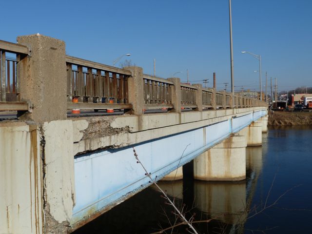
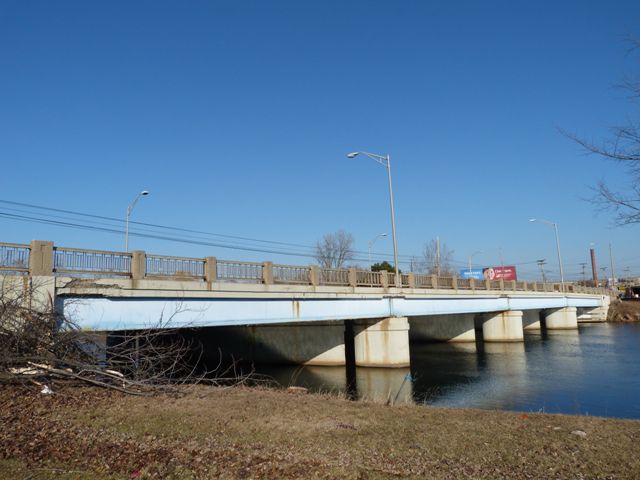
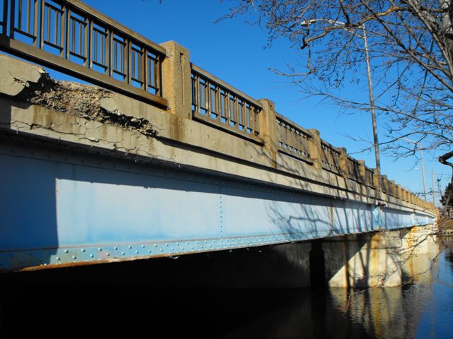
This bridge was built in 1928, but it was widened by adding a few stringers to each side of the bridge in 1957, with Michigan's signature R4 type railings being added to the bridge at that time. The bridge is interesting because great care appears to have been taken to make the widened elements under the bridge resemble the original 1928 elements. Whether this was done for engineering or aesthetic reasons is unclear. When viewed from the top the bridge appears to be a 1957 bridge. When viewed from below, more interesting details are visible. Smaller piers added in 1957 to hold the extra stringers are separate from the large central pier under the bridge. All the piers have the same style and detailing. Most interestingly, the 1957 stringers that were added appear to have been fabricated to the 1928 specifications because they are riveted built-up i-beams just like the 1928 beams. One might have expected the 1957 i-beams to have been rolled instead of built-up. The only difference between the 1957 stringers and the 1928 stringers is that the 1928 stringers have the traditional concrete diaphragms which were in use by the Michigan State Highway Department at that time, while the 1957 stringers have riveted plates for diaphragms.
The bridge is an altered structure, however because the alterations are over 50 years old themselves and were executed in a tasteful manner, this bridge can be considered to have some historic value both as a 1928 bridge and a 1957 bridge. Aesthetically, the R4 railings and the riveted stringers make the bridge is an attractive example of an otherwise mundane structure type.
![]()
![]()
![]()
![]()
![]()

![]()
![]()
This historic bridge has been demolished. This map is shown for reference purposes only.
Coordinates (Latitude, Longitude):
Search For Additional Bridge Listings:
Bridgehunter.com: View listed bridges within 0.5 miles (0.8 kilometers) of this bridge.
Bridgehunter.com: View listed bridges within 10 miles (16 kilometers) of this bridge.
Additional Maps:
Google Streetview (If Available)
GeoHack (Additional Links and Coordinates)
Apple Maps (Via DuckDuckGo Search)
Apple Maps (Apple devices only)
Android: Open Location In Your Map or GPS App
Flickr Gallery (Find Nearby Photos)
Wikimedia Commons (Find Nearby Photos)
Directions Via Sygic For Android
Directions Via Sygic For iOS and Android Dolphin Browser
USGS National Map (United States Only)
Historical USGS Topo Maps (United States Only)
Historic Aerials (United States Only)
CalTopo Maps (United States Only)

© Copyright 2003-2024, HistoricBridges.org. All Rights Reserved. Disclaimer: HistoricBridges.org is a volunteer group of private citizens. HistoricBridges.org is NOT a government agency, does not represent or work with any governmental agencies, nor is it in any way associated with any government agency or any non-profit organization. While we strive for accuracy in our factual content, HistoricBridges.org offers no guarantee of accuracy. Information is provided "as is" without warranty of any kind, either expressed or implied. Information could include technical inaccuracies or errors of omission. Opinions and commentary are the opinions of the respective HistoricBridges.org member who made them and do not necessarily represent the views of anyone else, including any outside photographers whose images may appear on the page in which the commentary appears. HistoricBridges.org does not bear any responsibility for any consequences resulting from the use of this or any other HistoricBridges.org information. Owners and users of bridges have the responsibility of correctly following all applicable laws, rules, and regulations, regardless of any HistoricBridges.org information.
![]()