

View Information About HSR Ratings
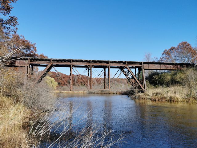
This bridge's main span came from the structure that preceded the current Grand Ledge Railroad Bridge. Peter Schierloh, who visited the bridge, explains below:
I have a set of plans for the 1887 Grand Ledge bridge that was sent to me by the railroad that currently runs over the Stronach Bridge. The 1887 bridge shown in the plans has the same configuration as the current bridge in Grand Ledge with three deck truss spans resting on steel towers, and deck girder approach spans. I suspect the stone piers and abutments at Grand Ledge probably date back to the original 1887 bridge. The Pere Marquette must have replaced the original 1887 iron spans with new riveted steel spans at Grand Ledge sometime prior to 1909. According to the plans I have, they took one of the three 1887 pinned trusses, and the two deck girder spans and moved them to Stronach in 1909. Included in the plans are drawings of a series of modifications (mainly strengthening of the lateral bracing and replacement of the floor system on the truss) made by King Bridge Company in April of 1909. There is no mention what happened to the other two trusses.
Mr. Schierloh was contracted to do repair work on this bridge, which suggests that CSX plans to continue using the rail line and bridge for the foreseeable future.
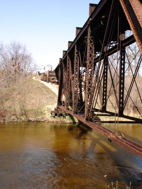
The bridge features v-lacing on the verticals, and deck plate girder approach spans. The bridge's supports and abutments are wooden.
This bridge is tagged with the following special condition(s): Unorganized Photos
![]()
![]()
![]()
![]()
Coordinates (Latitude, Longitude):
Search For Additional Bridge Listings:
Bridgehunter.com: View listed bridges within 0.5 miles (0.8 kilometers) of this bridge.
Bridgehunter.com: View listed bridges within 10 miles (16 kilometers) of this bridge.
Additional Maps:
Google Streetview (If Available)
GeoHack (Additional Links and Coordinates)
Apple Maps (Via DuckDuckGo Search)
Apple Maps (Apple devices only)
Android: Open Location In Your Map or GPS App
Flickr Gallery (Find Nearby Photos)
Wikimedia Commons (Find Nearby Photos)
Directions Via Sygic For Android
Directions Via Sygic For iOS and Android Dolphin Browser
USGS National Map (United States Only)
Historical USGS Topo Maps (United States Only)
Historic Aerials (United States Only)
CalTopo Maps (United States Only)

© Copyright 2003-2024, HistoricBridges.org. All Rights Reserved. Disclaimer: HistoricBridges.org is a volunteer group of private citizens. HistoricBridges.org is NOT a government agency, does not represent or work with any governmental agencies, nor is it in any way associated with any government agency or any non-profit organization. While we strive for accuracy in our factual content, HistoricBridges.org offers no guarantee of accuracy. Information is provided "as is" without warranty of any kind, either expressed or implied. Information could include technical inaccuracies or errors of omission. Opinions and commentary are the opinions of the respective HistoricBridges.org member who made them and do not necessarily represent the views of anyone else, including any outside photographers whose images may appear on the page in which the commentary appears. HistoricBridges.org does not bear any responsibility for any consequences resulting from the use of this or any other HistoricBridges.org information. Owners and users of bridges have the responsibility of correctly following all applicable laws, rules, and regulations, regardless of any HistoricBridges.org information.
![]()