

View Information About HSR Ratings

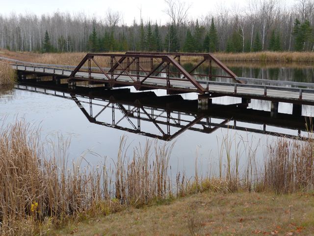
This bridge originally was located in Spalding, Michigan in Menominee County. It carried Old US-41, which was also cosigned with US-2, over the Big Cedar River. The bridge was replaced in 1995. At the time, the Historic American Engineering Record documented the bridge. At this time, the bridge was planned to be moved to Chassell, Michigan to be used as a pedestrian bridge across the Pike River, which would have prevented the demolition of this bridge as part of the replacement project. However, this plan apparently fell through at some point, which might have put the bridge at risk for demolition again. However, the Sweetgrass Golf Club acquired the bridge and moved it onto its golf course, saving the bridge from demolition. Today, the bridge is one of the most visually prominent of the golf course's five historic metal truss bridges. It is the largest central span of a waterway crossing on the course. The approach spans of this crossing are a wooden causeway. The positioning of this bridge as a central span in a causeway helps make the bridge visually prominent and easy to view. The surrounding topography of the course also enables nice elevated views of the bridge from the southwest quadrant around the bridge. The bridge is located near Hole 17 on the course.
This bridge is a fairly uncommon example of its type in Michigan. Compared to other states, few truss bridges were built in Michigan after 1915. With its full slope end posts, the bridge's visual geometry has a neat and orderly appearance to it. All parts of the bridge assembled in the shop use fasters for rivets. However, the parts that had to be put together in the field were bolted instead, likely to avoid the need to use field riveting. This is unusual because in 1918, field riveting was readily available. The use of bolted connections was not common until the second half of the 20th Century, when bolted connections became preferred over riveted connections. At the time this bridge was built, all-riveted connections would have been the standard. As such, this bridge is an early example of a rigid-connected truss bridge with bolted connections instead of riveted connections.

![]()
![]()
![]()
This bridge is located on a golf course and is private property, open to golf course users only.
Coordinates (Latitude, Longitude):
Search For Additional Bridge Listings:
Bridgehunter.com: View listed bridges within 0.5 miles (0.8 kilometers) of this bridge.
Bridgehunter.com: View listed bridges within 10 miles (16 kilometers) of this bridge.
Additional Maps:
Google Streetview (If Available)
GeoHack (Additional Links and Coordinates)
Apple Maps (Via DuckDuckGo Search)
Apple Maps (Apple devices only)
Android: Open Location In Your Map or GPS App
Flickr Gallery (Find Nearby Photos)
Wikimedia Commons (Find Nearby Photos)
Directions Via Sygic For Android
Directions Via Sygic For iOS and Android Dolphin Browser
USGS National Map (United States Only)
Historical USGS Topo Maps (United States Only)
Historic Aerials (United States Only)
CalTopo Maps (United States Only)

© Copyright 2003-2024, HistoricBridges.org. All Rights Reserved. Disclaimer: HistoricBridges.org is a volunteer group of private citizens. HistoricBridges.org is NOT a government agency, does not represent or work with any governmental agencies, nor is it in any way associated with any government agency or any non-profit organization. While we strive for accuracy in our factual content, HistoricBridges.org offers no guarantee of accuracy. Information is provided "as is" without warranty of any kind, either expressed or implied. Information could include technical inaccuracies or errors of omission. Opinions and commentary are the opinions of the respective HistoricBridges.org member who made them and do not necessarily represent the views of anyone else, including any outside photographers whose images may appear on the page in which the commentary appears. HistoricBridges.org does not bear any responsibility for any consequences resulting from the use of this or any other HistoricBridges.org information. Owners and users of bridges have the responsibility of correctly following all applicable laws, rules, and regulations, regardless of any HistoricBridges.org information.
![]()