

View Information About HSR Ratings
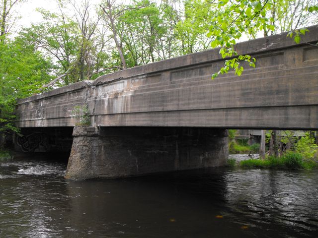
This bridge is an extremely rare example of a multi-span concrete through girder in Michigan. The bridge has been abandoned for many years and although overgrown, retains excellent historic integrity.
This bridge likely dates to somewhere in the 1920s. What is unusual is that the current highway bridge and highway alignment that carries Telegraph Road (US-24) just east of this bridge is listed in the National Bridge Inventory as having been originally built in 1931. This girder bridge would have been very new at that time. It is unclear what the exact history at this location is. However it appears that perhaps beginning in 1931 with the construction of the bridge east of this girder bridge, that the split of US-24 (Telegraph Road) and Monroe Street (M-125) was located a short distance north of Stony Creek, with US-24/Telegraph Road crossing Stony Creek on the girder bridge and M-125 crossing Stony Creek on the 1931 bridge. If this assumption is correct, then it would appear that the abandonment of this girder bridge and a short section of road would have occurred when the split of of US-24 and M-125 assumed its present day location south of Stony Creek, with US-24 and M-125 sharing the 1931 bridge's crossing.
![]()
![]()
![]()
This bridge is on abandoned alignment immediately west of the existing Telegraph Road (US-24)
Coordinates (Latitude, Longitude):
Search For Additional Bridge Listings:
Bridgehunter.com: View listed bridges within 0.5 miles (0.8 kilometers) of this bridge.
Bridgehunter.com: View listed bridges within 10 miles (16 kilometers) of this bridge.
Additional Maps:
Google Streetview (If Available)
GeoHack (Additional Links and Coordinates)
Apple Maps (Via DuckDuckGo Search)
Apple Maps (Apple devices only)
Android: Open Location In Your Map or GPS App
Flickr Gallery (Find Nearby Photos)
Wikimedia Commons (Find Nearby Photos)
Directions Via Sygic For Android
Directions Via Sygic For iOS and Android Dolphin Browser
USGS National Map (United States Only)
Historical USGS Topo Maps (United States Only)
Historic Aerials (United States Only)
CalTopo Maps (United States Only)

© Copyright 2003-2024, HistoricBridges.org. All Rights Reserved. Disclaimer: HistoricBridges.org is a volunteer group of private citizens. HistoricBridges.org is NOT a government agency, does not represent or work with any governmental agencies, nor is it in any way associated with any government agency or any non-profit organization. While we strive for accuracy in our factual content, HistoricBridges.org offers no guarantee of accuracy. Information is provided "as is" without warranty of any kind, either expressed or implied. Information could include technical inaccuracies or errors of omission. Opinions and commentary are the opinions of the respective HistoricBridges.org member who made them and do not necessarily represent the views of anyone else, including any outside photographers whose images may appear on the page in which the commentary appears. HistoricBridges.org does not bear any responsibility for any consequences resulting from the use of this or any other HistoricBridges.org information. Owners and users of bridges have the responsibility of correctly following all applicable laws, rules, and regulations, regardless of any HistoricBridges.org information.
![]()