

View Information About HSR Ratings
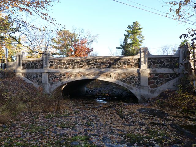
This bridge is the largest of several bridges and culverts in Keweenaw County that are noted for their stone facing that provides an aesthetic surface to a concrete structure. This technique of facing concrete with stone was more common in some other states. Early concrete bridge builders used stone as a way to make concrete look more attractive at a time when they had not yet learned to make concrete bridges look visually attractive using concrete alone. Another period of building concrete bridges with stone facing occurred with bridges built during the 1930s, often as part of federal Depression-era relief programs. However, these bridges in Keweenaw County fall into neither of these categories. Neither are they similar to bridge work done by either county road commissions or the Michigan State Highway Department at any point in history. It is unclear exactly what inspired these bridges although the fact that the highway has been a route for tourists and sight seers may have played a role. As the largest of these bridges the Fanny Hooe Creek is the most significant. It has been rehabilitated and retains excellent historic integrity. The stones on the bridge appear to all be locally sourced. Among the stones used, the geologically unusual red colored Copper Harbor conglomerate can be found.
This bridge is also unusual because it is a state trunkline bridge, but the Michigan State Highway Department hired the county road commission (rather than a private contractor, which would be typical) to build the bridge. Although not a state trunk line, another example of a bridge built by county road commission forces is in Macomb County. Even county-owned bridges were usually built by private contractors, rather than "in-house" by county forces.
Information and Findings From Michigan Historic Sites OnlineNarrative Description Located about a mile east of Copper Harbor, this small-scale arch bridge spans Fanny Hooe Creek on US-41. This crossing is situated immediately adjacent to Fort Wilkins State Park, almost at the end of the Keweenaw Peninsula. The structure is comprised of a 25 foot, filled spandrel concrete arch with an elliptically shaped continuous arch ring over a concrete foundation. The bridge's endwalls feature decoratively placed fieldstones, laid with grapevine mortar joints. Similar stonework is used for the parapet walls that flank the asphalt roadway. A series of four paneled concrete bulkheads and a concrete coping is built onto each parapet; these extend below the roadway level to form pilasters along the sidewalls. Built in 1927-1928, the Fanny Hooe Creek Bridge is unaltered and in excellent condition. Statement of Significance Soon after passage of the State Trunk Line Act in 1913, a north-south route across the western end of the Upper Peninsula began to coalesce. Designated across Keweenaw, Houghton, Ontonagon and Gogebic counties, it linked the major east-west trunk line across the Peninsula with the Peninsula's extreme northern tip at the Keweenaw Peninsula. Parts of this trunk line were incorporated into U.S. Highway 41 and 45. During the late 1910s and 1920s MSHD improved the road, regrading and rebuilding segments and building new bridges. One of these latter structures was constructed by the department over Fanny Hooe Creek near the road's northern terminus. MSHD engineer delineated the Fanny Hooe Creek Bridge in the summer of 1927, designated it Project No. MB-1 of 42-3-2. In August the department awarded a contract to build the bridge to the Keweenaw County Road Commission. The Fanny Hooe Creek Bridge was completed in the summer of 1928 at a cost of $8,132.02. "After one sees the masonry work on this bridge they will agree that the art work of the stone mason has not been entirely lost," stated MSHD engineer George Tramp. Since its completion, the bridge has functioned essentially unaltered condition. Although its 25 foot concrete arch is technologically unadventurous, the Fanny Hooe Creek Bridge is distinguished for its decorative stonework -- an aesthetic treatment not usually associated with Michigan highway bridges. The use of stonework is probably attributable both to the scenic nature of the highway through Keweenaw County as well as the craftsmanship of the county road commission. Michigan's northernmost bridge, the Fanny Hooe Bridge is historically significant as an integral, well-preserved part of this important Upper Peninsula artery. |
![]()
![]()
![]()
Coordinates (Latitude, Longitude):
Search For Additional Bridge Listings:
Bridgehunter.com: View listed bridges within 0.5 miles (0.8 kilometers) of this bridge.
Bridgehunter.com: View listed bridges within 10 miles (16 kilometers) of this bridge.
Additional Maps:
Google Streetview (If Available)
GeoHack (Additional Links and Coordinates)
Apple Maps (Via DuckDuckGo Search)
Apple Maps (Apple devices only)
Android: Open Location In Your Map or GPS App
Flickr Gallery (Find Nearby Photos)
Wikimedia Commons (Find Nearby Photos)
Directions Via Sygic For Android
Directions Via Sygic For iOS and Android Dolphin Browser
USGS National Map (United States Only)
Historical USGS Topo Maps (United States Only)
Historic Aerials (United States Only)
CalTopo Maps (United States Only)

© Copyright 2003-2024, HistoricBridges.org. All Rights Reserved. Disclaimer: HistoricBridges.org is a volunteer group of private citizens. HistoricBridges.org is NOT a government agency, does not represent or work with any governmental agencies, nor is it in any way associated with any government agency or any non-profit organization. While we strive for accuracy in our factual content, HistoricBridges.org offers no guarantee of accuracy. Information is provided "as is" without warranty of any kind, either expressed or implied. Information could include technical inaccuracies or errors of omission. Opinions and commentary are the opinions of the respective HistoricBridges.org member who made them and do not necessarily represent the views of anyone else, including any outside photographers whose images may appear on the page in which the commentary appears. HistoricBridges.org does not bear any responsibility for any consequences resulting from the use of this or any other HistoricBridges.org information. Owners and users of bridges have the responsibility of correctly following all applicable laws, rules, and regulations, regardless of any HistoricBridges.org information.
![]()