

View Information About HSR Ratings
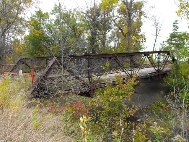
This bridge is on a section of roadway that has been abandoned and the bridge itself has also been long abandoned. The western abutment appears to be sinking, making the bridge deck have an incline that was not supposed to be there. This bridge is a traditional example of a riveted warren truss bridge with verticals but no outriggers. The truss bridge appears to retain excellent historic integrity with no major alterations noted. This bridge is also a rare example of a bridge with a jack-arch deck, an unusual deck type. It consists of using arched corrugated metal to make a span between the deck stringers, and then concrete is filled in on top of the arched corrugated metal. There are more surviving examples of this deck type in Michigan than in other states. Jack-arch decks did not stand the test of time, with the bridges than had them usually far outliving the decks themselves, so very few examples remain especially on bridges open to traffic, which will generally have had their deck replaced. Because Michigan has a lot of abandoned truss bridges, Michigan also has a lot of jack-arch decks because the deck was never replaced on an abandoned bridge. Like most remaining examples, the jack-arch deck is in very poor condition and has failed in several locations. The truss itself is in decent condition and could be restored.
![]()
![]()
![]()
Coordinates (Latitude, Longitude):
Search For Additional Bridge Listings:
Bridgehunter.com: View listed bridges within 0.5 miles (0.8 kilometers) of this bridge.
Bridgehunter.com: View listed bridges within 10 miles (16 kilometers) of this bridge.
Additional Maps:
Google Streetview (If Available)
GeoHack (Additional Links and Coordinates)
Apple Maps (Via DuckDuckGo Search)
Apple Maps (Apple devices only)
Android: Open Location In Your Map or GPS App
Flickr Gallery (Find Nearby Photos)
Wikimedia Commons (Find Nearby Photos)
Directions Via Sygic For Android
Directions Via Sygic For iOS and Android Dolphin Browser
USGS National Map (United States Only)
Historical USGS Topo Maps (United States Only)
Historic Aerials (United States Only)
CalTopo Maps (United States Only)

© Copyright 2003-2024, HistoricBridges.org. All Rights Reserved. Disclaimer: HistoricBridges.org is a volunteer group of private citizens. HistoricBridges.org is NOT a government agency, does not represent or work with any governmental agencies, nor is it in any way associated with any government agency or any non-profit organization. While we strive for accuracy in our factual content, HistoricBridges.org offers no guarantee of accuracy. Information is provided "as is" without warranty of any kind, either expressed or implied. Information could include technical inaccuracies or errors of omission. Opinions and commentary are the opinions of the respective HistoricBridges.org member who made them and do not necessarily represent the views of anyone else, including any outside photographers whose images may appear on the page in which the commentary appears. HistoricBridges.org does not bear any responsibility for any consequences resulting from the use of this or any other HistoricBridges.org information. Owners and users of bridges have the responsibility of correctly following all applicable laws, rules, and regulations, regardless of any HistoricBridges.org information.
![]()