

View Information About HSR Ratings
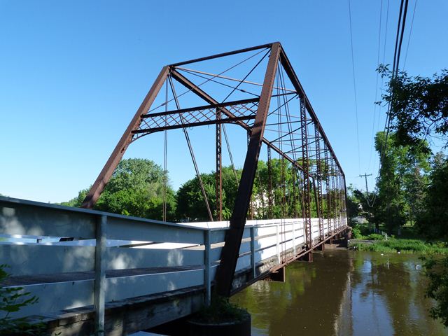
This bridge has an overall length listed of 231 feet, and a roughly estimated main span length of 190 feet. This main span is noteworthy as a long-span Pratt truss, particularly for 1885. In 1885, span lengths like this often used a Whipple truss configuration, but this bridge uses a basic Pratt. The bridge is also highly noteworthy as a bridge built by the Morse Bridge Company. Few examples of this company survive nationwide today, however, the company was noted for the variety of design and aesthetic details appearing among its surviving bridges. Where some bridge companies from the 19th Century repeatedly used the same standardized design, Morse Bridge Company seems to have changed its design either from year to year or bridge to bridge. This example is, by Morse Bridge Company, standards rather unornamented design, with its beauty coming from the geometry of its trusses alone. The bridge does have the distinctive cast iron washers on the connections that the Morse Bridge Company favored. The use of angle for lateral bracing as opposed to rod, was another typical detail on Morse Bridge Company bridges.
This bridge was closed to vehicular traffic in 1966. The bridge today is preserved for pedestrian use. The bridge retains excellent historic integrity. The loss of original railings and replacement with installation of somewhat visually obstructive wooden railings are the only major alteration noted. The bridge retains built-up floor beams and rests on riveted caissons, sometimes called Lally columns. The bridge is not painted, but is likely wrought iron which has impressive resistance to deterioration from rust. As such, the bridge appears to be structurally sound for its purpose today.
![]()
![]()
![]()
Coordinates (Latitude, Longitude):
Search For Additional Bridge Listings:
Bridgehunter.com: View listed bridges within 0.5 miles (0.8 kilometers) of this bridge.
Bridgehunter.com: View listed bridges within 10 miles (16 kilometers) of this bridge.
Additional Maps:
Google Streetview (If Available)
GeoHack (Additional Links and Coordinates)
Apple Maps (Via DuckDuckGo Search)
Apple Maps (Apple devices only)
Android: Open Location In Your Map or GPS App
Flickr Gallery (Find Nearby Photos)
Wikimedia Commons (Find Nearby Photos)
Directions Via Sygic For Android
Directions Via Sygic For iOS and Android Dolphin Browser
USGS National Map (United States Only)
Historical USGS Topo Maps (United States Only)
Historic Aerials (United States Only)
CalTopo Maps (United States Only)

© Copyright 2003-2024, HistoricBridges.org. All Rights Reserved. Disclaimer: HistoricBridges.org is a volunteer group of private citizens. HistoricBridges.org is NOT a government agency, does not represent or work with any governmental agencies, nor is it in any way associated with any government agency or any non-profit organization. While we strive for accuracy in our factual content, HistoricBridges.org offers no guarantee of accuracy. Information is provided "as is" without warranty of any kind, either expressed or implied. Information could include technical inaccuracies or errors of omission. Opinions and commentary are the opinions of the respective HistoricBridges.org member who made them and do not necessarily represent the views of anyone else, including any outside photographers whose images may appear on the page in which the commentary appears. HistoricBridges.org does not bear any responsibility for any consequences resulting from the use of this or any other HistoricBridges.org information. Owners and users of bridges have the responsibility of correctly following all applicable laws, rules, and regulations, regardless of any HistoricBridges.org information.
![]()