

View Information About HSR Ratings
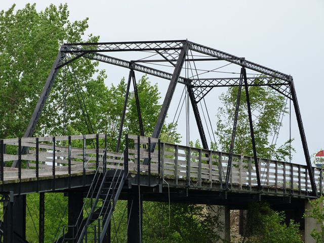
This bridge is an exceedingly rare example of a truss bridge that follows, in a general sense, the Thacher truss configuration. The Thacher truss configuration was invented and patented by Edwin Thacher, but companies reportedly managed to copy the truss design without infringing on the patent. Today, there are no extant true "Thacher patent truss bridges" as exactly specified in the patent, but there are a few adaptations that are classified by historians as Thacher truss bridges. This is one such example. It has a near-twin in Iowa, the Ellsworth Ranch Bridge. Be sure to view that page for a more detailed discussion. Because of the visual similarities to the Ellsworth Ranch Bridge, it is assumed that Milo A. Adams, an agent for King Bridge Company, would have helped the King Bridge Company design and construct this bridge just like he did with the Ellsworth Ranch Bridge. Milo A. Adams would later form his own self-named bridge company in Minneapolis. Little is known about Adams except that he was born in 1848 and died in 1922.
This bridge is highly significant as one of the few remaining Thacher truss bridges in the country, and is the only known example in Minnesota.
This bridge was originally located in Lac qui Parle County, Minnesota on TR-76 over the Yellow Bank River. It was relocated in 1989 to the Little Log House Pioneer Village. Here, the bridge is part of a historical village. Public access to the bridge is tricky, since this historical village only opens for tours once a year. The bridge can be viewed from a nearby public road however. The unusual spiral ramp that leads up to the bridge is not original or historic, but is a tribute to the long-lost Hastings Spiral Bridge which had a similar (albeit much larger) spiral ramp leading up to the main span.
![]()
![]()
![]()
Coordinates (Latitude, Longitude):
Search For Additional Bridge Listings:
Bridgehunter.com: View listed bridges within 0.5 miles (0.8 kilometers) of this bridge.
Bridgehunter.com: View listed bridges within 10 miles (16 kilometers) of this bridge.
Additional Maps:
Google Streetview (If Available)
GeoHack (Additional Links and Coordinates)
Apple Maps (Via DuckDuckGo Search)
Apple Maps (Apple devices only)
Android: Open Location In Your Map or GPS App
Flickr Gallery (Find Nearby Photos)
Wikimedia Commons (Find Nearby Photos)
Directions Via Sygic For Android
Directions Via Sygic For iOS and Android Dolphin Browser
USGS National Map (United States Only)
Historical USGS Topo Maps (United States Only)
Historic Aerials (United States Only)
CalTopo Maps (United States Only)

© Copyright 2003-2024, HistoricBridges.org. All Rights Reserved. Disclaimer: HistoricBridges.org is a volunteer group of private citizens. HistoricBridges.org is NOT a government agency, does not represent or work with any governmental agencies, nor is it in any way associated with any government agency or any non-profit organization. While we strive for accuracy in our factual content, HistoricBridges.org offers no guarantee of accuracy. Information is provided "as is" without warranty of any kind, either expressed or implied. Information could include technical inaccuracies or errors of omission. Opinions and commentary are the opinions of the respective HistoricBridges.org member who made them and do not necessarily represent the views of anyone else, including any outside photographers whose images may appear on the page in which the commentary appears. HistoricBridges.org does not bear any responsibility for any consequences resulting from the use of this or any other HistoricBridges.org information. Owners and users of bridges have the responsibility of correctly following all applicable laws, rules, and regulations, regardless of any HistoricBridges.org information.
![]()