

View Information About HSR Ratings
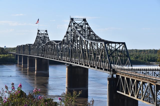
This is a large cantilever truss bridge. It is unusual among surviving American cantilever truss bridges for a visually obvious suspended span, since the suspended Pennsylvania truss span rises up and "breaks up" the flow of the top chord in the cantilever arms. The bridge was built under the authority of Vicksburg Bridge and Terminal Company and operated as a combination railroad and highway bridge, with both the highway deck and the railroad deck contained within the two truss lines. In 1947, the Warren County Board of Supervisors approved purchasing the bridge after the company went bankrupt. The construction of the I-20 Bridge lessened the importance of this bridge as a highway crossing. In 1998 it was closed to highway traffic after concrete failure on the western approach. The Mississippi Department of Transportation wanted to repair and reopen the bridge but Louisiana Department of Transportation and Development refused to allow this. Even though Louisiana Department of Transportation and Development does not maintain any part of the bridge, they own the road leading up to the western end of the bridge. Louisiana should be ashamed of itself for this, as a historic bridge the public should be allowed to use and appreciate the bridge. This is one of the finest historic bridges on the Mississippi River, and at the very least it should be open to pedestrian traffic. The bridge is currently fenced off with a massive steel wall and is inaccessible. For this reason, HistoricBridges.org has only a limited photodocumentation of this bridge.
One unique problem in this area for the two bridges over the river is a fault line. The bridge's most serious problem is the movement of pier 2, which is affected by the fault in the earth about 200-300 feet deep that also affects the Interstate 20 bridge. Pier 2 has moved between 30 and 32 inches from its original location in 1929, which is a very large amount for a bridge. This has resulted in the need for repairs and relocation of the bridge bearings.
More information is available on John Weeks website.
![]()
![]()
![]()
Coordinates (Latitude, Longitude):
Search For Additional Bridge Listings:
Bridgehunter.com: View listed bridges within 0.5 miles (0.8 kilometers) of this bridge.
Bridgehunter.com: View listed bridges within 10 miles (16 kilometers) of this bridge.
Additional Maps:
Google Streetview (If Available)
GeoHack (Additional Links and Coordinates)
Apple Maps (Via DuckDuckGo Search)
Apple Maps (Apple devices only)
Android: Open Location In Your Map or GPS App
Flickr Gallery (Find Nearby Photos)
Wikimedia Commons (Find Nearby Photos)
Directions Via Sygic For Android
Directions Via Sygic For iOS and Android Dolphin Browser
USGS National Map (United States Only)
Historical USGS Topo Maps (United States Only)
Historic Aerials (United States Only)
CalTopo Maps (United States Only)

© Copyright 2003-2024, HistoricBridges.org. All Rights Reserved. Disclaimer: HistoricBridges.org is a volunteer group of private citizens. HistoricBridges.org is NOT a government agency, does not represent or work with any governmental agencies, nor is it in any way associated with any government agency or any non-profit organization. While we strive for accuracy in our factual content, HistoricBridges.org offers no guarantee of accuracy. Information is provided "as is" without warranty of any kind, either expressed or implied. Information could include technical inaccuracies or errors of omission. Opinions and commentary are the opinions of the respective HistoricBridges.org member who made them and do not necessarily represent the views of anyone else, including any outside photographers whose images may appear on the page in which the commentary appears. HistoricBridges.org does not bear any responsibility for any consequences resulting from the use of this or any other HistoricBridges.org information. Owners and users of bridges have the responsibility of correctly following all applicable laws, rules, and regulations, regardless of any HistoricBridges.org information.
![]()