We Recommend:
Bach Steel - Experts at historic truss bridge restoration.
BridgeHunter.com Phase 1 is released to the public! - Visit Now
MacArthur Bridge
St. Louis Municipal Bridge

Primary Photographer(s): Nathan Holth
Bridge Documented: November 13, 2016
Railroad (Terminal Railroad Association of St. Louis) Over Mississippi River and Various Streets and Railroads
St. Louis and East St. Louis: St. Louis City, Missouri and St. Clair County, Illinois: United States
Metal 18 Panel Pin-Connected Pennsylvania Through Truss, Fixed and Approach Spans: Metal Deck Girder, Fixed
1917 By Builder/Contractor: American Bridge Company of New York, New York and Engineer/Design: Boller, Hodge, and Baird of New York, New York
Not Available or Not Applicable
668.0 Feet (203.6 Meters)
13,300.0 Feet (4053.8 Meters)
30 Feet (9.14 Meters)
3 Main Span(s)
Not Applicable

View Information About HSR Ratings
Bridge Documentation
This bridge has been altered, resulting in a severe loss of historic integrity and significance!
Bridge Status: Portions of this nationally significant historic bridge has been increasingly demolished in a piecework manner, first with removal of the second deck (prior to HistoricBridges.org documentation) and as of 2024, with the demolition of the Broadway Through Truss Spans, and the Western Highway Approach).View Missouri Historic Bridge Inventory Sheet For This Historic Bridge
View Historical News Article About Bridge
View Historical Book About Bridge
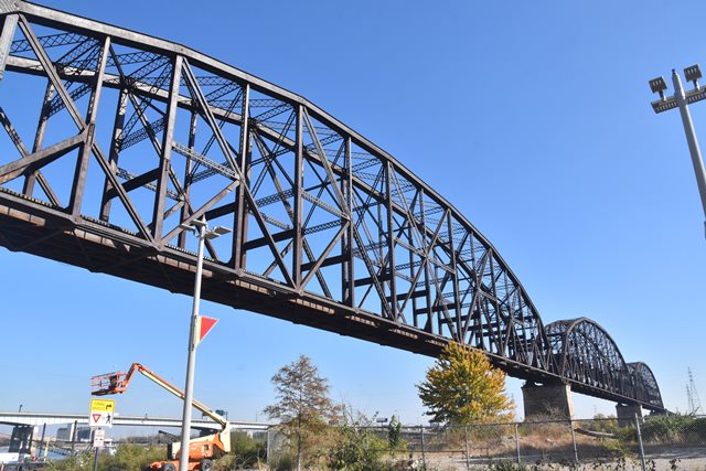
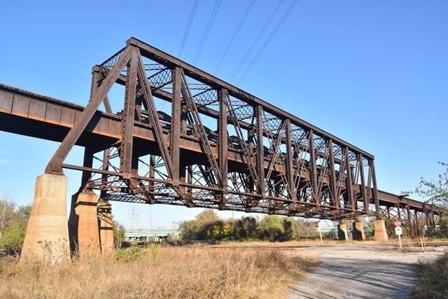
This bridge was originally built as a double-deck bridge with highway (on top) and railroad bridge (on bottom). Unfortunately, by the time this bridge was documented by HistoricBridges.org in 2016, a project to demolish nearly all of the long-abandoned highway deck was nearly completed, although some noteworthy highway portions remained on the approaches. Despite this loss, the remaining bridge is still one of the longest and most complex bridge systems in the country. HistoricBridges.org is proud to offer detailed coverage of not just the well-known Mississippi River spans, but also the lesser known but noteworthy approach sections.
The Mississippi River spans with their 668 foot spans (center to center of pins) or 772 feet (overall length) are among the longest simple truss spans in the entire country. This fact, combined with the unusually heavy double-deck design make this bridge a highly significant engineering feat.
One of the approach spans in particular is extremely unusual: the half-through truss span. The truss span is designed with three truss lines. The two northern truss lines supported the highway deck on top as a true deck truss. The southern two truss lines support the railroad line about halfway up the truss height, forming a rare half-through truss layout. To add to the unique design, the northern truss line is a Baltimore truss, while the other two truss lines are Pratt trusses.
Early investigations for locating this bridge were prepared in 1907 including input from two famous engineering firms, Ralph Modjeski and Waddell and Harrington.
Above: Historical construction photo showing main span construction.
Above: Historical construction photo showing 70 foot end post section shipped to site.
This bridge is tagged with the following special condition(s): Double-Deck
![]()
Photo Galleries and Videos: MacArthur Bridge
Main and Western Spans Bridge Photo-Documentation
Original / Full Size PhotosA collection of overview and detail photos. Photos of the main spans over the Mississippi River and the St. Louis western approach spans are included here. This gallery offers photos in the highest available resolution and file size in a touch-friendly popup viewer.
Alternatively, Browse Without Using Viewer
![]()
Main and Western Spans Photo-Documentation
Mobile Optimized PhotosA collection of overview and detail photos. Photos of the main spans over the Mississippi River and the St. Louis western approach spans are included here. This gallery features data-friendly, fast-loading photos in a touch-friendly popup viewer.
Alternatively, Browse Without Using Viewer
![]()
Eastern Spans Photo-Documentation
Original / Full Size PhotosA collection of overview and detail photos. This photo gallery is grouped into documentation of the various portions of the sprawling railroad and highway approach spans in East St. Louis. This gallery offers photos in the highest available resolution and file size in a touch-friendly popup viewer.
Alternatively, Browse Without Using Viewer
![]()
Eastern Spans Photo-Documentation
Mobile Optimized PhotosA collection of overview and detail photos. This photo gallery is grouped into documentation of the various portions of the sprawling railroad and highway approach spans in East St. Louis. This gallery features data-friendly, fast-loading photos in a touch-friendly popup viewer.
Alternatively, Browse Without Using Viewer
![]()
Maps and Links: MacArthur Bridge
Additional Coordinates: Mississippi River Spans: 38.61477, -90.18391 Half-Through Truss Span: 38.61212, -90.17379 Railroad Pennsylvania Truss Span: 38.60988, -90.16562 Highway Pennsylvania Truss Span: 38.61347, -90.16617 Broadway Trusses: 38.61767, -90.19324
Coordinates (Latitude, Longitude):
Search For Additional Bridge Listings:
Bridgehunter.com: View listed bridges within 0.5 miles (0.8 kilometers) of this bridge.
Bridgehunter.com: View listed bridges within 10 miles (16 kilometers) of this bridge.
Additional Maps:
Google Streetview (If Available)
GeoHack (Additional Links and Coordinates)
Apple Maps (Via DuckDuckGo Search)
Apple Maps (Apple devices only)
Android: Open Location In Your Map or GPS App
Flickr Gallery (Find Nearby Photos)
Wikimedia Commons (Find Nearby Photos)
Directions Via Sygic For Android
Directions Via Sygic For iOS and Android Dolphin Browser
USGS National Map (United States Only)
Historical USGS Topo Maps (United States Only)
Historic Aerials (United States Only)
CalTopo Maps (United States Only)


