We Recommend:
Bach Steel - Experts at historic truss bridge restoration.
BridgeHunter.com Phase 1 is released to the public! - Visit Now
MetroLink Footbridge

Primary Photographer(s): Nathan Holth and Rick McOmber
Bridge Documented: July 3, 2021 and April 1, 2022
St. Louis: St. Louis City, Missouri: United States
Not Available or Not Applicable
60.0 Feet (18.3 Meters)
105.0 Feet (32 Meters)
Not Available
3 Main Span(s)
Not Applicable

View Information About HSR Ratings
Bridge Documentation
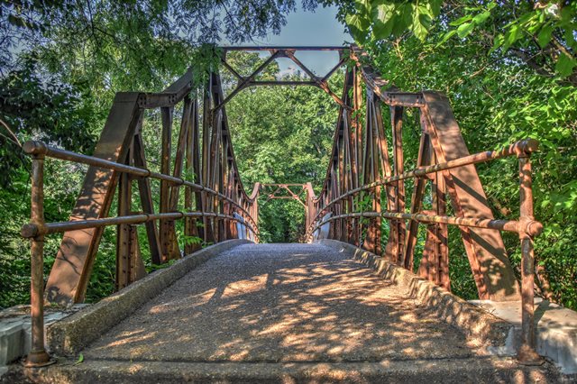
This is an extremely rare presentation of a tower style continuous through truss as a pedestrian footbridge. Lengths given are extremely rough estimates. The bridge has been poorly maintained despite its historic significance: The bridge requires painting, and someone thought (wrongly) that it would be a good idea to encase the bottoms of the endposts in concrete, a horrible alteration that fails to repair underlying end post deterioration, while only further trapping moisture and leading to deterioration. This bridge should immediately be fully restorerd for continued pedestrian use.
Despite the bridge's unusual design, very little information was available about it. Some research into local newspapers indicated that this area of railroad tracks was depressed through the park as part of a large project that included new bridges/viaducts at Lindell-Union Blvds and at Grand Drive, both of which are near this bridge. Reference was also made to a "separate foot bridge for pedestrians in the park" as being included in a contract let to R. J. Blackburn Inc. in July of 1930. Another article which was worded oddly and appeared to be confusing a concrete highway bridge to carry Grand Drive over the tracks and a pedestrian bridge stated the bridge (presumably the foot bridge) was 100 feet long. This is close to the estimated length of the bridge. A September 1932 article indicated that the project had been completed last summer. Therefore, the best available information found by HistoricBridges.org appears to suggest the bridge was built ca. 1931 by R. J. Blackburn Inc. as part of a grade crossing elimination project that involved depressing the tracks of the Wabash and Rock Island tracks in Forest Park.
View Historical Articles About This Bridge
This bridge is tagged with the following special condition(s): Unorganized Photos
![]()
Photo Galleries and Videos: MetroLink Footbridge
Bridge Photo-Documentation
Original / Full Size PhotosA collection of overview and detail photos. This gallery offers photos in the highest available resolution and file size in a touch-friendly popup viewer.
Alternatively, Browse Without Using Viewer
![]()
Bridge Photo-Documentation
Mobile Optimized PhotosA collection of overview and detail photos. This gallery features data-friendly, fast-loading photos in a touch-friendly popup viewer.
Alternatively, Browse Without Using Viewer
![]()
Additional Unorganized Photos
Original / Full Size PhotosA supplemental collection of photos that are from additional visit(s) to the bridge and have not been organized or captioned. This gallery offers photos in the highest available resolution and file size in a touch-friendly popup viewer.
Alternatively, Browse Without Using Viewer
![]()
Additional Unorganized Photos
Mobile Optimized PhotosA supplemental collection of photos that are from additional visit(s) to the bridge and have not been organized or captioned. This gallery features data-friendly, fast-loading photos in a touch-friendly popup viewer.
Alternatively, Browse Without Using Viewer
![]()
Maps and Links: MetroLink Footbridge
Coordinates (Latitude, Longitude):
Search For Additional Bridge Listings:
Bridgehunter.com: View listed bridges within 0.5 miles (0.8 kilometers) of this bridge.
Bridgehunter.com: View listed bridges within 10 miles (16 kilometers) of this bridge.
Additional Maps:
Google Streetview (If Available)
GeoHack (Additional Links and Coordinates)
Apple Maps (Via DuckDuckGo Search)
Apple Maps (Apple devices only)
Android: Open Location In Your Map or GPS App
Flickr Gallery (Find Nearby Photos)
Wikimedia Commons (Find Nearby Photos)
Directions Via Sygic For Android
Directions Via Sygic For iOS and Android Dolphin Browser
USGS National Map (United States Only)
Historical USGS Topo Maps (United States Only)
Historic Aerials (United States Only)
CalTopo Maps (United States Only)


