

View Information About HSR Ratings
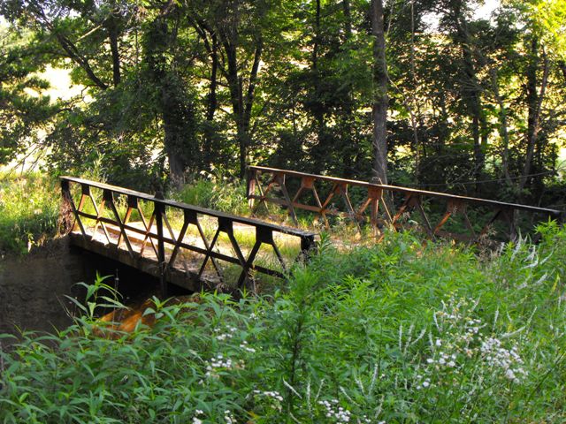
This bridge follows a rare design that was used from roughly 1900 through 1915. It consists of a double-Warren truss configuration made with built-up rolled beams made of up extremely lightweight riveted angles, and vertical endposts made of channels. It is a very distinctive and unique design that is immediately recognizable as dissimilar from all other truss types. Compare this bridge to Michigan's Powers Highway Bridge. Sometimes these small trusses are called lattice trusses because the truss looks like a lattice, especially on a small truss like these bridges, however this naming is not recomended because it leads to confusion with the Warren Quadrangular (and similar) truss configurations which is the real lattice truss configuration. The bridge type was marketed as an inexpensive and simpler alternative to the larger and more traditional truss bridge types that are familiar to this period. This bridge features gusset plates at the central top chord connection that rise up above the top chord and have two empty holes on them. These probably were a built-in feature to attach the bridge to a crane and lift it into place. Given the lightweight nature of the bridge, it is likely the trusses, if not the whole bridge, were brought to site pre-assembled.
This bridge is not a bedstead. Vertical endposts do not mean that a truss is a bedstead. Bedstead truss bridges combine superstructure and substructure, since they have a vertical end post that extends below the bottom chord to act as a bridge support (substructure).
The road this bridge is on as well as the bridge itself is open to motorized vehicular traffic, with the bridge having a six ton weight limit posted. However, the road is as unimproved and overgrown as some roads in states like Michigan that are completely abandoned! The "road" is a two-track roadway with extensive grass growing on the road, which constantly brushes the underside of any cars that drive on it.
![]()
![]()
![]()
Coordinates (Latitude, Longitude):
Search For Additional Bridge Listings:
Bridgehunter.com: View listed bridges within 0.5 miles (0.8 kilometers) of this bridge.
Bridgehunter.com: View listed bridges within 10 miles (16 kilometers) of this bridge.
Additional Maps:
Google Streetview (If Available)
GeoHack (Additional Links and Coordinates)
Apple Maps (Via DuckDuckGo Search)
Apple Maps (Apple devices only)
Android: Open Location In Your Map or GPS App
Flickr Gallery (Find Nearby Photos)
Wikimedia Commons (Find Nearby Photos)
Directions Via Sygic For Android
Directions Via Sygic For iOS and Android Dolphin Browser
USGS National Map (United States Only)
Historical USGS Topo Maps (United States Only)
Historic Aerials (United States Only)
CalTopo Maps (United States Only)

© Copyright 2003-2026, HistoricBridges.org. All Rights Reserved. Disclaimer: HistoricBridges.org is a volunteer group of private citizens. HistoricBridges.org is NOT a government agency, does not represent or work with any governmental agencies, nor is it in any way associated with any government agency or any non-profit organization. While we strive for accuracy in our factual content, HistoricBridges.org offers no guarantee of accuracy. Information is provided "as is" without warranty of any kind, either expressed or implied. Information could include technical inaccuracies or errors of omission. Opinions and commentary are the opinions of the respective HistoricBridges.org member who made them and do not necessarily represent the views of anyone else, including any outside photographers whose images may appear on the page in which the commentary appears. HistoricBridges.org does not bear any responsibility for any consequences resulting from the use of this or any other HistoricBridges.org information. Owners and users of bridges have the responsibility of correctly following all applicable laws, rules, and regulations, regardless of any HistoricBridges.org information.
![]()