We Recommend:
Bach Steel - Experts at historic truss bridge restoration.
Chain of Rocks Bridge

Primary Photographer(s): Nathan Holth
Bridge Documented: November 3, 2013
Pedestrian Walkway (Trailnet) (Historic US-66) Over Mississippi River
Granite City and St. Louis: Madison County, Illinois and St. Louis City, Missouri: United States
Metal Continuous 20 Panel Rivet-Connected Modified Warren (Subdivided) Through Truss, Fixed and Approach Spans: Metal 8 Panel Rivet-Connected Warren Through Truss, Fixed
1929 By Builder/Contractor: American Bridge Company of New York, New York and Engineer/Design: Baxter L. Brown and Edward B. Fay of St. Louis, Missouri
1999
700.0 Feet (213.4 Meters)
5,353.0 Feet (1631.6 Meters)
24 Feet (7.32 Meters)
10 Main Span(s) and 6 Approach Span(s)
Not Applicable

View Information About HSR Ratings
Bridge Documentation
View The National Register of Historic Places Nomination Form For This Historic Bridge
View Historical Article About This and Other Mississippi River Bridges
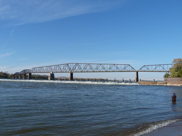
This monumental bridge is an unusual design. The main spans consist of a series of five two-span continuous trusses, making a total of ten spans. The centermost continuous pair of spans is much larger than the other spans and consists of two 700 foot spans for a total of 1400 feet of continuous truss. This design of multiple sets of continuous trusses is very unusual and gives this bridge a distinctive appearance, quite dissimilar from other more common continuous truss bridges where there might only be two continuous spans total in the whole bridge. The appearance is even more dissimilar from cantilever truss bridges, which was another bridge type common to the period when this bridge was built.
The other most visually distinctive feature of this bridge is that it has a 30 degree bend immediately west of the largest two continuous spans. Curved bridges are rare, but even more rare is this design where instead of a curve, there is a single bend in the bridge that changes the direction of the roadway. This bend caused the bridge to be a bottleneck for traffic. This bend was not part of the original design plans, but was added late in the design process. There were a few reasons this bend was put into the bridge design. First, visitors to the bridge will note the two beautiful water pumping towers immediately south of the bridge. The bend aligned the piers of the bridge with the location of these pumping towers, alleviating concerns of boaters that navigating through a maze of both pumping towers and piers in a variety of locations would be too challenging. Also, the bend allowed for the piers of the bridge to be built on more stable bedrock.
The bridge was substructure and superstructure was erected by the Union Bridge and Construction Company of New York. The American Bridge Company of New York manufactured the trusses.
The bridge was completed in 1929 and operated as a toll bridge as part of the famous US-66 until the new Chain of Rocks Bridge was built north of this bridge. Soon after the new bridge was built, this historic bridge was closed to traffic since there was not enough traffic to justify the cost of maintaining it for cars. After this time, the bridge faced some threats of demolition, but they never panned out. In 1999, an organization called Trailnet made the bridge part of their trail system and converted it for pedestrian use. Today, the bridge is one of the largest historic bridges preserved for pedestrian use. Despite their beauty and historic significance, large river bridges that are bypassed by new bridges are rarely left standing for pedestrian use. They are usually demolished. This has led to a devastating and needless loss of America's big river bridges. The Chain of Rocks Bridge is a notable exception and is an outstanding example of how big river bridges can be reused by pedestrians when they are replaced by new vehicular bridges. The bridge appears to be quite popular as numerous people were using the bridge during the field visit in November.
It is widely reported that visitors should always park at the lot on the Illinois side of the river to visit this bridge. The parking lot on the Missouri side has had an extremely large number of cars broken into by thieves and vandals. In contrast, the Illinois side is secured by cameras and is more safe. The bridge itself also is safe, and as stated is fairly well used.
Information and Findings From Missouri's Historic Bridge InventoryBridge Features superstructure: steel, 20- and 12-panel, rigid-connected cantilevered through truss, with rigid-connected Warren through truss approach spans Discussion of Bridge Route 66 between Chicago and Los Angeles was formally designated a United States Highway in November 1926 by the Secretary of Agriculture, as part of the country's newly designated interstate highway system. The largest city between the highway's two termini, St. Louis also presented the widest river crossing along its length-over the Mississippi River. As originally routed, the highway crossed into St. Louis over the McKinley Bridge [STLC16]; around 1934 it was later switched over the MacArthur Bridge [STLCIS]. Both of these spans funneled traffic into St. Louis's warehouse district, however, further congesting the already-congested city streets downtown. In the late 1930s the route was again shifted, this time over the Chain of Rocks Bridge, which, at 40 feet, had a deck ten feet wider than MacArthur. Chain of Rocks brought travelers into the city from the north, past the popular Chain of Rocks amusement park, called "one of the prettiest places in the city." This latter span carried Route 66 traffic until its closure in 1970. The Chain of Rocks Bridge had been built in the late 1920s to provide highway access between Madison, Illinois, and north St. Louis. Reportedly the sixth vehicular bridge over the Mississippi River in the area, it was sponsored by private money and paid for by tolls. In 1927 the Chain-of-Rocks and Kingshighway Bridge Company, a consortium of local capitalists led by Tom and John Scott, received a Congressional charter to build a highway bridge over the Mississippi River near the city's Chain of Rocks water pumping station. Designed by St. Louis consulting engineer Baxter L. Brown, the structure would cost $1.25 million. As delineated by Brown, the Chain of Rocks Bridge consisted of five continuous, rigid-connected trusses that formed ten spans, the longest of which extended 700 feet. These were supported on massive concrete piers some 55 feet above the high water mark and were approached on both sides by a series of simply supported trusses and, on the north side, a four-mile-long fill. The bridge was to be located immediately upstream from the intake tower for the water works. Originally planned with a straight roadway over its one-mile length, its configuration was changed under orders of the War Department after riverboatmen complained of the difficulty in steering around both the bridge and the tower. The re-designed bridge incorporated a 30 degree bend in its roadway near mid-span. Despite the assurance that the tum would be "protected by special signs and signals, so that traffic will not be appreciably slowed down," the bent bridge formed a bottleneck that became legendary. The contract to build the concrete substructure and erect the steel superstructure was awarded to the Union Bridge and Construction Company of New York; the American Bridge Company was hired to fabricate the trusses. Actual construction began in 1927; by March 1928 the steelworkers were ready to begin erection of the superstructure on the partially complete substructure. When the piers were completed in August 1928, the engineers predicted a January 1st opening. Subsequent high waters on the Mississippi delayed this for another half-year, however. Eventually costing about $2.S million to construct, the Chain of Rocks Bridge was opened ceremoniously to traffic on July 20, 1929. Three years later the City of Madison issued $2.3 million in bonds and purchased the structure from the bridge company. The city continued collecting tolls until August 1957, at which time the bridge was opened for free passage. In 1970 it was closed to traffic altogether. Since that time, the bridge has been a target of graffiti by gangs, the prop for the movie "Escape from New York," and in 1991 the scene of a grisly double murder. Its future is presently clouded. As the "Main Street of America" that extended from Chicago to Los Angeles, Route 66 has proved vital in the development of American commerce and culture. "For forty-nine years that highway was a factor in millions of trips, vacations, and relocations," wrote historian Susan Croce. "It provided a living to countless men and women, ran down main streets of the hometowns of millions more, and figured in a billion personal experiences. It brought wealth and recognition to people like Bobby Troup and John Steinbeck. It brought destruction and death to others who did not respect its twists and turns and peculiarities." Forming the highway's crossing over America's largest river, the Mississippi, the Chain of Rocks Bridge has played a pivotal role in the highway's history. The bridge is technologically important as an outstanding example of large-scale highway bridge construction in the 1920s. With its graceful, long-span trusses cantilevered over tapered concrete piers and the awkward bend in the roadway, the structure is both noteworthy and distinctive. It is today a well-preserved, nationally important remnant of early highway design and construction-one of Missouri's most important bridges. Bridge Considered Historic By Survey: Yes |
![]()
Photo Galleries and Videos: Chain of Rocks Bridge
Structure Overview
Original / Full Size PhotosA collection of overview photos that show the bridge as a whole and general areas of the bridge. This gallery offers photos in the highest available resolution and file size in a touch-friendly popup viewer.
Alternatively, Browse Without Using Viewer
![]()
Structure Details
Original / Full Size PhotosA collection of detail photos that document the parts, construction, and condition of the bridge. This gallery offers photos in the highest available resolution and file size in a touch-friendly popup viewer.
Alternatively, Browse Without Using Viewer
![]()
Structure Overview
Mobile Optimized PhotosA collection of overview photos that show the bridge as a whole and general areas of the bridge. This gallery features data-friendly, fast-loading photos in a touch-friendly popup viewer.
Alternatively, Browse Without Using Viewer
![]()
Structure Details
Mobile Optimized PhotosA collection of detail photos that document the parts, construction, and condition of the bridge. This gallery features data-friendly, fast-loading photos in a touch-friendly popup viewer.
Alternatively, Browse Without Using Viewer
![]()
Maps and Links: Chain of Rocks Bridge
Coordinates (Latitude, Longitude):
Search For Additional Bridge Listings:
Bridgehunter.com: View listed bridges within 0.5 miles (0.8 kilometers) of this bridge.
Bridgehunter.com: View listed bridges within 10 miles (16 kilometers) of this bridge.
Additional Maps:
Google Streetview (If Available)
GeoHack (Additional Links and Coordinates)
Apple Maps (Via DuckDuckGo Search)
Apple Maps (Apple devices only)
Android: Open Location In Your Map or GPS App
Flickr Gallery (Find Nearby Photos)
Wikimedia Commons (Find Nearby Photos)
Directions Via Sygic For Android
Directions Via Sygic For iOS and Android Dolphin Browser
USGS National Map (United States Only)
Historical USGS Topo Maps (United States Only)
Historic Aerials (United States Only)
CalTopo Maps (United States Only)


