

View Information About HSR Ratings

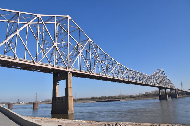
Although this is a relatively late example of a riveted cantilever through truss, it remains highly significant due to the increasing rarity of this bridge type in the United States thanks to demolition. Further, the bridge is technologically significant for the length of the main cantilever span.
Planning for the bridge was directed by the engineering firm of George A. Maney and Associates. George A. Maney died during the early engineering stages of the project. Maney, according to local news articles, was also working with Charles A. Ellis on this project, but he died in 1949, so apparently his involvement with this bridge was only in the design stage. Ellis is of note in engineering history as he was responsible for the majority of the engineering design of the Golden Gate Bridge. After these deaths, engineering was taken over by another noted engineering firm, Hazelet and Erdal.
Many contractors were involved with the actual bridge construction. The general contractor for the bridge was J. Howard, Inc. of Chicago, Illinois. Massman Construction Company of Kansas City, Missouri (successor to the noted Kansas City Bridge Company of Kansas City, Missouri) was the substructure contractor. A number of contractors and subcontractors were involved with the superstructure fabrication and erection. These included the Robinson Erection Company of St. Louis, Missouri, Midland Steel and Allied Fabricators, Stupp Brothers of St. Louis, Missouri, and the Bethlehem Steel Company of Bethlehem, Pennsylvania, and John F. Beasley Company of Muskogee, Oklahoma.
The configuration of the bridge is as follows:
Missouri Approach
- Span W: 45'-0" simple beam span
- Spans X, Y, 1 and
2: 238'-0" continuous four-span beam span
- Span 3: 53'-0" simple beam span
- Spans 4 and 6: 240'-0" continuous two-span girder/stringer/cross-beam span (no
existing span is identified as Span 5)
- Spans 7 - 8: 94'-0" continuous
two-span beam span Main Spans
- Spans 9 - 11: 1902'-10" three-span
cantilevered through truss
Illinois Approach
- Spans 12 and 13: 213'-1"
simple deck truss spans
- Spans 14 - 17, 19 - 22, 24 - 27 and 29 - 32:
216'-3" continuous four-span beam spans
- Spans 18, 23 and 28: 45'-9" simple
beam spans
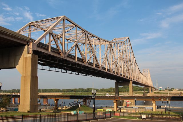
Structurally a separate bridge (dimensions omitted from technical facts table above), but otherwise part of the same bridge system is the Illinois Approach Bridge, immediately east of this bridge. The main span of this bridge is a rivet-connected polygonal Warren through truss.
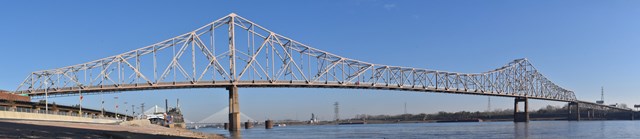
Above: Panoramic view of cantilever truss spans.
Above: The Illinois Approach Bridge.
This bridge is tagged with the following special condition(s): Unorganized Photos
![]()
![]()
![]()
![]()
![]()
Coordinates (Latitude, Longitude):
Search For Additional Bridge Listings:
Bridgehunter.com: View listed bridges within 0.5 miles (0.8 kilometers) of this bridge.
Bridgehunter.com: View listed bridges within 10 miles (16 kilometers) of this bridge.
Additional Maps:
Google Streetview (If Available)
GeoHack (Additional Links and Coordinates)
Apple Maps (Via DuckDuckGo Search)
Apple Maps (Apple devices only)
Android: Open Location In Your Map or GPS App
Flickr Gallery (Find Nearby Photos)
Wikimedia Commons (Find Nearby Photos)
Directions Via Sygic For Android
Directions Via Sygic For iOS and Android Dolphin Browser
USGS National Map (United States Only)
Historical USGS Topo Maps (United States Only)
Historic Aerials (United States Only)
CalTopo Maps (United States Only)

© Copyright 2003-2024, HistoricBridges.org. All Rights Reserved. Disclaimer: HistoricBridges.org is a volunteer group of private citizens. HistoricBridges.org is NOT a government agency, does not represent or work with any governmental agencies, nor is it in any way associated with any government agency or any non-profit organization. While we strive for accuracy in our factual content, HistoricBridges.org offers no guarantee of accuracy. Information is provided "as is" without warranty of any kind, either expressed or implied. Information could include technical inaccuracies or errors of omission. Opinions and commentary are the opinions of the respective HistoricBridges.org member who made them and do not necessarily represent the views of anyone else, including any outside photographers whose images may appear on the page in which the commentary appears. HistoricBridges.org does not bear any responsibility for any consequences resulting from the use of this or any other HistoricBridges.org information. Owners and users of bridges have the responsibility of correctly following all applicable laws, rules, and regulations, regardless of any HistoricBridges.org information.
![]()