We Recommend:
Bach Steel - Experts at historic truss bridge restoration.
BridgeHunter.com Phase 1 is released to the public! - Visit Now
MO-OO Bridge
Old US-40 Bridge

Primary Photographer(s): Nathan Holth and Rick McOmber
Bridge Documented: July 3, 2009
Rural: Cooper County, Missouri: United States
Not Available or Not Applicable
60.0 Feet (18.3 Meters)
60.0 Feet (18.3 Meters)
20 Feet (6.1 Meters)
1 Main Span(s)
4609

View Information About HSR Ratings
Bridge Documentation
This bridge no longer exists!
View Archived National Bridge Inventory Report - Has Additional Details and Evaluation
This historic bridge was damaged by a truck in April 2012, then demolished and replaced by MoDOT around September 2012!
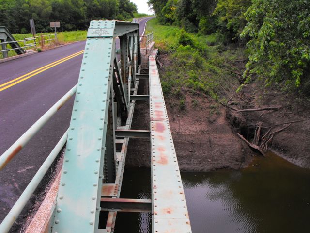
This bridge is a traditionally composed pony truss that retains good historic integrity. It is on old US-40 alignment but today instead carries a secondary state-owned route. The bridge has an unusual feature which is a single riveted built-up box beam that runs parallel right next to but slightly higher than the bottom chord. This beam is just outside the truss line, and it bends at the ends to fit and attach against the angle of the abutment wingwalls. It is attached to the truss itself by means of small rolled i-beams. The detail can be seen in the photo on this page. It is unclear what purpose this beam serves, whether it is meant to carry cables or if it might be meant as a shield against flood damage, or some other purpose.
This bridge was destroyed by a truck pulling a bulldozer in April 2012. It was demolished and replaced as a result sometime around September 2012. Damage of this type to historic bridges can be prevented through money-saving rehabilitation programs. As part of rehabilitation, crash-resistant guiderail can be installed on bridges like this one, thereby \protecting the trusses from vehicular impact . Typically, this guiderail can be installed, while leaving the original railing in place behind, so as not to alter the bridge and disturb its historic integrity. MoDOT failed to protect this bridge through such a rehabilitation project.
![]()
Photo Galleries and Videos: MO-OO Bridge
Bridge Photo-Documentation
Original / Full Size PhotosA collection of overview and detail photos. This gallery offers photos in the highest available resolution and file size in a touch-friendly popup viewer.
Alternatively, Browse Without Using Viewer
![]()
Bridge Photo-Documentation
Mobile Optimized PhotosA collection of overview and detail photos. This gallery features data-friendly, fast-loading photos in a touch-friendly popup viewer.
Alternatively, Browse Without Using Viewer
![]()
Maps and Links: MO-OO Bridge
This historic bridge has been demolished. This map is shown for reference purposes only.
Coordinates (Latitude, Longitude):
Search For Additional Bridge Listings:
Bridgehunter.com: View listed bridges within 0.5 miles (0.8 kilometers) of this bridge.
Bridgehunter.com: View listed bridges within 10 miles (16 kilometers) of this bridge.
Additional Maps:
Google Streetview (If Available)
GeoHack (Additional Links and Coordinates)
Apple Maps (Via DuckDuckGo Search)
Apple Maps (Apple devices only)
Android: Open Location In Your Map or GPS App
Flickr Gallery (Find Nearby Photos)
Wikimedia Commons (Find Nearby Photos)
Directions Via Sygic For Android
Directions Via Sygic For iOS and Android Dolphin Browser
USGS National Map (United States Only)
Historical USGS Topo Maps (United States Only)
Historic Aerials (United States Only)
CalTopo Maps (United States Only)

