

View Information About HSR Ratings

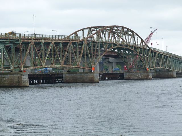
This bridge is the only surviving example of a unique design of bridge designed by Fay, Spofford, and Thorndike. The larger and earlier example was the Lake Champlain Bridge, now demolished. The three central spans of the bridge are one of the earliest examples in the country of a design of bridge that was copied by a number of engineers in future bridge projects. The design features a deck truss that transitions into a through truss, using an arched shape. The specific design as seen here and later adapted by others does not include hangers, and can either be constructed to function, like the General Sullivan Bridge, in a hingeless format (continuous truss) or a hinged design (cantilever truss). These bridges are sometimes called "arched continuous trusses" or "arched cantilever trusses." However the theory and general design behind these varieties of bridges can be further adapted to allow the center portion of the truss to arch well above the roadway, and to connect to the roadway via hangers. This variation is called a "suspended-deck continuous truss" or "suspended-deck cantilever truss." Fay, Spofford, and Thorndike also built some of the earliest examples of suspended-deck truss bridges as well.
Given that this bridge is among the earliest surviving examples of its style, as well as an early surviving highway continuous truss, it is hard to understate the historic significance of this bridge. It is certainly among the most significant bridges in New Hampshire.
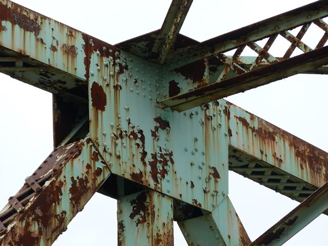
The General Sullivan Bridge has been bypassed by a modern bridge, however was left standing next to its replacement. There was serious concerns that despite this, the bridge was still at risk for demolition. However, a visit to the bridge in 2012 found that a large approach structure had been built to reach the northern end of the bridge, which was disconnected as part of the continuing project to provide a wider vehicular bridge next to the historic bridge. This substantial approach structure accommodates non-motorized traffic. It seems unlikely that the bridge currently faces demolition, if such expense went toward producing this new approach system. There is some cause for continuing concern however, since one of the southern approach spans is signed and partially fenced to limit the number of pedestrians on it, suggesting there is some form of deterioration on this particular span. It is hoped that the bridge will receive whatever repairs are needed to ensure this exceedingly significant historic bridge remains for decades to come.
![]()
![]()
![]()
![]()
![]()
Access this bridge from the north on Dover Point Road, where there is a small park from where you can both view and walk on the bridge and park your car.
Coordinates (Latitude, Longitude):
Search For Additional Bridge Listings:
Bridgehunter.com: View listed bridges within 0.5 miles (0.8 kilometers) of this bridge.
Bridgehunter.com: View listed bridges within 10 miles (16 kilometers) of this bridge.
Additional Maps:
Google Streetview (If Available)
GeoHack (Additional Links and Coordinates)
Apple Maps (Via DuckDuckGo Search)
Apple Maps (Apple devices only)
Android: Open Location In Your Map or GPS App
Flickr Gallery (Find Nearby Photos)
Wikimedia Commons (Find Nearby Photos)
Directions Via Sygic For Android
Directions Via Sygic For iOS and Android Dolphin Browser
USGS National Map (United States Only)
Historical USGS Topo Maps (United States Only)
Historic Aerials (United States Only)
CalTopo Maps (United States Only)

© Copyright 2003-2024, HistoricBridges.org. All Rights Reserved. Disclaimer: HistoricBridges.org is a volunteer group of private citizens. HistoricBridges.org is NOT a government agency, does not represent or work with any governmental agencies, nor is it in any way associated with any government agency or any non-profit organization. While we strive for accuracy in our factual content, HistoricBridges.org offers no guarantee of accuracy. Information is provided "as is" without warranty of any kind, either expressed or implied. Information could include technical inaccuracies or errors of omission. Opinions and commentary are the opinions of the respective HistoricBridges.org member who made them and do not necessarily represent the views of anyone else, including any outside photographers whose images may appear on the page in which the commentary appears. HistoricBridges.org does not bear any responsibility for any consequences resulting from the use of this or any other HistoricBridges.org information. Owners and users of bridges have the responsibility of correctly following all applicable laws, rules, and regulations, regardless of any HistoricBridges.org information.
![]()