

View Information About HSR Ratings
This bridge is overall a traditional Pratt truss, yet is also noted for a couple unusual details. The portal bracing is lightweight, and the same design as the struts, being composed of a small strip of plate riveted to angle. Some of the rivets on the bridge are not the typical round head, and are instead steeple head or cone head type. A few other bridges in western New Jersey have these details, and may all be the work of the same builder.
There is another interesting rivet-related observation to be made on this bridge. Looking at the rivets which connect plate to the rolled i-beams on the vertical members, you may note than some of those rivets have deformed heads. The location of these rivets on beam flanges would have made them difficult to drive, accounting for the deformed appearance. The interior rivet heads could not be held in place or driven head-on because of the other beam flange being in the way.
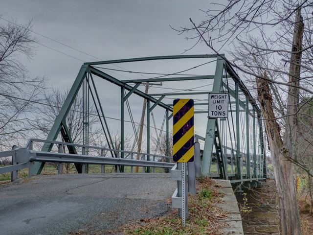
Information and Findings From New Jersey's Historic Bridge InventoryDiscussion of Bridge The 6-panel Pratt thru truss bridge is pin connected. The connections were reinforced with welded plates in 1976. It is supported on random ashlar abutments and wingwalls. Other alterations include reinforcements on floorbeams, top struts and knee braces, added diagonal end posts, metal pan deck and guiderail. One of ten Pratt thru-truss bridges in the county, the many alterations have compromised the design integrity and historical significance of the bridge. Discussion of Surrounding Area The single span single lane thru truss bridge carries Cider Mill Road (Reaville-Clover Hill, CR 29) over the Neshanic River. It is located in a pastoral setting of open fields, farm buildings, corn fields and scattered trees. It carries a lightly traveled country road. Bridge Considered Historic By Survey: No |
![]()
![]()
![]()
Coordinates (Latitude, Longitude):
Search For Additional Bridge Listings:
Bridgehunter.com: View listed bridges within 0.5 miles (0.8 kilometers) of this bridge.
Bridgehunter.com: View listed bridges within 10 miles (16 kilometers) of this bridge.
Additional Maps:
Google Streetview (If Available)
GeoHack (Additional Links and Coordinates)
Apple Maps (Via DuckDuckGo Search)
Apple Maps (Apple devices only)
Android: Open Location In Your Map or GPS App
Flickr Gallery (Find Nearby Photos)
Wikimedia Commons (Find Nearby Photos)
Directions Via Sygic For Android
Directions Via Sygic For iOS and Android Dolphin Browser
USGS National Map (United States Only)
Historical USGS Topo Maps (United States Only)
Historic Aerials (United States Only)
CalTopo Maps (United States Only)

© Copyright 2003-2026, HistoricBridges.org. All Rights Reserved. Disclaimer: HistoricBridges.org is a volunteer group of private citizens. HistoricBridges.org is NOT a government agency, does not represent or work with any governmental agencies, nor is it in any way associated with any government agency or any non-profit organization. While we strive for accuracy in our factual content, HistoricBridges.org offers no guarantee of accuracy. Information is provided "as is" without warranty of any kind, either expressed or implied. Information could include technical inaccuracies or errors of omission. Opinions and commentary are the opinions of the respective HistoricBridges.org member who made them and do not necessarily represent the views of anyone else, including any outside photographers whose images may appear on the page in which the commentary appears. HistoricBridges.org does not bear any responsibility for any consequences resulting from the use of this or any other HistoricBridges.org information. Owners and users of bridges have the responsibility of correctly following all applicable laws, rules, and regulations, regardless of any HistoricBridges.org information.
![]()