

View Information About HSR Ratings
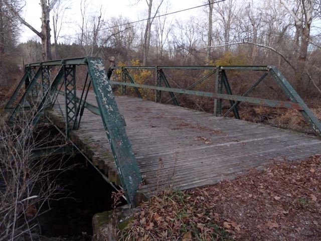
This bridge sits on what was once a through road, but today is more of a trail. The bridge itself has bollards and as such is intended today to be used only by non-motorized traffic. The bridge might have been built by the Wrought Iron Bridge Company because the vertical members use rolled "T" and lattice which that company preferred, but this is not certain. The Historic Bridge Inventory listed the verticals as back to back angles, but this is incorrect; they are rolled "T" sections.
Note: the photos of this bridge were taken in low-light conditions, so the quality is not great.
Information and Findings From New Jersey's Historic Bridge InventorySummary The pin-connected Pratt pony truss bridge supported on concrete abutments has a laminated timber deck. Alterations are limited to the addition of welded outriggers and steel railings were welded to the truss. The span is distinguished because it is a very well-preserved example of an important early metal truss bridge type. Located within undeveloped parkland, the integrity of the original setting has not been compromised. Date of construction and builder are undocumented. Setting/Context The bridge carries a 1-lane, 2-way street over a shallow stream in a wooded undeveloped area located within the Flat Brook-Roy Wildlife Management Area. Physical Description The single-span pin-connected half-hip Pratt pony truss bridge supported on concrete abutments, spans 46' and carries an 11'6" wide road. The four-panel truss is composed of standard-design members. Upper chords are back-to-back channels with cover plate on the top and lattice on the bottom of the built-up box member. Bottom chords are pairs of rectangular section eye bar at center bays and circular section bars at end bays. Verticals are back-to-back angles joined by lattice. Diagonal members are pairs of square section bars, and counters are single circular section rods. Outriggers were welded to the truss at each panel point at unknown dates, and a steel channel guide rail has been was welded to each inside truss face. The span has a laminated timber deck. Historical and Technological Significance The ca. 1890 Pratt pony truss bridge is a very well-preserved example of an increasingly uncommon bridge type (Criterion C). The span, although undocumented to date of construction and builder, is a virtually unaltered example of the most common late-19th century bridge type. It is one of four eligible pony truss spans in Sussex County (1900D07, Smith Mill Road, Frankford Twp.; 1900E10, Scott Road, Franklin Borough; 1900W06, Main Street, Walpack Township). The bridge is located within the undeveloped Flat Brook-Roy Wildlife Management Area, and the integrity of setting has not been compromised. Through the third quarter of the 19th century, a variety of truss designs were developed and patented, but the one that proved to be the most economical, efficient, and easy to fabricate and erect in the field was the Pratt truss, which has the verticals in compression and the diagonals in tension. The truss was patented by Thomas and Caleb Pratt in 1844, and the earliest examples were a combination of wood (for the compression members) and iron (for tensile members). The Pratt truss went on through the century to become the most common design, and it was not until technological advances made it possible to execute reliable field riveted connections after about 1890 that the Warren truss superseded the pin-connected Pratts on the nations highways and byways. Boundary Description and Justification The bridge is rated individually eligible. The boundary is limited to the superstructure and substructure of the bridge itself. Sources Sussex County Engineer's Office. Bridge Files. Bridge Considered Historic By Survey: Yes |
![]()
![]()
![]()
Coordinates (Latitude, Longitude):
Search For Additional Bridge Listings:
Bridgehunter.com: View listed bridges within 0.5 miles (0.8 kilometers) of this bridge.
Bridgehunter.com: View listed bridges within 10 miles (16 kilometers) of this bridge.
Additional Maps:
Google Streetview (If Available)
GeoHack (Additional Links and Coordinates)
Apple Maps (Via DuckDuckGo Search)
Apple Maps (Apple devices only)
Android: Open Location In Your Map or GPS App
Flickr Gallery (Find Nearby Photos)
Wikimedia Commons (Find Nearby Photos)
Directions Via Sygic For Android
Directions Via Sygic For iOS and Android Dolphin Browser
USGS National Map (United States Only)
Historical USGS Topo Maps (United States Only)
Historic Aerials (United States Only)
CalTopo Maps (United States Only)

© Copyright 2003-2024, HistoricBridges.org. All Rights Reserved. Disclaimer: HistoricBridges.org is a volunteer group of private citizens. HistoricBridges.org is NOT a government agency, does not represent or work with any governmental agencies, nor is it in any way associated with any government agency or any non-profit organization. While we strive for accuracy in our factual content, HistoricBridges.org offers no guarantee of accuracy. Information is provided "as is" without warranty of any kind, either expressed or implied. Information could include technical inaccuracies or errors of omission. Opinions and commentary are the opinions of the respective HistoricBridges.org member who made them and do not necessarily represent the views of anyone else, including any outside photographers whose images may appear on the page in which the commentary appears. HistoricBridges.org does not bear any responsibility for any consequences resulting from the use of this or any other HistoricBridges.org information. Owners and users of bridges have the responsibility of correctly following all applicable laws, rules, and regulations, regardless of any HistoricBridges.org information.
![]()