

View Information About HSR Ratings
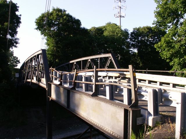
This bridge is unusual because the top and bottom chords are both equally curved and thus remain parallel. The curving was done to increase clearance for trains without increasing substructure and approach work/costs.
The bridge has been well maintained. Rather than demolish this historic bridge, Hunterdon County has signalized the one-lane bridge to ensure that this one-lane bridge with notable issues with seeing opposing traffic on the other side of the bridge remains safe for the traveling public. This solution represents an effective way to ensure that historic bridges do not compete with the requirement and expectation that public roadways be safe, reliable, and functional.
Information and Findings From New Jersey's Historic Bridge InventoryDiscussion of Bridge The 3-span bridge is composed of two short deck girder approach spans and a 6-panel riveted Warren with verticals pony truss main span built with curved parallel chords to increase clearance over the tracks. It is supported on concrete abutments and laced steel bents. Riveted outriggers are original. An expansion plate is located in the center of the span. Although there are no distinctive details, it is an unaltered example of a bridge type commonly used by the railroads since the 1890s. The structure is individually eligible for listing in the National Register under Criterion C. Discussion of Surrounding Area The bridge carries one lane of a lightly traveled 2-lane street over a single line of track of the Lehigh Valley Railroad now used as a Conrail freight line. It is located in a wooded village setting. Modern development is encroaching. Bridge Considered Historic By Survey: Yes |
![]()
![]()
![]()
Coordinates (Latitude, Longitude):
Search For Additional Bridge Listings:
Bridgehunter.com: View listed bridges within 0.5 miles (0.8 kilometers) of this bridge.
Bridgehunter.com: View listed bridges within 10 miles (16 kilometers) of this bridge.
Additional Maps:
Google Streetview (If Available)
GeoHack (Additional Links and Coordinates)
Apple Maps (Via DuckDuckGo Search)
Apple Maps (Apple devices only)
Android: Open Location In Your Map or GPS App
Flickr Gallery (Find Nearby Photos)
Wikimedia Commons (Find Nearby Photos)
Directions Via Sygic For Android
Directions Via Sygic For iOS and Android Dolphin Browser
USGS National Map (United States Only)
Historical USGS Topo Maps (United States Only)
Historic Aerials (United States Only)
CalTopo Maps (United States Only)

© Copyright 2003-2024, HistoricBridges.org. All Rights Reserved. Disclaimer: HistoricBridges.org is a volunteer group of private citizens. HistoricBridges.org is NOT a government agency, does not represent or work with any governmental agencies, nor is it in any way associated with any government agency or any non-profit organization. While we strive for accuracy in our factual content, HistoricBridges.org offers no guarantee of accuracy. Information is provided "as is" without warranty of any kind, either expressed or implied. Information could include technical inaccuracies or errors of omission. Opinions and commentary are the opinions of the respective HistoricBridges.org member who made them and do not necessarily represent the views of anyone else, including any outside photographers whose images may appear on the page in which the commentary appears. HistoricBridges.org does not bear any responsibility for any consequences resulting from the use of this or any other HistoricBridges.org information. Owners and users of bridges have the responsibility of correctly following all applicable laws, rules, and regulations, regardless of any HistoricBridges.org information.
![]()