

View Information About HSR Ratings
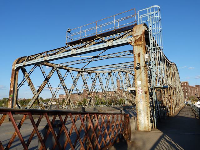
This bridge is one of two similar swing bridges in Newark. The other is on Jackson Street. They are similar both because they have a rare lattice truss configuration and also because their top chord has a genuine curve to it, as opposed to a polygonal design which is how a curve-like shape is normally achieved with a truss. These two unusual details were shared with two swing bridges (now demolished) over the Harlem River in nearby New York City, including the Willis Avenue Bridge. Aside from these four bridges, this design, which could be described as a European form, is essentially nonexistent in the United States. With the Harlem River Bridges gone, the two in Newark are thus exceedingly rare. Of the two in Newark, Clay Street is a little more interesting because it has the further detail where the top chord curves directly into the vertical end post. The Jackson Street Bridge does not have this detail. These days, Clay Street is also more significant since it lacks the alteration found with the Jackson Street Bridge.
Lacking the alteration found on Jackson Street means that this bridge retains its original struts and lateral bracing. The struts are built-up beams that include v-lacing. The portal bracing has been altered by making it shorter to increase vertical clearance on the bridge. The trusses appear to be largely unaltered and thus retain good historic integrity. Floorbeams are original built-up beams.
It is greatly hoped that the Clay Street Bridge, which is in need of at least a repainting and perhaps a full rehabilitation, will be rehabilitated in a manner that is respective to maintaining the original materials and designs of the historic bridge. It would be a shame to see alterations similar to those found on Jackson Street to occur here. If original materials are replaced on this bridge that should be replaced in-kind with replicas, not modern knockoffs. Only this way can the aesthetic and historic attributes of this bridge be kept as great as they are today.
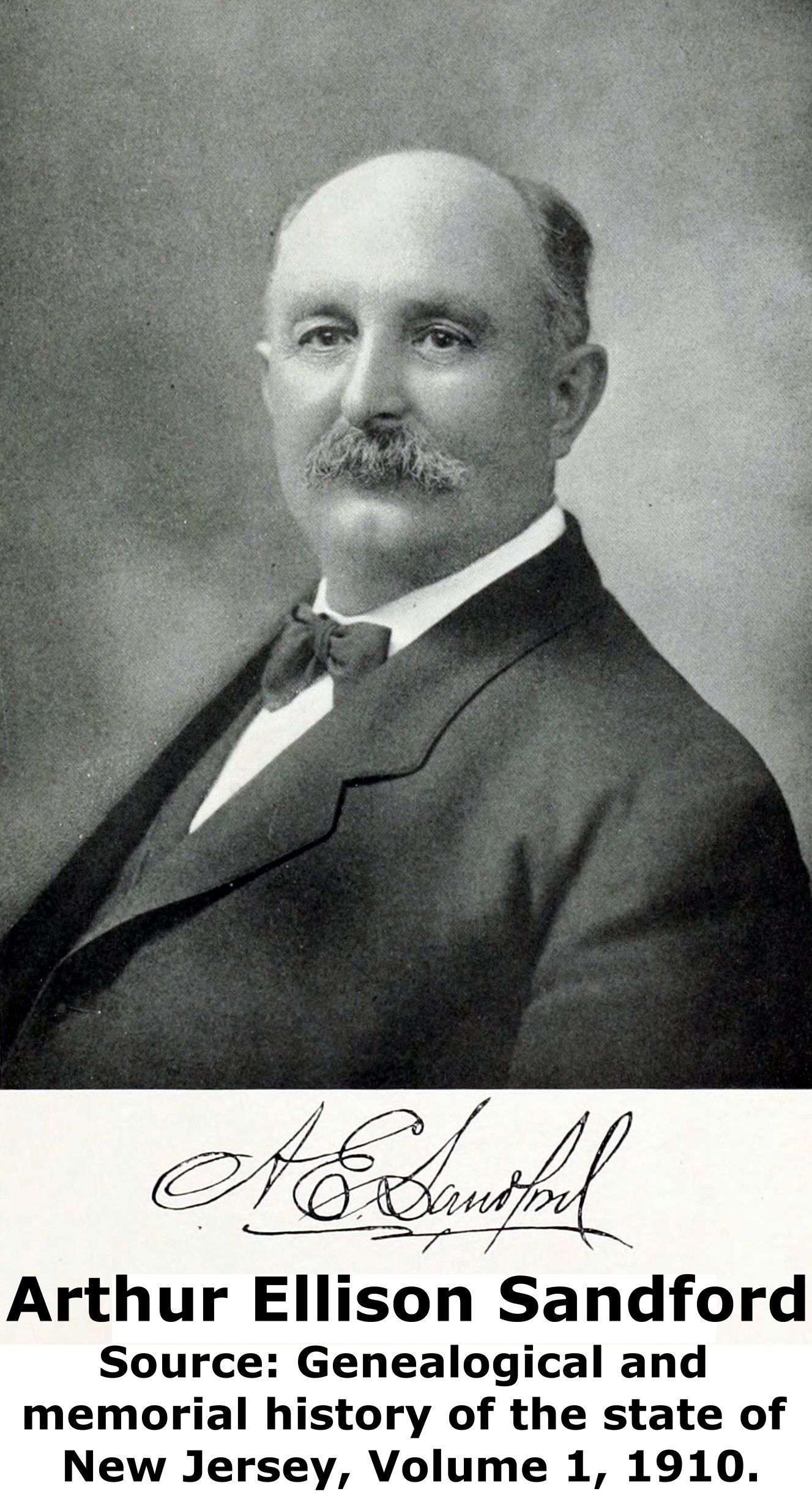
The contractor for this bridge was the A. E. Sandford Company, which was run by Arthur Ellison Sandford.

Information and Findings From New Jersey's Historic Bridge InventorySummary The triple-intersection Warren thru truss swing-span bridge with 1975 replacement approach spans is supported on concrete abutments and an ashlar center pier. It was significantly altered in 1975 when the operating mechanisms (gears, motors, controls., overhead generator house) were replaced with modern equipment. The span is historically important, and the unusual trusses are fairly complete. The bridge still operates in the original manner and is thus noteworthy. Bibliography: Physical Description The 3-span bridge is composed of a riveted triple-intersection Warren through truss rim-bearing swing-span, and two approach spans. The bridge measures 326' in length and carries a 38' roadway and 2 cantilevered sidewalks. The trusses have an unusual profile because of the parabolic-shape of the top chords and the curved connection between the top chords and the end posts. The latter is an aesthetic consideration, not a structural one. The top chords are built-up members composed back-to-back channels connected by lattice at the bottom and a cover plate at the top. The diagonal and vertical members are built-up with two pairs of back-to-back angles separated by lacing or batten plates. The lower chords are back-to-back channels connected by lattice. The trusses themselves have some strengthening, but they are for the most part well preserved. The cantilevered sidewalks are enclosed by the original wrought-iron lattice-pattern railings. In 1975, the bridge was rehabilitated. The east approach span was replaced with pre-stressed voided slab beams, stringers were replaced and the girders and floor beams were repaired at the west approach span. The floor beam stiffener angles and stringers were replaced at the swing-span, the bridge deck was replaced, new concrete pedestals were placed at the west quarter pier, a new concrete header was added at the east quarter pier, and the timber fender system was repaired. The truss diagonal members were strengthened by adding plates and angles to form a box section. The gate house at the east approach and the overhead generator room located at the center of the span date to the 1975 rehabilitation. In 1992 the timber fenders were repaired and several sidewalk brackets were replaced. The operating mechanisms were also replaced in the 1975 rehabilitation, but the span still operates in the original manner, by means of a rack and pinion drive mechanism, now powered by new electric motors (the bridge was originally powered by a steam engine) activated by modern control panels . The pinions and gears (one open set, one enclosed reducer) are now at the side of the drum girder, which rides on in-kind replacement wheels, rather than in the original position at the center. There are also new screw jack end lifts rather than wedges. The drum girder, drum girders, radial, and floor beams are original, although they too have been strengthened. Technological and Historical Significance The 1908 Clay Street rim-bearing swing-span bridge, located in the industrial heart of Newark, was designed by J. Owen, the Essex County engineer and constructed by A. E. Sandford Co., a local contractor. The span replaced an 1889 wrought iron draw span built to help alleviate heavy traffic on the Bridge Street Bridge (0700H03) located downstream. The swing span was one of at least two in Newark that were powered for many years by a steam engine (Jackson Street (0700H02) is the other. Its steam engine is now in the collection of the Newark Museum). The bridge is a large example of its type, and the truss type of the main span, a triple-intersection Warren thru truss, is not common. While the bridge has been so altered, the trusses and how the span operates remains fairly original. Because of its size, operable condition, truss type, and historic associations with the development of Newark, one of the premier industrial centers in the region, the span is historically and technologically distinguished (Criteria A,C). It is one of three similar rim-bearing swing span bridges in the center of Newark, and the other two (0700H02, 0700H03) have also been evaluated as significant. Boundary Description & Justification The movable span of the bridge is evaluated as significant. The approach spans have been either replaced or severely altered so that they no longer have historical or technological significance. The boundary is thus limited to the movable span and the center pier upon which it bears when in the open position. Discussion of Surrounding Area The bridge carries a 2-lane road and sidewalks over a major river in the heart of industrial Newark. The surrounding structures are industrial and commercial and date from the 1900s through the 1970s. Bridge Considered Historic By Survey: Yes |
![]()
![]()
![]()
Coordinates (Latitude, Longitude):
Search For Additional Bridge Listings:
Bridgehunter.com: View listed bridges within 0.5 miles (0.8 kilometers) of this bridge.
Bridgehunter.com: View listed bridges within 10 miles (16 kilometers) of this bridge.
Additional Maps:
Google Streetview (If Available)
GeoHack (Additional Links and Coordinates)
Apple Maps (Via DuckDuckGo Search)
Apple Maps (Apple devices only)
Android: Open Location In Your Map or GPS App
Flickr Gallery (Find Nearby Photos)
Wikimedia Commons (Find Nearby Photos)
Directions Via Sygic For Android
Directions Via Sygic For iOS and Android Dolphin Browser
USGS National Map (United States Only)
Historical USGS Topo Maps (United States Only)
Historic Aerials (United States Only)
CalTopo Maps (United States Only)

© Copyright 2003-2024, HistoricBridges.org. All Rights Reserved. Disclaimer: HistoricBridges.org is a volunteer group of private citizens. HistoricBridges.org is NOT a government agency, does not represent or work with any governmental agencies, nor is it in any way associated with any government agency or any non-profit organization. While we strive for accuracy in our factual content, HistoricBridges.org offers no guarantee of accuracy. Information is provided "as is" without warranty of any kind, either expressed or implied. Information could include technical inaccuracies or errors of omission. Opinions and commentary are the opinions of the respective HistoricBridges.org member who made them and do not necessarily represent the views of anyone else, including any outside photographers whose images may appear on the page in which the commentary appears. HistoricBridges.org does not bear any responsibility for any consequences resulting from the use of this or any other HistoricBridges.org information. Owners and users of bridges have the responsibility of correctly following all applicable laws, rules, and regulations, regardless of any HistoricBridges.org information.
![]()