We Recommend:
Bach Steel - Experts at historic truss bridge restoration.
Harvey Road Bridge

Primary Photographer(s): Elaine Deutsch
Bridge Documented: August 18, 2013
Rural: Monmouth County, New Jersey: United States
By Builder/Contractor: Unknown
1950
Not Available
40.0 Feet (12.2 Meters)
15 Feet (4.57 Meters)
1 Main Span(s)
1300U23

View Information About HSR Ratings
Bridge Documentation
View Archived National Bridge Inventory Report - Has Additional Details and Evaluation
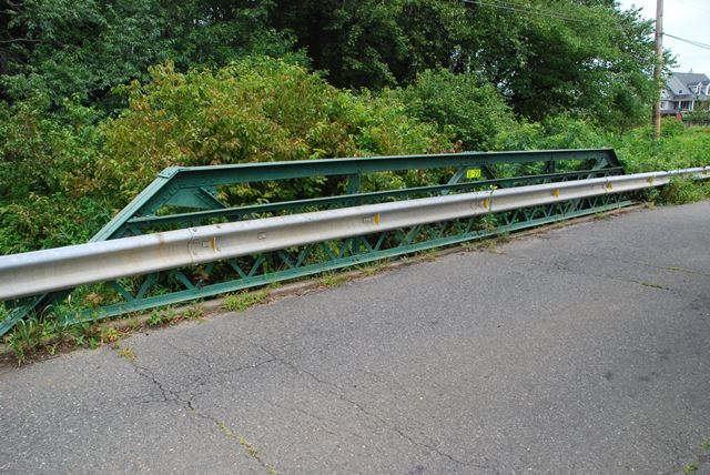
This is a small pony truss bridge that likely dates to the early 20th century. Bridges like this where paired angles were the main type of built-up beam on the truss were usually built between 1900 and 1915. Like a number of truss bridges in this area, this bridge has had bents added that support the load of traffic these days, rendering the trusses non-functional.
Information and Findings From New Jersey's Historic Bridge InventoryDiscussion of Bridge The ca. 1915 rivet-connected Warren pony truss bridge with verticals, lattice railings, outriggers, and concrete abutments has been subjected to limited modifications. Like other truss bridges in Monmouth County, the floorbeams were all underpinned ca. 1945. There appear to have been no modifications to the trusses. Although timber stringers, not the trusses, support the live load, the loss of function of the trusses has minimal impact on the integrity of the structure. The 1915 date of construction is based on stylistic analysis of the bridge; no early records were located at the County Engineer's office. The bridge is one of four remaining in the County of this once common type. It is individually eligible for listing in the National Register of Historic Places under Criterion C as a representative example of a riveted Warren pony truss. Physical Description: The bridge is a 3-panel rivet-connected Warren with verticals pony truss. It measures 40'-long and 15'-wide, and it is composed of standard rolled steel members. The upper chords, lower chords, diagonals, and verticals are all composed of riveted back-toback steel angles. The flooring system consists of I-beam floor beams and new timber stringers with wood plank deck with asphalt wearing surface. The floor beams have been underpinned with timber piles, so the span now functions with live loads as a stringer rather than a truss span. The abutments are concrete. The bridge has lattice railings and rivet-connected outriggers that appear to be original. Historical and Technological Significance: The Harvey Road Warren truss bridge is one of four similar examples of the type in the county (130MT21, Locust Avenue over Claypit Creek, c.1910, Middletown Twp.; 1300A23, Creamery Road over Yellow Brook, c.1910, Colts Neck Twp.; 1300U26, Smith Mill Road over Lahaway Creek, c.1915, Upper Freehold Twp.), but modifications to the way in which live loads are supported have significantly altered its technological and historical value. A review of the old plans and photographs located in the county engineer's office revealed that Warren pony truss bridges were common in Monmouth County. However, this example has no significant construction details, is only 40' long, and does not have integrity of original design. Additionally, it is undocumented. No records of the builder, date of construction, or plans survive with the county engineer. A 1949 inspection report indicates that the truss had been underpinned by that date. The county engineer underpinned most of the truss bridges in the 1940s and 1950s, and all of the known surviving highway truss bridges in the county have been underpinned. The Harvey Road bridge stylistically dates from ca. 1915, and is a representative but undistinguished example of pony truss bridge technology. Its rural setting is appropriate to its original historic context. Discussion of Surrounding Area The two-lane bridge spans a small creek in picturesque rural surroundings. Next to the bridge are wooded lots and horse pasture. Within view are two 19th-century farmhouses with outbuildings. Bridge Considered Historic By Survey: No |
![]()
Photo Galleries and Videos: Harvey Road Bridge
Bridge Photo-Documentation
Original / Full Size PhotosA collection of overview and detail photos. This gallery offers photos in the highest available resolution and file size in a touch-friendly popup viewer.
Alternatively, Browse Without Using Viewer
![]()
Bridge Photo-Documentation
Mobile Optimized PhotosA collection of overview and detail photos. This gallery features data-friendly, fast-loading photos in a touch-friendly popup viewer.
Alternatively, Browse Without Using Viewer
![]()
Maps and Links: Harvey Road Bridge
Coordinates (Latitude, Longitude):
Search For Additional Bridge Listings:
Bridgehunter.com: View listed bridges within 0.5 miles (0.8 kilometers) of this bridge.
Bridgehunter.com: View listed bridges within 10 miles (16 kilometers) of this bridge.
Additional Maps:
Google Streetview (If Available)
GeoHack (Additional Links and Coordinates)
Apple Maps (Via DuckDuckGo Search)
Apple Maps (Apple devices only)
Android: Open Location In Your Map or GPS App
Flickr Gallery (Find Nearby Photos)
Wikimedia Commons (Find Nearby Photos)
Directions Via Sygic For Android
Directions Via Sygic For iOS and Android Dolphin Browser
USGS National Map (United States Only)
Historical USGS Topo Maps (United States Only)
Historic Aerials (United States Only)
CalTopo Maps (United States Only)

