

View Information About HSR Ratings
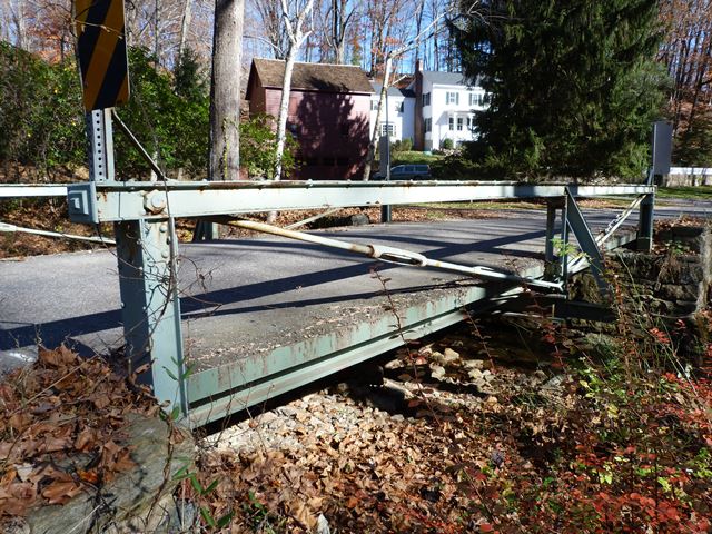
This tiny bridge is one of the most unusual truss bridges in the county, which is really saying something given how many truss bridges HistoricBridges.org documented in the county. The Historic Bridge Inventory tried to classify this bridge as a form of Fink or Bollman truss. This does not make sense, although they had the right idea in noting that it is a very rare type of bridge. It appears to function as an inverted Kingpost truss bridge. What makes this bridge an inverted Kingpost instead of a two panel Pratt truss? The lack of a bottom chord, and the vertical end posts from which the kingpost truss hangs are the key features. This bridge's top chord extends beyond the end posts which is an unusual detail. The top chord has decorative cast iron caps on the ends.
Information and Findings From New Jersey's Historic Bridge InventorySummary The skewed 2-panel pin-connected Fink-like truss bridge bears on random stone abutments with wingwalls. There are minor welded alterations and repairs, but the unusual trusses perform like a Bollman with a floor beam hung from the diagonals. Undocumented as to original date and fabricator, the bridge dates stylistically to ca. 1880 and is the sole known example of its type in the county. It is technologically significant based on the design of the trusses. Setting/Context The bridge carries one lane of a lightly travelled country road over a minor stream in a wooded rural setting adjacent to a well-maintained early-19th century farmstead. The setting is unspoiled and contributes to the significance of the bridge. Physical Description The 33'-long, one-span, pin-connected pony truss bridge is a variation of the Bollman truss in which the chief characteristic is that the floor beam(s) are supported by a pair of diagonals which span from end of span to end of span, accomplished in this 2-panel bridge by pairs of loop forged eye bars. Bars in one panel are fitted with a turnbuckle for adjustments. The top chord, end posts, and one vertical appear to be original, although repaired several times. The trusses consist of vertical end posts which are a pair of channels with a full-height cover plate on the approach roadway face and a top and bottom batten plate on the span face. The top chord is made up of a pair of channels with a top cover plate and bottom batten plates. It extended beyond the end post by about 8" and is finished with a decorative cast cover. The top chord is a compression strut that holds the supporting columns (end posts) from falling in to the middle. There are no bottom chord elements. The vertical is a pair of channels with top and bottom battens. The one on the upstream side is a modern replacement. The vertical is a "dummy" member which serves only to halve the unsupported length of the top chord. The rolled I-section floor beam is supported on an inverted U-hanger which passes over the pin connecting the diagonals. The end posts are set on plates on the ashlar abutments. The steel grid deck was placed in 1962. Historical and Technological Significance Although undocumented as to date of construction and fabricator, the span is a rare example of a Fink or Bollman truss type where the floor beams are supported by a pair of diagonals that span from end of span to end of span. Originally designed for the combination of wood and iron, the Bollman truss was developed in 1850, and while it increased the possible length of bridges of its day, it passed from favor by 1880 because it is not a rigid truss. Dated stylistically to ca. 1880, the bridge represents the most basic expression of the Fink or Bollman truss form (it is not developed enough to indicate which diagonal pattern it would have been had it been more than two panels long), and it is historically and technologically significant as a rare and fairly complete survivor of the pre-Civil War bridge technology. Sources Condit, Carl. American Building Art 19th Century. 1960. Bridge Considered Historic By Survey: Yes |
![]()
![]()
![]()
Coordinates (Latitude, Longitude):
Search For Additional Bridge Listings:
Bridgehunter.com: View listed bridges within 0.5 miles (0.8 kilometers) of this bridge.
Bridgehunter.com: View listed bridges within 10 miles (16 kilometers) of this bridge.
Additional Maps:
Google Streetview (If Available)
GeoHack (Additional Links and Coordinates)
Apple Maps (Via DuckDuckGo Search)
Apple Maps (Apple devices only)
Android: Open Location In Your Map or GPS App
Flickr Gallery (Find Nearby Photos)
Wikimedia Commons (Find Nearby Photos)
Directions Via Sygic For Android
Directions Via Sygic For iOS and Android Dolphin Browser
USGS National Map (United States Only)
Historical USGS Topo Maps (United States Only)
Historic Aerials (United States Only)
CalTopo Maps (United States Only)

© Copyright 2003-2024, HistoricBridges.org. All Rights Reserved. Disclaimer: HistoricBridges.org is a volunteer group of private citizens. HistoricBridges.org is NOT a government agency, does not represent or work with any governmental agencies, nor is it in any way associated with any government agency or any non-profit organization. While we strive for accuracy in our factual content, HistoricBridges.org offers no guarantee of accuracy. Information is provided "as is" without warranty of any kind, either expressed or implied. Information could include technical inaccuracies or errors of omission. Opinions and commentary are the opinions of the respective HistoricBridges.org member who made them and do not necessarily represent the views of anyone else, including any outside photographers whose images may appear on the page in which the commentary appears. HistoricBridges.org does not bear any responsibility for any consequences resulting from the use of this or any other HistoricBridges.org information. Owners and users of bridges have the responsibility of correctly following all applicable laws, rules, and regulations, regardless of any HistoricBridges.org information.
![]()