

View Information About HSR Ratings
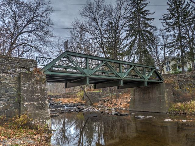
There apparently has been some debate on the construction date of this bridge. It may be that the truss (despite its narrow roadway) may have been the "rebuilt" (as an all-new structure) portion of the bridge referenced on a marble plaque at the bridge, and the stone abutments date to a previous bridge. The heavy trusses are suggestive of a 1920s bridge. The National Bridge Inventory lists an 1850 construction date, it is not known if that might be when the abutments were actually built.
Information and Findings From New Jersey's Historic Bridge InventoryDiscussion of Bridge The riveted 4-panel Warren with verticals pony truss bridge is supported on concrete abutments (from 1929) with stone wingwalls. Lattice web railings remain. Floor beam flanges are notched for connection to the verticals. The date of construction is not documented, but county engineer records state it was reconstructed in 1929. Stylistically it appears to be a 20th-century bridge. One of over 25 Warren pony trusses in the county, and it is not technologically nor historically noteworthy. Discussion of Surrounding Area The bridge carries one lane of a lightly traveled country road over a minor stream in a wooded rural setting with sparse housing. A dam is located 150' upstream. An altered 19th-century mill and house are next to the bridge. The altered mill is not an eligible resource. Bridge Considered Historic By Survey: No |
![]()
![]()
![]()
Coordinates (Latitude, Longitude):
Search For Additional Bridge Listings:
Bridgehunter.com: View listed bridges within 0.5 miles (0.8 kilometers) of this bridge.
Bridgehunter.com: View listed bridges within 10 miles (16 kilometers) of this bridge.
Additional Maps:
Google Streetview (If Available)
GeoHack (Additional Links and Coordinates)
Apple Maps (Via DuckDuckGo Search)
Apple Maps (Apple devices only)
Android: Open Location In Your Map or GPS App
Flickr Gallery (Find Nearby Photos)
Wikimedia Commons (Find Nearby Photos)
Directions Via Sygic For Android
Directions Via Sygic For iOS and Android Dolphin Browser
USGS National Map (United States Only)
Historical USGS Topo Maps (United States Only)
Historic Aerials (United States Only)
CalTopo Maps (United States Only)

© Copyright 2003-2024, HistoricBridges.org. All Rights Reserved. Disclaimer: HistoricBridges.org is a volunteer group of private citizens. HistoricBridges.org is NOT a government agency, does not represent or work with any governmental agencies, nor is it in any way associated with any government agency or any non-profit organization. While we strive for accuracy in our factual content, HistoricBridges.org offers no guarantee of accuracy. Information is provided "as is" without warranty of any kind, either expressed or implied. Information could include technical inaccuracies or errors of omission. Opinions and commentary are the opinions of the respective HistoricBridges.org member who made them and do not necessarily represent the views of anyone else, including any outside photographers whose images may appear on the page in which the commentary appears. HistoricBridges.org does not bear any responsibility for any consequences resulting from the use of this or any other HistoricBridges.org information. Owners and users of bridges have the responsibility of correctly following all applicable laws, rules, and regulations, regardless of any HistoricBridges.org information.
![]()