

View Information About HSR Ratings
This bridge is a traditional example of highway plate girder. It retains fabricator plaques showing the notable Phoenix Bridge Company. Additionally, there are plaques for each county (this is a county line bridge) which someone thought would make a great place to bolt modern guardrail to, blocking the view of the plaques and also ruining them because there are multiple holes drilled in them to mount the guardrail. Original sidewalk railings remain as well.
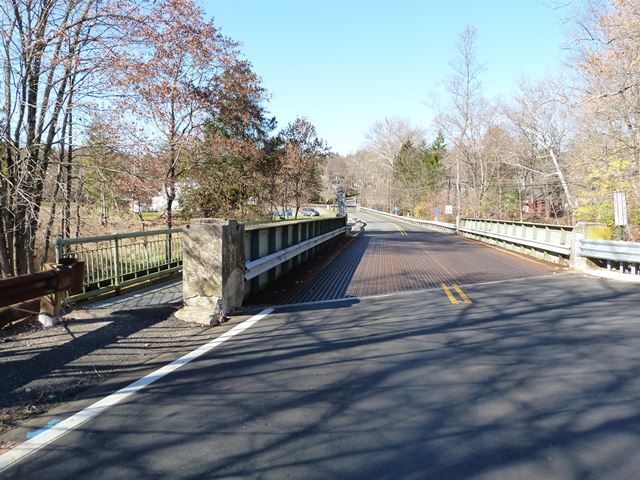
Information and Findings From New Jersey's Historic Bridge InventoryDiscussion of Bridge The skewed thru girder with floor beams bridge is of built up construction. The original encasement has been partially removed, and a new steel grid deck on rolled risers has been installed. The original metal railing at the cantilevered sidewalk remains. Beam guide rail has been added at the inside face of the girders. A representative example of a common bridge type, the span is not technologically or historically noteworthy. Discussion of Surrounding Area The bridge carries a 2-lane county road over the Lamington River. It is located in a wooded village setting at the intersection of two moderately traveled roads. It is adjacent to a small retail establishment and parking area. The setting is undistinguished. Bridge Considered Historic By Survey: No |
![]()
![]()
![]()
Coordinates (Latitude, Longitude):
Search For Additional Bridge Listings:
Bridgehunter.com: View listed bridges within 0.5 miles (0.8 kilometers) of this bridge.
Bridgehunter.com: View listed bridges within 10 miles (16 kilometers) of this bridge.
Additional Maps:
Google Streetview (If Available)
GeoHack (Additional Links and Coordinates)
Apple Maps (Via DuckDuckGo Search)
Apple Maps (Apple devices only)
Android: Open Location In Your Map or GPS App
Flickr Gallery (Find Nearby Photos)
Wikimedia Commons (Find Nearby Photos)
Directions Via Sygic For Android
Directions Via Sygic For iOS and Android Dolphin Browser
USGS National Map (United States Only)
Historical USGS Topo Maps (United States Only)
Historic Aerials (United States Only)
CalTopo Maps (United States Only)

© Copyright 2003-2024, HistoricBridges.org. All Rights Reserved. Disclaimer: HistoricBridges.org is a volunteer group of private citizens. HistoricBridges.org is NOT a government agency, does not represent or work with any governmental agencies, nor is it in any way associated with any government agency or any non-profit organization. While we strive for accuracy in our factual content, HistoricBridges.org offers no guarantee of accuracy. Information is provided "as is" without warranty of any kind, either expressed or implied. Information could include technical inaccuracies or errors of omission. Opinions and commentary are the opinions of the respective HistoricBridges.org member who made them and do not necessarily represent the views of anyone else, including any outside photographers whose images may appear on the page in which the commentary appears. HistoricBridges.org does not bear any responsibility for any consequences resulting from the use of this or any other HistoricBridges.org information. Owners and users of bridges have the responsibility of correctly following all applicable laws, rules, and regulations, regardless of any HistoricBridges.org information.
![]()