

View Information About HSR Ratings
This attractive arch bridge retains good historic integrity. The historic bridge inventory provides details below.
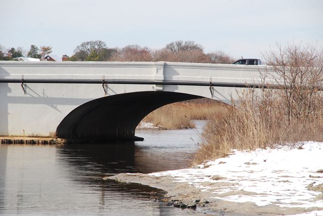
Information and Findings From New Jersey's Historic Bridge InventorySummary The 1916 reinforced concrete arch has paneled parapets with posts with stepped caps. Within the boundaries of the Spring Lake multiple property listing, the unaltered bridge appears eligible under the nomination's specified criteria for landscape and recreation structures. It spans Wreck Pond, a naturally occurring recreational feature and park, and is part of the street plan and general landscaping and public improvements that contributed to Spring Lake's transformation into a resort community. The bridge is individually eligible for listing in the National Register under Criteria A and C, and is a contributing element of the Spring Lake Multiple Property District. Setting/Context The two lane bridge with two sidewalks spans Wreck Pond on the corporate line between Spring Lake to the north and Sea Girt to the south. The neighborhood is a well-maintained coastal resort community with late-19th and early 20th-century detached houses bordering the lake. Spring Lake Borough is a National Register multiple property listing (1870-1935) including hotels and boarding houses, residences, churches, commercial and civic buildings, and landscape and recreation structures. Physical Description The First Avenue bridge carries two lanes of traffic with two sidewalks over Wreck Pond. The bridge is a 77-foot span reinforced-concrete elliptical arch. It has concrete parapets with paneled posts with stepped caps. The parapets extend over the long, plain concrete wing walls. Utility pipes have been added on the downstream side of the bridge. The span appears to survive in unaltered condition. Historical and Technological Significance The First Avenue reinforced concrete arch bridge built in 1916 is significant for its historical
association (Criterion A) with the development of Spring Lake as a shore resort from 1870 to 1935. It meets the registration requirements
for landscape and recreational structures (Property Type #5, Section F, pp. 23-28) in the 1990 Spring Lake Multiple Property
Documentation Form. Spring Lake is a well-preserved resort community with numerous surviving hotels, summer residences, churches,
civic and business buildings, and landscape features. It is representative of several Jersey Shore resorts that in the late nineteenth
century were established and promoted by real estate developers. Boundary Description and Justification The bridge is eligible under the existing registration requirements spelled out in the 1990 Spring Lake Multiple Property Documentation Form National Register nomination. The boundaries of the nomination are the Spring Lake Borough corporate boundaries. Wreck Pond is Spring Lake Borough's southern corporate boundary and the bridge spans the pond, so it is within the National Register listed area. Sources Office of New Jersey Heritage. National Register File: Monmouth County; Spring Lake, New Jersey as a Coastal Resort, 1870-1935, 1990. Bridge Considered Historic By Survey: Yes |
![]()
![]()
![]()
Coordinates (Latitude, Longitude):
Search For Additional Bridge Listings:
Bridgehunter.com: View listed bridges within 0.5 miles (0.8 kilometers) of this bridge.
Bridgehunter.com: View listed bridges within 10 miles (16 kilometers) of this bridge.
Additional Maps:
Google Streetview (If Available)
GeoHack (Additional Links and Coordinates)
Apple Maps (Via DuckDuckGo Search)
Apple Maps (Apple devices only)
Android: Open Location In Your Map or GPS App
Flickr Gallery (Find Nearby Photos)
Wikimedia Commons (Find Nearby Photos)
Directions Via Sygic For Android
Directions Via Sygic For iOS and Android Dolphin Browser
USGS National Map (United States Only)
Historical USGS Topo Maps (United States Only)
Historic Aerials (United States Only)
CalTopo Maps (United States Only)

© Copyright 2003-2025, HistoricBridges.org. All Rights Reserved. Disclaimer: HistoricBridges.org is a volunteer group of private citizens. HistoricBridges.org is NOT a government agency, does not represent or work with any governmental agencies, nor is it in any way associated with any government agency or any non-profit organization. While we strive for accuracy in our factual content, HistoricBridges.org offers no guarantee of accuracy. Information is provided "as is" without warranty of any kind, either expressed or implied. Information could include technical inaccuracies or errors of omission. Opinions and commentary are the opinions of the respective HistoricBridges.org member who made them and do not necessarily represent the views of anyone else, including any outside photographers whose images may appear on the page in which the commentary appears. HistoricBridges.org does not bear any responsibility for any consequences resulting from the use of this or any other HistoricBridges.org information. Owners and users of bridges have the responsibility of correctly following all applicable laws, rules, and regulations, regardless of any HistoricBridges.org information.
![]()