

View Information About HSR Ratings
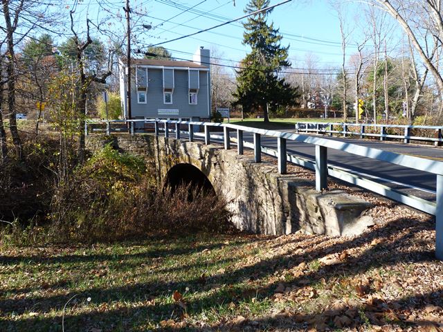
This is a locally rare example of a stone and brick arch bridge, with stone spandrel and brick barrel. In 1935 it was widened on one side with steel stringers.
Information and Findings From New Jersey's Historic Bridge InventorySummary Constructed in ca. 1850, the single-span, brick arch with stone fascia bridge was built at the time the Somerville & Easton Railroad, predecessor of the Central Railroad of New Jersey, extended its line to White House and founded North Branch Station. The arch retains its integrity although the bridge was widened in 1935 with steel stringers on the upstream side. Due to its early date of construction and association with the early development of railroads in the county, the bridge is eligible. Setting/Context The bridge carries a 2-lane road over a small brook on the northern edge of the village of North Branch Station. To the south of the bridge is New Jersey Transit's Raritan Valley Line, formerly the Central Railroad of New Jersey, which also crosses Chambers Brook on a bricklined arch (c.1848). Near the intersection of Station Road and Centre Street once stood the North Branch Depot. North Branch Station village has many older homes and structures, but most have modern alterations. Physical Description The bridge is a single-span elliptical brick arch with stone spandrel walls, abutments, and wingwalls. The stone masonry is random-course rubblestone with rusticated stone voussoirs. The bridge has been widened on the upstream side with two steel stringers inset into stone masonry at an angle to accommodate an extra lane leading into a Y-shaped intersection on the southern side of the bridge. Some concrete reinforcing has been made to the northeastern abutment to support one of the stringers. Beam guide rails have been added to the bridge. There is no evidence of previous railings or parapets. Some of the masonry has been repointed or covered with concrete, but not to a significant degree. Historical and Technological Significance The ca. 1850 brick arch bridge is the only known highway example of its type in Somerset County. Historically it appears to be associated with the founding of the village of North Branch Station, s small settlement that developed as a result of the 1848 development of the Somerville & Easton Railroad through the area. Although its construction is not documented, the bridge is the same type and style as a nearby span built by the railroad in 1848 to carry the line over Dumont Creek at Milepost 39.40. Although the brick arch bridge has been altered on one side, it still retains excellent integrity and is a technologically distinguished example of a brick arch span preserved in its original setting (criterion C). Masonry arch bridges are not uncommon in Somerset County and were built from the 17th century into the 20th century. Most bridges made use of locally quarried stone, and although brick and other dressed stones were available, they were less frequently used due to the costs of shipping, a situation that began to change with the construction of canals and railroads. Although no construction records for the Station Road bridge have been located, it is possible that the bridge was constructed in 1848 when the Somerville and Easton Railroad, one of the precursors of the Central New Jersey Railroad, extended its line from Somerville to White House. A similar brick arch bridge with stone spandrel walls and a documented date of 1848 carries the railroad and a portion of the North Branch Station house over a branch of Chambers Creek just upstream from the highway bridge. The station building no longer exists, although a modern structure has been built on its foundations. The 1848 brick arch railroad bridge at milepost 39.40 is the earliest documented bridge in the 1991 NJT survey population, and it was evaluated as eligible. County records indicate the bridge was widened with stringers at one quadrant in 1935. Boundary Description and Justification The bridge is evaluated as individually significant. The boundary is limited to the arch span itself and the ashlar wingwalls. The 1935 addition does not contribute to the significance of the arch bridge. Sources DeLeuw, Cather, and Co. New Jersey Transit Railroad Bridge Survey, 1991. Somerset County Engineer. County Bridge Cards. 1935. Snell, James. History of Hunterdon and Somerset Counties, 1881. Bridge Considered Historic By Survey: Yes |
![]()
![]()
![]()
Coordinates (Latitude, Longitude):
Search For Additional Bridge Listings:
Bridgehunter.com: View listed bridges within 0.5 miles (0.8 kilometers) of this bridge.
Bridgehunter.com: View listed bridges within 10 miles (16 kilometers) of this bridge.
Additional Maps:
Google Streetview (If Available)
GeoHack (Additional Links and Coordinates)
Apple Maps (Via DuckDuckGo Search)
Apple Maps (Apple devices only)
Android: Open Location In Your Map or GPS App
Flickr Gallery (Find Nearby Photos)
Wikimedia Commons (Find Nearby Photos)
Directions Via Sygic For Android
Directions Via Sygic For iOS and Android Dolphin Browser
USGS National Map (United States Only)
Historical USGS Topo Maps (United States Only)
Historic Aerials (United States Only)
CalTopo Maps (United States Only)

© Copyright 2003-2024, HistoricBridges.org. All Rights Reserved. Disclaimer: HistoricBridges.org is a volunteer group of private citizens. HistoricBridges.org is NOT a government agency, does not represent or work with any governmental agencies, nor is it in any way associated with any government agency or any non-profit organization. While we strive for accuracy in our factual content, HistoricBridges.org offers no guarantee of accuracy. Information is provided "as is" without warranty of any kind, either expressed or implied. Information could include technical inaccuracies or errors of omission. Opinions and commentary are the opinions of the respective HistoricBridges.org member who made them and do not necessarily represent the views of anyone else, including any outside photographers whose images may appear on the page in which the commentary appears. HistoricBridges.org does not bear any responsibility for any consequences resulting from the use of this or any other HistoricBridges.org information. Owners and users of bridges have the responsibility of correctly following all applicable laws, rules, and regulations, regardless of any HistoricBridges.org information.
![]()