

View Information About HSR Ratings
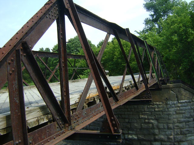
This highway over railroad bridge was likely moved to this location in 1906 from an unknown previous location. The design of the truss members, quite different from most highway truss bridges of the period, is representative of the different design approach taken by railroads. Bridges of this style designed by the railroads seen today are often not in their original location as the railroads seem to have moved them around as needed, much like they did with any bridges they owned. This bridge appears to be an example of that, as the style of bridge is typically older than the 1906 construction date given. Further, the abutments consist of stone abutments with a concrete section added on top. This concrete section bears the date 1906.
Joel Wyman reported the following:
Sadly this bridge no longer exists and was removed sometime early this year due to teenage vandals. It was closed in 2006 due to the poor state of its deck and was supposed to be repaired as per the sign down the road a mile or so but instead the funds were allocated elsewhere.
Demolition of a historic bridge is a complete over-reaction and an improper response to teenage vandals. The proper response would be to address the problem: Arrest the teenagers, contact the parents, throw them in the prison located less than two miles from this bridge, etc. Allowing teenagers to dictate historic bridge preservation policy is just plain ridiculous.
This bridge is tagged with the following special condition(s): Unorganized Photos
![]()
![]()
![]()
This historic bridge has been demolished. This map is shown for reference purposes only.
Coordinates (Latitude, Longitude):
Search For Additional Bridge Listings:
Bridgehunter.com: View listed bridges within 0.5 miles (0.8 kilometers) of this bridge.
Bridgehunter.com: View listed bridges within 10 miles (16 kilometers) of this bridge.
Additional Maps:
Google Streetview (If Available)
GeoHack (Additional Links and Coordinates)
Apple Maps (Via DuckDuckGo Search)
Apple Maps (Apple devices only)
Android: Open Location In Your Map or GPS App
Flickr Gallery (Find Nearby Photos)
Wikimedia Commons (Find Nearby Photos)
Directions Via Sygic For Android
Directions Via Sygic For iOS and Android Dolphin Browser
USGS National Map (United States Only)
Historical USGS Topo Maps (United States Only)
Historic Aerials (United States Only)
CalTopo Maps (United States Only)

© Copyright 2003-2026, HistoricBridges.org. All Rights Reserved. Disclaimer: HistoricBridges.org is a volunteer group of private citizens. HistoricBridges.org is NOT a government agency, does not represent or work with any governmental agencies, nor is it in any way associated with any government agency or any non-profit organization. While we strive for accuracy in our factual content, HistoricBridges.org offers no guarantee of accuracy. Information is provided "as is" without warranty of any kind, either expressed or implied. Information could include technical inaccuracies or errors of omission. Opinions and commentary are the opinions of the respective HistoricBridges.org member who made them and do not necessarily represent the views of anyone else, including any outside photographers whose images may appear on the page in which the commentary appears. HistoricBridges.org does not bear any responsibility for any consequences resulting from the use of this or any other HistoricBridges.org information. Owners and users of bridges have the responsibility of correctly following all applicable laws, rules, and regulations, regardless of any HistoricBridges.org information.
![]()