We Recommend:
Bach Steel - Experts at historic truss bridge restoration.
BridgeHunter.com Phase 1 is released to the public! - Visit Now
George Washington Bridge
Primary Photographer(s): Nathan Holth and Rick McOmber
Bridge Documented: July 12, 2008 and September 2, 2019
Fort Lee and New York: Bergen County, New Jersey and Manhattan, New York: United States
Metal Deck Truss Stiffening Wire Cable Suspension, Fixed and Approach Spans: Metal Stringer (Multi-Beam), Fixed
1931 By Builder/Contractor: McClintic-Marshall Company of Pittsburgh, Pennsylvania and Engineer/Design: Othmar Ammann
1962
3,500.0 Feet (1066.8 Meters)
4,980.2 Feet (1518 Meters)
119 Feet (36.27 Meters)
1 Main Span(s) and 18 Approach Span(s)
5522508

View Information About HSR Ratings
Bridge Documentation
View Archived National Bridge Inventory Report - Has Additional Details and Evaluation
View Historic American Engineering Record (HAER) Documentation For This Bridge
HAER Data Pages, PDF
View A Historical Article About The Construction of This Bridge From The Perspective of Roebling and Sons Company
View A Historical Article About A Testing Machine Created For This Bridge
View Historical Article About This Bridge
View Historical Reports About The Bridge's Construction
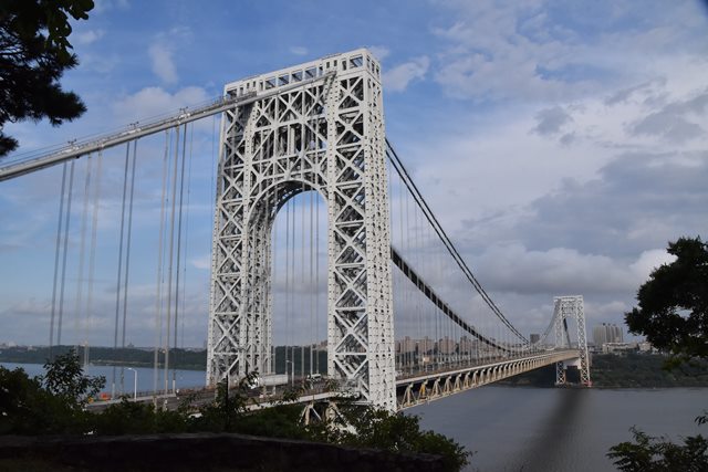
This bridge overtook the Ambassador Bridge as the longest suspension span in the world when completed. The bridge is noted for its distinctive towers. The towers were originally intended to be encased in concrete, but public opinion strongly favored the geometric art of the open network of bracing and trussing in the towers.
The bridge was altered in 1962 when a lower deck level was added to the bridge.
The George Washington Bridge carries one of the largest volumes of traffic of any bridge in the world. Given the volume of traffic using this bridge, it likely is not unusual for the bridge to turn into a parking lot. The good news is because this is a beautiful historic bridge, travelers who find themselves trapped on the bridge can at least enjoy the design and details of this landmark historic bridge.
More information is available here.
Below are some historical photos taken during the construction of the bridge that provide a more complete look into not only the design of the bridge but the impressive construction process employed to erect the bridge.
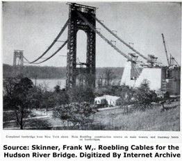
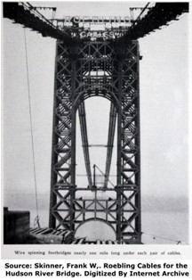
Above: The initial construction of the cable system always starts with small cables, which are then used to install the larger cables. Here, the smaller cables, which supported the foot bridge that ran across the bridge are laid on the ground. After being laid out on the ground and in water, they were hoisted up into place over the river where they followed the profile of the main cable which would then be constructed using the method of cable spinning.
Above are photos showing the general construction of the bridge superstructure before anything having to do with the deck and roadway was begun. In other words, the towers and main cables are the only thing that construction work was focused on at this time.
Above: Photo showing anchorage construction.
Above: Detail photo showing how the wire cables tie into eyebars at the anchorages.
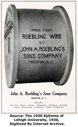
Above: Overview of the Roebling and Sons Company plant where the cables for the George Washington Bridge were manufactured.
Above: The cables to be used on the bridge were tested in a variety of ways. Here, a sample section of the proposed main cable was tested.
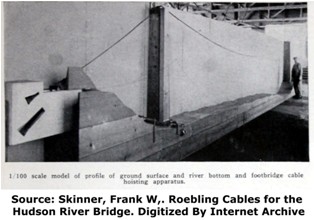
Above: Scale models of the bridge, including this one showing how the pedestrian walkway cables would be hoisted up, were employed during the design and construction process.
Above: Cables for the bridge being galvanized in the plant.
Above: Cables for the bridge loaded onto railroad cars and ready for shipment to the bridge site.
![]()
Photo Galleries and Videos: George Washington Bridge
Bridge Photo-Documentation
Original / Full Size PhotosA collection of overview and detail photos. This gallery offers photos in the highest available resolution and file size in a touch-friendly popup viewer.
Alternatively, Browse Without Using Viewer
![]()
Bridge Photo-Documentation
Mobile Optimized PhotosA collection of overview and detail photos. This gallery features data-friendly, fast-loading photos in a touch-friendly popup viewer.
Alternatively, Browse Without Using Viewer
![]()
Maps and Links: George Washington Bridge
Coordinates (Latitude, Longitude):
Search For Additional Bridge Listings:
Bridgehunter.com: View listed bridges within 0.5 miles (0.8 kilometers) of this bridge.
Bridgehunter.com: View listed bridges within 10 miles (16 kilometers) of this bridge.
Additional Maps:
Google Streetview (If Available)
GeoHack (Additional Links and Coordinates)
Apple Maps (Via DuckDuckGo Search)
Apple Maps (Apple devices only)
Android: Open Location In Your Map or GPS App
Flickr Gallery (Find Nearby Photos)
Wikimedia Commons (Find Nearby Photos)
Directions Via Sygic For Android
Directions Via Sygic For iOS and Android Dolphin Browser
USGS National Map (United States Only)
Historical USGS Topo Maps (United States Only)
Historic Aerials (United States Only)
CalTopo Maps (United States Only)


