We Recommend:
Bach Steel - Experts at historic truss bridge restoration.
BridgeHunter.com Phase 1 is released to the public! - Visit Now
Hopeton Mills Bridge
Keuka Lake Outlet Bridge

Primary Photographer(s): Marc Scotti
Bridge Documented: August 9, 2010
Rural: Yates County, New York: United States
By Builder/Contractor: Unknown
Not Available or Not Applicable
Not Available
Not Available
Not Available
1 Main Span(s)
Not Applicable

View Information About HSR Ratings
Bridge Documentation
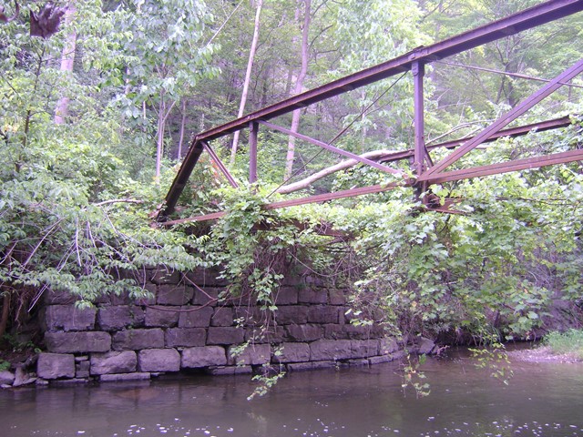
This bridge, abandoned and at risk for collapse, has unusual details and has been closed so long there is no evidence of whatever road it served leading up to it.
The builder of this bridge is not confirmed. It has extremely rare pins. Almost always, bridge pins are threaded rod, with threads at both end. This bridge's pins are instead essentially giant square-head bolts, with threads at one end and the square head at the other. This type of pin was likely not widely used because it would have been harder to install (and remove of the bridge was moved) since it would only be able to be pounded in one way. The King Bridge Company of Cleveland, Ohio was known for using these pins on bridges built in 1880 and 1881. This bridge also has unusually shaped eyebar heads, which are of the upset type, but come to a slight point at the ends, rather than the usual circular curve. This is also shared with the 1880 Hendricks Ford Bridge in Indiana by King Bridge Company. Beyond those, this bridge does not bear any other obvious details of the King Bridge Company. The verticals are rolled members, which is also unusual for a bridge of this type, and not a detail that King was known to use on Pratt trusses.
This bridge sits on stone abutments that are deteriorating and a tree has fallen on the bridge. It should be considered at risk for collapse.
This area has a lot of history. The Crooked Lake Canal ran next to this outlet, and a railroad nearby is today a rail-trail. The bridge is within a National Register Historic District, and is next to a contributing mill site. The bridge is photographed for the nomination, but does not appear listed as a contributing structure. This is a severe oversight on the part of the Historic District, as this bridge clearly contributes. The truss itself retains historic integrity despite abandonment and loss of deck (which is not a character-defining feature).
View National Register of Historic Places Nomination Form For Keuka Lake Outlet Historic District
This bridge is tagged with the following special condition(s): Unorganized Photos
![]()
Photo Galleries and Videos: Hopeton Mills Bridge
Unorganized Photos
Original / Full Size PhotosA collection of overview and detail photos, presented as an unorganized and unlabeled collage and gallery. This gallery offers photos in the highest available resolution and file size in a touch-friendly popup viewer.
Alternatively, Browse Without Using Viewer
![]()
Unorganized Photos
Mobile Optimized PhotosA collection of overview and detail photos, presented as an unorganized and unlabeled collage and gallery. This gallery features data-friendly, fast-loading photos in a touch-friendly popup viewer.
Alternatively, Browse Without Using Viewer
![]()
Maps and Links: Hopeton Mills Bridge
Coordinates (Latitude, Longitude):
Search For Additional Bridge Listings:
Bridgehunter.com: View listed bridges within 0.5 miles (0.8 kilometers) of this bridge.
Bridgehunter.com: View listed bridges within 10 miles (16 kilometers) of this bridge.
Additional Maps:
Google Streetview (If Available)
GeoHack (Additional Links and Coordinates)
Apple Maps (Via DuckDuckGo Search)
Apple Maps (Apple devices only)
Android: Open Location In Your Map or GPS App
Flickr Gallery (Find Nearby Photos)
Wikimedia Commons (Find Nearby Photos)
Directions Via Sygic For Android
Directions Via Sygic For iOS and Android Dolphin Browser
USGS National Map (United States Only)
Historical USGS Topo Maps (United States Only)
Historic Aerials (United States Only)
CalTopo Maps (United States Only)

