

View Information About HSR Ratings
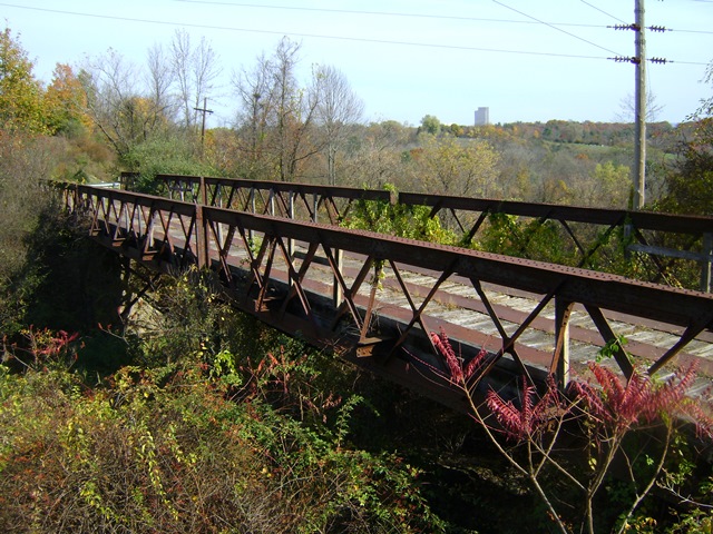
This unique Double-Warren pony truss bridge crosses the original Delaware and Hudson main line, which was re-routed a long time ago. The truss configuration and the heavy use of angles and plates with no lacing or lattice indicates this was a railroad-designed bridge. Such bridges also have a history of relocation so it is not known if this is the original location of the trusses. The 1914 construction date given by the National Bridge Inventory certainly suggests relocation as it is assumed the truss spans are older based on design. Similar bridges that are more massive in construction have been dated to ca. 1890 or earlier. There is no reason to believe this bridge is not at least that old as well. The SHPO database had a ca. 1906 date listed. The accuracy of either date is unknown.
This example stands out from similar examples nationwide due to its multi-span configuration and use of riveted steel bents.
The bridge was abandoned, but not in the way of anything, and it would have been a major, highly significant historic landmark along the rail-trail so whoever thought it was a good idea to demolish this bridge was clearly devoid of any common sense, decency, or respect for the use of taxpayer dollars. The loss of a highly significant truss like this for no reason is absolutely ridiculous and shameful. This is not even the worst of it however!!! The SHPO (that would be the State HISTORIC PRESERVATION Office) listed this bridge as INELIGIBLE for listing in the National Register of Historic Places "because it lacks distinguishing characteristics and is in poor condition." This shows a complete lack of understanding of what makes a bridge eligible for the National Register. Is there not a single bridge historian working for the SHPO?! No distinguishing features?! What do they think a rare railroad-designed steel angle-plate-based truss bridge that MIGHT date to 1906 but could very well be older (no source for that date was cited) is?! Also, because a truss bridge is in poor condition is absolutely no excuse for an ineligible finding if that were the case nearly every historic metal bridge in the United States would be found inelgible including nationally significant bridges like the Brooklyn Bridge which prior to rehab was in very poor condition. The National Register is not a bridge inspection rating system. It is not based off how deteriorated a bridge is. As long as the deterioration has not resulted in actual character-defining bridge parts missing or becoming beyond in-kind repair/replacement in keeping with the Secretary of Interior Standards for Rehabilitation (which this bridge had NOT deteriorated even close to that point) then the bridge should be found eligible. As if to rub salt in the wound, the SHPO also found a nearby tiny culvert-sized cattle pass, merely a slab of rotting wood (in other words in POOR CONDITION) on stone abutments built ca. 1890 as ELIGIBLE. While HistoricBridges.org does not dispute that finding, this lack of consistency makes no sense whatsoever. Perhaps an unpaid intern did this report?
This bridge is tagged with the following special condition(s): Unorganized Photos
![]()
![]()
![]()
This historic bridge has been demolished. This map is shown for reference purposes only.
Coordinates (Latitude, Longitude):
Search For Additional Bridge Listings:
Bridgehunter.com: View listed bridges within 0.5 miles (0.8 kilometers) of this bridge.
Bridgehunter.com: View listed bridges within 10 miles (16 kilometers) of this bridge.
Additional Maps:
Google Streetview (If Available)
GeoHack (Additional Links and Coordinates)
Apple Maps (Via DuckDuckGo Search)
Apple Maps (Apple devices only)
Android: Open Location In Your Map or GPS App
Flickr Gallery (Find Nearby Photos)
Wikimedia Commons (Find Nearby Photos)
Directions Via Sygic For Android
Directions Via Sygic For iOS and Android Dolphin Browser
USGS National Map (United States Only)
Historical USGS Topo Maps (United States Only)
Historic Aerials (United States Only)
CalTopo Maps (United States Only)

© Copyright 2003-2026, HistoricBridges.org. All Rights Reserved. Disclaimer: HistoricBridges.org is a volunteer group of private citizens. HistoricBridges.org is NOT a government agency, does not represent or work with any governmental agencies, nor is it in any way associated with any government agency or any non-profit organization. While we strive for accuracy in our factual content, HistoricBridges.org offers no guarantee of accuracy. Information is provided "as is" without warranty of any kind, either expressed or implied. Information could include technical inaccuracies or errors of omission. Opinions and commentary are the opinions of the respective HistoricBridges.org member who made them and do not necessarily represent the views of anyone else, including any outside photographers whose images may appear on the page in which the commentary appears. HistoricBridges.org does not bear any responsibility for any consequences resulting from the use of this or any other HistoricBridges.org information. Owners and users of bridges have the responsibility of correctly following all applicable laws, rules, and regulations, regardless of any HistoricBridges.org information.
![]()