

View Information About HSR Ratings
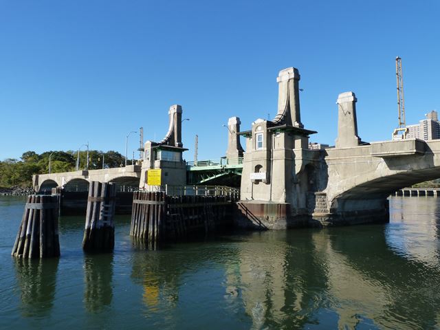
Built in 1908, this noteworthy bridge has two components. It has concrete arch approach spans that have 125 foot span lengths. These lead up to a tiny 80 foot double-leaf bascule bridge. As such, this is an odd case where the main span is not the longest span on the bridge.
The concrete arch spans appear to have been shotcrete or gunnite applied to them at some point. Despite this, they are noteworthy as early surviving examples of a concrete arch bridge in New York State. An unusual detail is that the piers and abutments for the concrete arch spans are either stone or are stone-faced concrete.
The bascule span is also an early surviving example of its type, specifically a Scherzer type rolling lift bascule bridge. This bridge was designed by the firm that invented the type, the Scherzer Rolling Lift Bridge Company. The bascule trusses have a lightweight look to them, composed of only plate and angles. However, there are four truss lines on this bascule instead of the more common two truss lines. The additional truss lines make up for the lighter weight trusses. The bottom chord of the trusses do not have a polygonal shape like many deck truss bascules. Instead, the bottom chord simply runs at a straight angle to produce a truss with lesser depth at the center of the bascule span.
Aethetics appear to have played a role in the design of this bridge. This is most apparent in the bridge tender houses, with there being four when usually only two were needed. Moreover, these bridge tender houses have substantial architectural detailing that enhances their appearance including decorative towers that rise above the rooflines of the actual buildings.
Unfortunately, this bridge is listed on a demolish and replace list by New York City. It is disappointing that the city is apparently not open to considering rehabilitation of this historically significant bridge.
The 1904 Report of the New York State Bridge and Tunnel Commission described the previous bridge at this location as follows.
The old bridge consists of two iron Moseley arch trusses of about 125 feet span, and one draw span about 140 feet long, with causeway approaches about 900 feet long. It is of antiquated type, and was in need of repair when the Department of Bridges took charge. The two fixed spans have been reinforced by pile bents under the trusses, the drum and turning gear of the draw have been strengthened and repaired, the roadway on the causeway approaches have been macadamized and about 800 feet of new sidewalk have been laid on the approaches. The bridge will be adequate for traffic until the new arch bridge is finished, and meantime serves the purpose of a temporary bridge.
The report describes the previous bridge as a "Moseley arch truss" which likely means it was a bowstring truss built by Moseley Iron Bridge and Roof Company of Boston, Massachusetts. The Hares Hill Road Bridge is an example of a bowstring arch/truss built by this company.
Historical Information Courtesy of the NYC Municipal ArchivesDiscussion of Bridge The Pelham Bay Bridge is a four-lane bascule bridge that carries vehicular and pedestrian traffic over where the Hutchinson River and Eastchester Bay meet. It connects one part of Pelham Bay Park with another and
further provides one of the means by which residents of, and visitors to, City Island can get to the Pelham Bay neighborhood and vice versa. |
![]()
![]()
![]()
Coordinates (Latitude, Longitude):
Search For Additional Bridge Listings:
Bridgehunter.com: View listed bridges within 0.5 miles (0.8 kilometers) of this bridge.
Bridgehunter.com: View listed bridges within 10 miles (16 kilometers) of this bridge.
Additional Maps:
Google Streetview (If Available)
GeoHack (Additional Links and Coordinates)
Apple Maps (Via DuckDuckGo Search)
Apple Maps (Apple devices only)
Android: Open Location In Your Map or GPS App
Flickr Gallery (Find Nearby Photos)
Wikimedia Commons (Find Nearby Photos)
Directions Via Sygic For Android
Directions Via Sygic For iOS and Android Dolphin Browser
USGS National Map (United States Only)
Historical USGS Topo Maps (United States Only)
Historic Aerials (United States Only)
CalTopo Maps (United States Only)

© Copyright 2003-2026, HistoricBridges.org. All Rights Reserved. Disclaimer: HistoricBridges.org is a volunteer group of private citizens. HistoricBridges.org is NOT a government agency, does not represent or work with any governmental agencies, nor is it in any way associated with any government agency or any non-profit organization. While we strive for accuracy in our factual content, HistoricBridges.org offers no guarantee of accuracy. Information is provided "as is" without warranty of any kind, either expressed or implied. Information could include technical inaccuracies or errors of omission. Opinions and commentary are the opinions of the respective HistoricBridges.org member who made them and do not necessarily represent the views of anyone else, including any outside photographers whose images may appear on the page in which the commentary appears. HistoricBridges.org does not bear any responsibility for any consequences resulting from the use of this or any other HistoricBridges.org information. Owners and users of bridges have the responsibility of correctly following all applicable laws, rules, and regulations, regardless of any HistoricBridges.org information.
![]()